Dunkery Hill

Last updated

Dunkery Hill
Dunkery Beacon.jpg
Dunkery Beacon seen on the
ascent up the western slopes
Highest point
Elevation 519 m (1,703 ft) [1]
Prominence 414 m (1,358 ft)
Parent peak High Willhays
Listing Marilyn, County Top
Coordinates 51°09′43″N3°35′14″W / 51.16197°N 3.58736°W / 51.16197; -3.58736 Coordinates: 51°09′43″N3°35′14″W / 51.16197°N 3.58736°W / 51.16197; -3.58736
Geography
Exmoor National Park UK relief location map.png
Red triangle with thick white border.svg
Dunkery Hill
Exmoor, England
OS grid SS891415
Topo map OS Landranger 181

Dunkery Beacon at the summit of Dunkery Hill is the highest point on Exmoor and in Somerset, England. It is also the highest point in southern England outside of Dartmoor.

Contents

The sandstone hill rises to 519 metres (1,703 ft) and provides views over the surrounding moorland, the Bristol Channel and hills up to 86 miles (138 km) away. The site has been visited by humans since the Bronze Age, and contains several burial mounds in the form of cairns and bowl barrows. Sweetworthy on the lower slopes is the site of two Iron Age hill forts or enclosures and a deserted medieval settlement. The hill is part of a Site of Special Scientific Interest and National nature reserve. It was in private ownership until the 20th century, when it was donated to the National Trust by Sir Thomas Acland, Colonel Wiggin and Allan Hughes; a stone cairn was erected at the summit to commemorate the event.

Location

The summit cairn Dunkery Beacon summit cairn.jpg
The summit cairn

Dunkery is composed of Middle Devonian sedimentary rock, ( 393.3 ± 1.2 million years ago) known as the Hangman Sandstone Formation. [2] This supports acidic soils. [3] The ridge along the top of the hill is 4.5 kilometres (2.8 mi) long. [4]

At 519 metres (1,703 ft) ordnance datum (OD), the mean height above sea level, [1] [5] Dunkery Beacon is the highest natural point in Somerset, [6] although the tip of the Mendip TV Mast is higher at 589 metres (1,932 ft) OD. [7] Dunkery is ranked 23rd in the UK in terms of dominance and is a Marilyn, meaning that it is a peak with 150 metres (490 ft) or more of relative height. The nearest higher hill is Yes Tor, 37 miles (60 km) away. John Fry, a character in R. D. Blackmore's 1869 novel Lorna Doone , calls it the "haighest place of Hexmoor". [8]

Dunkery lies just four miles (6.4 km) from the Bristol Channel at Porlock. The shortest route of ascent goes from the car park at Dunkery Gate, and is just 0.75 miles (1.2 km) long. There are extensive views from the summit, from where the Bristol and English Channel coasts, the Brecon Beacons including Pen Y Fan, Bodmin Moor, Dartmoor, the Severn Bridges and Cleeve Hill 86 miles (138 km) away in Gloucestershire are visible. [9]

History

Dunkery Hill was part of the "Royal Forest of Exmoor", established by Henry II according to the late 13th-century Hundred Rolls. There has been some debate about the origin of the name "Dunkery" and its predecessors "Duncrey" and "Dunnecray". [10] Eilert Ekwall suggests that it comes from the Welsh din meaning hillfort and creic or creag meaning rock. [11] [12]

There are several Bronze Age burial mounds at or near the summit. [4] [13] Two of the largest are Joaney How and Robin How, which have been damaged over many years, although plans have been made to restore and protect them. [14] "How" comes from the Norse for burial mound. [15] Joaney How on the northern slope, is more than 22 metres (72 ft) in diameter. [16] [17] On the southeastern slopes are four more cairns, [18] and there are a further two round cairns 390 metres (1,280 ft) and 420 metres (1,380 ft) southeast of Rex Stile Head. [19] In addition to the cairns are barrows, which also date from the Bronze Age. One bowl barrow on the southeastern spur of the Chains is 12.3 metres (40 ft) in diameter. [20] A circular funerary stone mound 850 metres (2,790 ft) north of Dunkery Bridge, which is a 1.5-mile (2.4 km) walk from the summit, dates from the Neolithic or Bronze Age. It is approximately 1.5 metres (4 ft 11 in) high and 14 metres (46 ft) in diameter. [21] [22]

The National Trust plaque on the summit Dunkery plaque.jpg
The National Trust plaque on the summit

Sweetworthy, on Dunkery Hill's north-facing slope, is the site of two Iron Age hillforts or enclosures; [23] [24] one has a single rampart and external ditch, enclosing 0.25 hectares (0.62 acres). [25] The rampart is still visible, and the ditch on the east side is used as a trackway. [26] [27] There was a defended settlement above the main site. [28] It is also the site of a deserted medieval settlement, which has been designated a scheduled monument. [29] [30] It has been added to the Heritage at Risk Register because of the vulnerability to plant growth. [31]

In 1918 Sir Thomas Acland granted to the National Trust a 500-year lease of a large part of the Holnicote Estate, including Dunkery Hill. [32] Dunkery Hill was put up for sale in 1928. Labour Party activist and Member of Parliament Margaret Bondfield asked in the House of Commons if the government was willing to have it designated an ancient monument, to preserve it for future generations. She received the reply that although the government was agreeable to having the hill listed there were no funds available for its purchase; [33] the beacon and surrounding mounds were subsequently designated an ancient monument. [34] The beacon itself, and 960 acres (390 ha) of surrounding land, was donated in 1932 by Colonel W.W. Wiggin. A further 945 acres (382 ha) of nearby land was donated in 1934 by Mrs Hughes in memory of her husband Alan Hughes of Lynch Allerford, Minehead. [32] The donations were commemorated in 1935 with an event when a plaque was attached to the summit memorial cairn. Further parts of the Holnicote Estate, which includes other land donated by the Acland family and others, was given in subsequent years. [35] [36] [37] [38]

Ecology

The site is part of the North Exmoor Site of Special Scientific Interest (SSSI), part of the Dunkery & Horner Woods National Nature Reserve [39] and part of the Exmoor Coastal Heaths Special Area of Conservation. [40]

The hill is blanketed in heather, which gives it a deep purple colour during the summer. Ling and bell heather, gorse, sessile oak, ash, rowan, hazel, bracken, mosses, liverworts, lichens and ferns all grow on the hill or in surrounding woodland, as well as some unique whitebeam species. Exmoor ponies, red deer, pied flycatchers, wood warblers, lesser spotted woodpeckers, redstarts, dippers, snipe, skylarks and kestrels are some of the fauna to be found on or around the hill and in nearby Horner Woods, home to 14 of the 16 UK bat species and including barbastelle and Bechstein's bats. [37] [41]

Related Research Articles

<span class="mw-page-title-main">Exmoor</span> Area of hilly open moorland in west Somerset and north Devon in South West England

Exmoor is loosely defined as an area of hilly open moorland in west Somerset and north Devon in South West England. It is named after the River Exe, the source of which is situated in the centre of the area, two miles north-west of Simonsbath. Exmoor is more precisely defined as the area of the former ancient royal hunting forest, also called Exmoor, which was officially surveyed 1815–1818 as 18,810 acres (7,610 ha) in extent. The moor has given its name to a National Park, which includes the Brendon Hills, the East Lyn Valley, the Vale of Porlock and 55 km (34 mi) of the Bristol Channel coast. The total area of the Exmoor National Park is 692.8 km2 (267.5 sq mi), of which 71% is in Somerset and 29% in Devon.

<span class="mw-page-title-main">West Bagborough</span> Human settlement in England

West Bagborough is a village and civil parish in Somerset, England, about 5 miles (8.0 km) north of Taunton in the Somerset West and Taunton district. In 2011 the village had a population of 358.

<span class="mw-page-title-main">Geology of Somerset</span>

Somerset is a rural county in the southwest of England, covering 4,171 square kilometres (1,610 sq mi). It is bounded on the north-west by the Bristol Channel, on the north by Bristol and Gloucestershire, on the north-east by Wiltshire, on the south-east by Dorset, and on the south west and west by Devon. It has broad central plains with several ranges of low hills. The landscape divides into four main geological sections from the Silurian through the Devonian and Carboniferous to the Permian which influence the landscape, together with water-related features.

<span class="mw-page-title-main">Holnicote Estate</span> Estate in Selworthy, England

Holnicote in the parish of Selworthy, West Somerset, England, is a historic estate consisting of 12,420 acres of land, much situated within the Exmoor National Park.

<span class="mw-page-title-main">Mountains and hills of England</span>

The mountains and hills of England comprise very different kinds of terrain, from a mountain range which reaches almost 1,000 metres high, to several smaller areas of lower mountains, foothills and sea cliffs. Most of the major upland areas have been designated as Areas of Outstanding Natural Beauty (AONB) or national parks. The highest and most extensive areas are in the north and west, while the midlands, south-east and east of the country tend to be low-lying.

<span class="mw-page-title-main">Luccombe, Somerset</span> Human settlement in England

Luccombe or Luckham is a village and civil parish in the Exmoor National Park in the English county of Somerset. It at the foot of the moor's highest hill, the 1,750 feet (533 m) Dunkery Beacon, and is about one mile south of the A39 road between Porlock and Minehead. Administratively it forms part of the district of Somerset West and Taunton. The parish includes the hamlets of Stoke Pero and Horner, as well as the former hamlet of Wilmersham.

<span class="mw-page-title-main">Selworthy</span> Human settlement in England

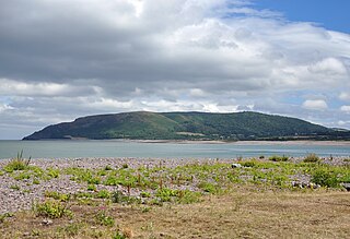
Selworthy is a small village and civil parish 5 kilometres (3 mi) from Minehead in Somerset, England. It is located in the National Trust's Holnicote Estate on the northern fringes of Exmoor. The parish includes the hamlets of Bossington, Tivington, Lynch, Brandish Street and Allerford.

<span class="mw-page-title-main">Wills Neck</span>

Wills Neck is the highest summit on the Quantock Hills and one of the highest points in Somerset, England. Although only 1261 ft (384 m) high, it qualifies as one of England's Marilyns. It is situated about 8 miles (13 km) north west of the historic market town of Taunton.

<span class="mw-page-title-main">Rough Tor</span> Tor on Bodmin Moor, Cornwall, England

Rough Tor, or Roughtor, is a tor on Bodmin Moor, Cornwall, United Kingdom. The site is composed of the tor summit and logan stone, a neolithic tor enclosure, a large number of Bronze Age hut circles, and some contemporary monuments.

<span class="mw-page-title-main">Sweetworthy</span> Site of two Iron Age hillforts in Somerset, England

Sweetworthy is the site of two Iron Age hill forts or enclosures at Luccombe, 4 kilometres (2 mi) south of Porlock, Somerset, England. They are on the north-facing slope of Dunkery Hill. One has a single rampart and external ditch, enclosing 0.25 hectares. The rampart is still visible and the ditch on the east side is used as a trackway. There was a defended settlement above the main site.

<span class="mw-page-title-main">Briercliffe</span> Human settlement in England

Briercliffe is a civil parish in the borough of Burnley, in Lancashire, England. It is situated 3 miles (4.8 km) north of Burnley. The parish contains suburbs of Burnley, and the rural area north east of the town. Hamlets in the parish include Cockden, Lane Bottom and in the Extwistle area, the tiny hamlet of Roggerham. According to the United Kingdom Census 2011, the parish has a population of 4,031.

<span class="mw-page-title-main">Gallox Bridge, Dunster</span> Bridge in Somerset, England

The Gallox Bridge in Dunster, Somerset, England dates from the 15th century. It has been designated as a Grade I listed building and scheduled monument. The bridge is in the guardianship of English Heritage.

<span class="mw-page-title-main">River Avill</span> River in Somerset, England

The River Avill is a small river on Exmoor in Somerset, England.

<span class="mw-page-title-main">Selworthy Beacon</span>

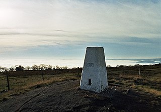
Selworthy Beacon is a hill and Marilyn of Exmoor in Somerset, England. It lies within the boundaries of Exmoor National Park, to the north of the village of Selworthy and northwest of Minehead. A road leads to the top, where there is a National Trust plaque and a view of the south coast of Wales across the Bristol Channel. The South West Coast Path also climbs the hill and ends slightly shy of the summit.

<span class="mw-page-title-main">Lanacombe</span> Area of Exmoor in Somerset, England

Lanacombe is an area of Exmoor in Somerset, South West England. It is the site of several standing stones and cairns which have been scheduled as ancient monuments.

<span class="mw-page-title-main">Withypool Stone Circle</span> Late neolithic stone circle in Somerset, England

Withypool Stone Circle, also known as Withypool Hill Stone Circle, is a stone circle located on the Exmoor moorland, near the village of Withypool in the southwestern English county of Somerset. The ring is part of a tradition of stone circle construction that spread throughout much of Britain, Ireland, and Brittany during the Late Neolithic and Early Bronze Age, over a period between 3300 and 900 BCE. The purpose of such monuments is unknown, although archaeologists speculate that the stones represented supernatural entities for the circle's builders.

West Somerset was a local government district in the English county of Somerset. It merged with Taunton Deane to form Somerset West and Taunton on 1 April 2019.

West Somerset was a local government district located in the English county of Somerset. It merged with Taunton Deane to form Somerset West and Taunton on 1 April 2019.

References

  1. 1 2 Bathurst, David (2012). Walking the county high points of England. Chichester: Summersdale. pp. 174–181. ISBN   978-1-84-953239-6.
  2. British Geological Survey 1975 Dulverton England and Wales sheet 294 Solid & Drift Geology. 1:50,000 scale geological map (Keyworth, Nottingham: British Geological Survey)
  3. Prudden, Hugh. "Somerset Good Rock Guide" (PDF). University of Bath. Retrieved 24 January 2015.
  4. 1 2 "MSO9187 – Group of Bronze Age cairns at Dunkery Beacon". Exmoor Historic Environment Record. Exmoor National Park. Retrieved 24 January 2015.
  5. "The uplands of South West England" (PDF). Dartmoor National Park Authority. Retrieved 24 January 2015.
  6. "Exmoor National Park Facts and Figures". Exmoor National Park. Retrieved 24 January 2015.
  7. "Mendip". The Big Tower. Retrieved 6 April 2018.
  8. Blackmore, Richard Dodderidge (2014). Lorna Doone: A Romance of Exmoor. Animedia Company. ISBN   978-80-7499-082-3.
  9. "Dunkery Beacon, Exmoor". Countryfile. BBC. Retrieved 28 April 2015.
  10. "Dunkery Beacon" . Taunton Courier, and Western Advertiser. 21 October 1939. Retrieved 24 January 2015 via British Newspaper Archive.
  11. Ekwall, Eilert (1960). The Concise Oxford Dictionary of English Place Names. Oxford University Press. p. 153. ISBN   978-0-19-869103-7.
  12. Muir, Jonny (2014). The UK's County Tops: Reaching the top of 91 historic counties. Cicerone Press. pp. 24–25. ISBN   978-1-84965-963-5.
  13. Historic England. "Round cairn cemetery on Dunkery Hill (1020930)". National Heritage List for England . Retrieved 5 April 2015.
  14. Historic England. "Monument No. 1381643". Research records (formerly PastScape). Retrieved 24 January 2015.
  15. Earle, John (1991). Exmoor and the Quantocks. Cicerone Press. p. 85. ISBN   978-1-85284-083-9.
  16. Historic England. "Joaney How (36963)". Research records (formerly PastScape). Retrieved 24 January 2015.
  17. "MSO7397 – Joaney How Burial Cairn, Dunkery Hill". Exmoor Historic Environment Record. Exmoor National Park. Retrieved 24 January 2015.
  18. Historic England. "Four round cairns on Dunkery Hill 400 m south east of Joaney How Cairn (1020931)". National Heritage List for England . Retrieved 24 January 2015.
  19. Historic England. "Two round cairns on Dunkery Hill, 390 m and 420 m south east of Rex Stile Head (1020926)". National Heritage List for England . Retrieved 24 January 2015.
  20. Historic England. "Monument No. 35331". Research records (formerly PastScape). Retrieved 24 January 2015.
  21. Historic England. "Cairn 850 m north east of Dunkery Bridge (1020829)". National Heritage List for England . Retrieved 24 January 2015.
  22. "Walk Name: Dunkery Beacon". Lone Walker. Retrieved 28 April 2015.
  23. Historic England. "Iron Age defended settlement above Sweetworthy (western of two) (1008472)". National Heritage List for England . Retrieved 5 April 2015.
  24. Historic England. "Iron Age defended settlement above Sweetworthy (eastern of two) (1008471)". National Heritage List for England . Retrieved 5 April 2015.
  25. Adkins, Lesley and Roy (1992). A field guide to Somerset Archeology. Wimbourne: Dovecote press. p. 108. ISBN   978-0-946159-94-9.
  26. "Sweetworthy". Exmoor National Park Historic Environment Record. English Heritage . Retrieved 16 January 2011.
  27. "Sweetworthy Enclosure". Exmoor National Park Historic Environment Record. English Heritage . Retrieved 16 January 2011.
  28. "Defended Settlement Above Sweetworthy". Exmoor National Park Historic Environment Record. English Heritage . Retrieved 16 January 2011.
  29. Historic England. "Sweetworthy deserted medieval settlement (1008469)". National Heritage List for England . Retrieved 5 April 2015.
  30. "Sweetworthy Deserted Medieval Settlement". Exmoor National Park Historic Environment Record. English Heritage . Retrieved 16 January 2011.
  31. "Sweetworthy deserted Medieval settlement, Luccombe, West Somerset — Exmoor (NP)". Heritage at Risk. English Heritage. Archived from the original on 22 October 2013. Retrieved 20 October 2013.
  32. 1 2 "Dunkery Beacon" . Western Times. 4 October 1935. p. 7 via British Newspaper Archive.
  33. "Dunkery Beacon Question of Preservation Raised in Parliament" . Western Morning News. 24 April 1928. Retrieved 24 January 2015 via British Newspaper Archive.
  34. Historic England. "Dunkery Beacon and adjacent mounds (1003026)". National Heritage List for England . Retrieved 5 April 2015.
  35. "Acquisitions up to December 2011". National Trust. p. 16. Archived from the original on 14 July 2014. Retrieved 2 May 2015.
  36. "Walking on Exmoor". National Trust. Retrieved 24 January 2015.
  37. 1 2 "Dunkery Beacon". Everything Exmoor. Retrieved 24 January 2015.
  38. "Dunkery Beacon" . Western Morning News. 20 September 1935. Retrieved 24 January 2015 via British Newspaper Archive.
  39. "Dunkery & Horner Woods NNR". Special Sites. Natural England. Archived from the original on 5 June 2014. Retrieved 24 January 2015.
  40. "Habitat Regulations Assessment of West Somerset Council's Draft Local Plan to 2032". West Somerset Council. p. 12. Retrieved 2 May 2015.
  41. Riley, Hazel; Wilson-North, Robert. "The Field Archaeology of Exmoor" (PDF). Archaeology Data Service. Retrieved 24 January 2015.

Commons-logo.svg Media related to Dunkery Hill at Wikimedia Commons