
Childe's Tomb is a granite cross on Dartmoor, Devon, England. Although not in its original form, it is more elaborate than most of the crosses on Dartmoor, being raised upon a constructed base, and it is known that a kistvaen is underneath.

Dartmoor is an upland area in southern Devon, South West England. The moorland and surrounding land has been protected by National Park status since 1951. Dartmoor National Park covers 954 km2 (368 sq mi).

Ten Tors is an annual weekend hike in early May, on Dartmoor, southwest England. Organized by the British Army, starting in 1960, it brings together teams of six young people, with the 2,400 young participants hiking to checkpoints on ten specified tors. The majority of entrants are schools, colleges, Scout groups and Cadet squadrons from South West England, though groups from across the UK have regularly taken part, as have teams from Australia and New Zealand. However, from 2012, only teams from the South West of England are eligible to take part, due to the large numbers of entrants.

High Willhays, or according to some authorities High Willes, is the highest point on Dartmoor, Devon, at 621 metres above sea level, and the highest point in Southern England.
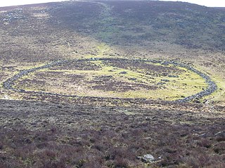
Grimspound is a late Bronze Age settlement, situated on Dartmoor in Devon, England. It consists of a set of 24 hut circles surrounded by a low stone wall. The name was first recorded by the Reverend Richard Polwhele in 1797; it was probably derived from the Anglo-Saxon god of war, Grim.

Bowerman's Nose is a stack of weathered granite on Dartmoor, Devon, England. It is situated on the northern slopes of Hayne Down, about a mile from Hound Tor and close to the village of Manaton at grid reference SX742805. It is about 21.5 feet (6.6 m) high and is the hard granite core of a former tor, standing above a 'clitter' of the blocks that have eroded and fallen from it.

Tormato is the ninth studio album by English progressive rock band Yes. It was released on 22 September 1978 on Atlantic Records, and is their last album with singer Jon Anderson and keyboardist Rick Wakeman before their departure from the group in 1980. After touring their previous album Going for the One (1977), the band entered rehearsals in London to record a follow-up. The album was affected by various problems, such as internal disputes over the direction of the music and artwork, and the departure of engineer Eddy Offord early into the sessions, resulting in the group producing the album themselves.

Derwent Edge is a Millstone Grit escarpment that lies above the Upper Derwent Valley in the Peak District National Park in the English county of Derbyshire. An Ordnance Survey column marks the highest point of the Edge at Back Tor. North of Back Tor the edge extends into Howden Edge and enters the county of South Yorkshire.
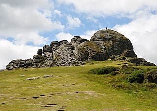
Haytor, also known as Haytor Rocks, Hay Tor, or occasionally Hey Tor, is a granite tor on the eastern edge of Dartmoor in the English county of Devon.

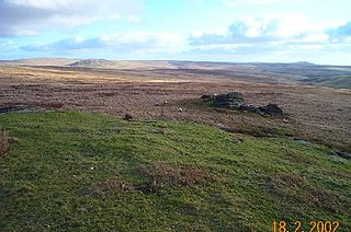
Crockern Tor is a tor in Dartmoor National Park, Devon, England. Composed of two large outcrops of rock, it is 396 metres above sea level. The lower outcrop was the open-air meeting place of the Stannary Convocation of Devon from the early 14th century until the first half of the 18th century. On Parliament Rock, pictured here, the Lord Warden of the Great Court of the Devon Tinners supposedly sat during meetings of the Court. The location of the tor is just to the NE of Two Bridges.

The mountains and hills of England comprise very different kinds of terrain, from a mountain range which reaches almost 1,000 metres high, to several smaller areas of lower mountains, foothills and sea cliffs. Most of the major upland areas have been designated as Areas of Outstanding Natural Beauty (AONB) or national parks. The highest and most extensive areas are in the north and west, while the midlands, south-east and east of the country tend to be low-lying.

The Dartmoor crosses are a series of stone crosses found in Dartmoor National Park in the centre of Devon, England. Many of them are old navigational aids, needed because of the remoteness of the moorland and its typically bad weather. Some mark medieval routes between abbeys. Other crosses were erected as memorials, for prayer, as town or market crosses, in churchyards, and as boundary markers. The crosses were erected over a long period of time, some as recently as 100 years ago, the earliest probably almost 1,000 years ago.

Rippon Tor Rifle Range is a disused rifle range from World War II on Dartmoor, Devon, England. The range is situated southeast of the 473 m high Rippon Tor, near the village Widecombe-in-the-Moor, and close to the road between Halshanger and Cold East Cross.

Hookney Tor is a tor, situated on Dartmoor in Devon, England.

Cosdon Hill, also called Cosdon Beacon, or Cawsand Beacon, is one of the highest hills on Dartmoor, in Devon, England. It has numerous traces of prehistoric occupation.
Amicombe Hill, also known as the Devil's Dome, is a hill in North Dartmoor in the southwest English county of Devon. At 584 metres high, it is the sixth highest peak in Devon and Dartmoor.

Vixen Tor is a tor on Dartmoor, England. The tor is on private land and since 2003 access by the public has been banned, causing protests and mass trespassing by hikers and climbers.

Berra Tor is a granite tor on the south western edge of Dartmoor. It is only 132 metres above sea level so is one of the lowest tors on Dartmoor. It is quite isolated and hidden from everywhere else and is generally quite unknown. It juts out of some trees and resembles more of a rock than an outcrop on a hill, like Great Mis Tor and Yes Tor that also provide views. Its nearest settlement of size is Buckland Monachorum.

