Damselflies are flying insects of the suborder Zygoptera in the order Odonata. They are similar to dragonflies but are usually smaller and have slimmer bodies. Most species fold the wings along the body when at rest, unlike dragonflies which hold the wings flat and away from the body. Damselflies have existed since the Late Jurassic, and are found on every continent except Antarctica.
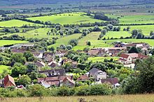
Strumpshaw Fen is a nature reserve managed by the Royal Society for the Protection of Birds (RSPB). It is situated at Strumpshaw on the River Yare in the English county of Norfolk around 6 miles (9.7 km) east of Norwich. The Buckenham Marshes RSPB reserve borders the reserve to the east.

Ouse Washes is a linear 2,513.6-hectare (6,211-acre) biological Site of Special Scientific Interest stretching from near St Ives in Cambridgeshire to Downham Market in Norfolk. It is also a Ramsar internationally important wetland site, a Special Protection Area for birds, a Special Area of Conservation and a Nature Conservation Review site, Grade I. An area of 186 hectares between March and Ely is managed by the Wildlife Trust for Bedfordshire, Cambridgeshire and Northamptonshire and another area near Chatteris is managed by the Royal Society for the Protection of Birds. The Wildfowl & Wetlands Trust manages another area near Welney.

The Cotswold Water Park is the United Kingdom's largest marl lake system, straddling the Wiltshire–Gloucestershire border, north-west of Cricklade and south of Cirencester. There are 180 lakes, spread over 42 square miles (110 km2).
Ashford Green Corridor is a green space that runs through the town of Ashford in Kent, England. The Green Corridor is made up of parks, recreation grounds and other green spaces alongside the rivers that flow through Ashford. It is a Local Nature Reserve.

Biddle Street, Yatton is a 44.8 hectare biological Site of Special Scientific Interest (SSSI) near the village of Yatton in North Somerset, notified in 1994.

Tickenham, Nailsea and Kenn Moors SSSI is a 129.4 hectare biological Site of Special Scientific Interest between Tickenham, Nailsea and Kenn on the North Somerset Levels, notified in 1995.

Catcott, Edington and Chilton Moors SSSI is a 1083 hectare biological Site of Special Scientific Interest in Somerset, England notified in 1967. It is close to the villages of Edington and Catcott.

Langmead and Weston Level is a 168.8 hectare biological Site of Special Scientific Interest in Somerset, notified in 1991.

Tealham and Tadham Moors is a 917.6 hectare biological Site of Special Scientific Interest south of Wedmore in Somerset, notified in 1985.

West Sedgemoor or West Sedge Moor is an area of the Somerset Levels, in Somerset, England, around 8 miles east of Taunton, which approximately coincides with the West Sedgemoor biological Site of Special Scientific Interest, a 1,016 hectare site notified as an SSSI in 1983. It is a flat, low-lying area of fields and meadows separated by water-filled rhynes and ditches. It is subject to controlled flooding in winter. It is drained by the River Parrett.

Laduviken is a lake in Norra Djurgården, a semi-rural area in north-eastern Stockholm, Sweden, forming part of the Royal National City Park. It is one of six lakes in Djurgården, the others being: Lillsjön, Uggleviken, Isbladskärret, Lappkärret, and Spegeldammen.

The Aammiq Wetland is the largest remaining freshwater wetland in Lebanon, a remnant of much more extensive marshes and lakes that once existed in the Bekaa Valley. It has been designated an Important Bird Area in the Middle East, is included in the Directory of Wetlands in the Middle East, was declared Ramsar Convention site number 978 in 1999, and most recently (2005) was designated, with Al Shouf Cedar Nature Reserve, a “Biosphere reserve” by UNESCO.

Moorlinch is a village and civil parish where the Polden Hills meet the Somerset Levels in Somerset, England.

The Turnford and Cheshunt Pits is a biological Site of Special Scientific Interest near Cheshunt in Hertfordshire and Essex and covers a total of 428.17 acres. It is part of the Lee Valley Special Protection Area.
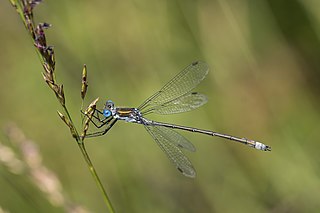
Lestes sponsa is a damselfly with a wide Palaearctic distribution. It is known commonly as the emerald damselfly or common spreadwing. Both males and females have a metallic green colour and brown wing spots. It resides near pools with aquatic plants. When resting its wings are usually half opened.

Lestes dryas is a species of damselfly in the family Lestidae, the spreadwings. Its common names include emerald spreadwing, scarce emerald damselfly and robust spreadwing. An alternate name in Ireland is the turlough spreadwing.

Chalcolestes viridis, formerly Lestes viridis, is a damselfly of the family Lestidae. It has a metallic green body and at rest it holds its wings away from its body. Its common name is the willow emerald damselfly, the green emerald damselfly, or the western willow spreadwing. It has an elongated abdomen and pale brown spots on its wings and resides in areas of still water with overhanging trees.

Pennsylvania Fields, Sedbury is a 27.03-hectare (66.8-acre) biological Site of Special Scientific Interest in Gloucestershire, notified in 1985.