
The A303 is a trunk road in southern England, running between Basingstoke in Hampshire and Honiton in Devon via Stonehenge. Connecting the M3 and the A30, it is part of one of the main routes from London to Devon and Cornwall. It is a primary A road throughout its length, passing through five counties.

The South Downs are a range of chalk hills in the south-eastern coastal counties of England that extends for about 260 sq mi (670 km2) across the south-eastern coastal counties of England from the Itchen valley of Hampshire in the west to Beachy Head, in the Eastbourne Downland Estate, East Sussex, in the east. The Downs are bounded on the northern side by a steep escarpment, from whose crest there are extensive views northwards across the Weald. The South Downs National Park forms a much larger area than the chalk range of the South Downs, and includes large parts of the Weald.

Hemyock is a village and civil parish in Devon, England. It is about 8 miles north-west of Honiton and 5 miles (8 km) south of the Somerset town of Wellington. The 2011 Census recorded the parish's population as 1,519. Hemyock is part of the electoral ward of Upper Culm. The population of this ward at the above census was 4,039. The River Culm flows through Hemyock. Hemyock was the former home of the St Ivel dairy processing plant, formerly where the butter-spreads 'St Ivel Gold' and 'Utterly-Butterly' were produced before being moved to a factory in the north of England.

The Blackdown Hills National Landscape is a National Landscape along the Somerset-Devon border in south-western England, which were designated in 1991 as an Area of Outstanding Natural Beauty (AONB). In November 2023, it has become 'Blackdown Hills National Landscape' The area encompasses a set of hills of the same name.

Pitminster is a village and civil parish in Somerset, England, situated 4 miles (6.4 km) south of Taunton. The parish has a population of 956. The parish also includes the villages of Angersleigh, Blagdon Hill and Staplehay. The village of Blagdon is now officially known as Blagdon Hill to distinguish it from Blagdon in North Somerset. Hillside hamlets in the parish comprise Feltham and Woodram, those on the lower plain in the north are Sellicks Green which is contiguous with Blagdon Hill, Duddlestone and Poundisford.

Buckland St Mary is a village and parish in Somerset, England, situated 6 miles (9.7 km) to the west of Ilminster and 8 miles (12.9 km) south of Taunton in the South Somerset district, close to the A303. The village has a population of 521. The parish is within the Blackdown Hills Area of Outstanding Natural Beauty and includes the hamlet of Birchwood.

Combe St Nicholas is a village and parish in Somerset, England, situated 2 miles (3.2 km) northwest of Chard and 10 miles (16 km) from Taunton in the South Somerset district on the edge of the Blackdown Hills Area of Outstanding Natural Beauty. The parish, which includes Wadeford and Scrapton, has a population of 1,373.

Somerset is a rural county in the southwest of England, covering 4,171 square kilometres (1,610 sq mi). It is bounded on the north-west by the Bristol Channel, on the north by Bristol and Gloucestershire, on the north-east by Wiltshire, on the south-east by Dorset, and on the south west and west by Devon. It has broad central plains with several ranges of low hills. The landscape divides into four main geological sections from the Silurian through the Devonian and Carboniferous to the Permian which influence the landscape, together with water-related features.

Blackdown, or Black Down, summit elevation 279.7 metres (918 ft) AMSL, is the highest point in both the historic county of Sussex and the South Downs National Park. It is one of the highest points in the south east of England, exceeded by Walbury Hill, Leith Hill and Pilot Hill. Blackdown is protected as part of the South Downs National Park.

Black Down and Sampford Commons is a 155.2-hectare (384-acre) biological Site of Special Scientific Interest in Devon and Somerset, notified in 1952.
Deadman is a 28.8 hectare biological Site of Special Scientific Interest on the edge of the Blackdown Hills, near Buckland St Mary 5 miles (8.0 km) south of Taunton in Somerset, notified in 1987.
Long Lye Meadow is a 3.3 hectare biological Site of Special Scientific Interest at Buckland St Mary in the Blackdown Hills, Somerset, notified in 2002.

Prior's Park & Adcombe Wood is a 103.6 hectare biological Site of Special Scientific Interest south of Pitminster in Somerset, notified in 1952.
Ringdown is a 4.0 hectare (9.9 acre) biological Site of Special Scientific Interest west of Burnworthy in the Blackdown Hills of Somerset, notified in 1990.

Ruttersleigh is a 97 hectares biological Site of Special Scientific Interest between Buckland St Mary and Staple Fitzpaine on the north-facing slope of the Blackdown Hills. in Somerset, notified in 1991.
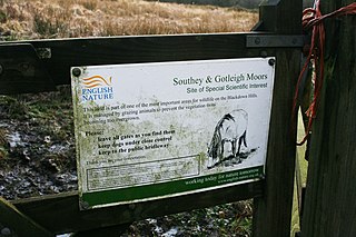
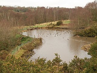
Southey and Gotleigh Moors is an 81.3 hectare biological Site of Special Scientific Interest on the Blackdown Hills in Somerset, notified in 1988.

Castle Neroche is a Norman motte-and-bailey castle on the site of an earlier hill fort in the parish of Curland, near Staple Fitzpaine, Somerset, England. It is a Scheduled Ancient Monument.

Blackdown is a small village in western Dorset, England; situated 7 miles (11 km) west of Beaminster. With the creation of the new Dorset Council, Blackdown is now part of the new Marshwood Vale Ward. The local travel links are located 5 miles (8.0 km) from the village to Crewkerne railway station and 25 miles (40 km) to Exeter International Airport. The main road through the village is the B3165, connecting Blackdown and Lyme Regis. The village has a population of 128 according to the 2001 Census. The village and surrounding area makes up the Blackdown ward of the Broadwindsor Group Parish Council which besides the few houses in Blackdown includes Kittwhistle, Templeman's Ash (part), Laymore (part), Coles Cross, Causeway Lane, Venn, Southcoombe, Stoney Knapp, Schoolhouse Lane, Speckets Lane, Racedown, Cockpit, Horn Ash, Berechapel, two houses in Synderford, some houses in Birdsmoregate including the old Rose & Crown Public House now a private residence. The area is split between many postcodes partly due to the County boundary being realigned in the 1960s. Residents have postcodes with the main town as either Beaminster, Bridport, Crewkerne or Chard. Divisions also arise within telephone exchange areas, the BT phone box was removed from the centre of Blackdown in March 2017. Water services are provided by either South West Water or Wessex Water.

Iberia Flight 062 was a twin-engined Sud Aviation Caravelle registered EC-BDD operating a scheduled flight from Málaga Airport, Spain, to London Heathrow Airport. While on approach to Heathrow on 4 November 1967, the Caravelle descended far below the flight level assigned to it and flew into the southern slope of Blackdown Hill in West Sussex, killing all 37 on board.

The county of Somerset is in South West England, bordered by the Bristol Channel and the counties of Bristol and Gloucestershire to the north, and Wiltshire to the east, Dorset to the south, and Devon to the west. The climate, influenced by its proximity to the Atlantic Ocean and the prevailing westerly winds, tends to be mild, damp and windy.
