
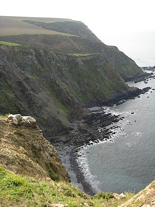
Exmoor is loosely defined as an area of hilly open moorland in west Somerset and north Devon in South West England. It is named after the River Exe, the source of which is situated in the centre of the area, two miles north-west of Simonsbath. Exmoor is more precisely defined as the area of the former ancient royal hunting forest, also called Exmoor, which was officially surveyed 1815–1818 as 18,810 acres (7,610 ha) in extent. The moor has given its name to a National Park, which includes the Brendon Hills, the East Lyn Valley, the Vale of Porlock and 55 km (34 mi) of the Bristol Channel coast. The total area of the Exmoor National Park is 692.8 km2 (267.5 sq mi), of which 71% is in Somerset and 29% in Devon.

Moorland or moor is a type of habitat found in upland areas in temperate grasslands, savannas, and shrublands and montane grasslands and shrublands biomes, characterised by low-growing vegetation on acidic soils. Moorland, nowadays, generally means uncultivated hill land, but also includes low-lying wetlands. It is closely related to heath, although experts disagree on what precisely distinguishes these types of vegetation. Generally, moor refers to highland and high rainfall zones, whereas heath refers to lowland zones which are more likely to be the result of human activity.

Dulverton is a town and civil parish in west Somerset, England, near the border with Devon. The town had a population of 1,408 at the 2011 Census. The parish includes the hamlets of Battleton and Ashwick which is located approximately 4 miles (6.4 km) north west of Dulverton.

Dunster is a village and civil parish in Somerset, England, within the north-eastern boundary of Exmoor National Park. It lies on the Bristol Channel 2.5 miles (4 km) southeast of Minehead and 20 miles (32 km) northwest of Taunton. At the 2011 Census, it had a population of 817.

The Blackdown Hills, or Blackdowns, are a range of hills along the Somerset-Devon border in south-western England. The plateau is dominated by hard chert bands of Upper Greensand with some remnants of chalk, and is cut through by river valleys.

Brushford is a village and civil parish 2 miles (3.2 km) south of Dulverton and 12 miles (19 km) north of Tiverton in Devon, in the Somerset West and Taunton district of Somerset, England. According to the 2001 census, it had a population of 535 in 243 households, reducing to 519 at the 2011 Census. It covers an area of 1,149 hectares (11 km2) of which 3 hectares (0.030 km2) is within the Exmoor National Park.

Somerset is a rural county in the southwest of England, covering 4,171 square kilometres (1,610 sq mi). It is bounded on the north-west by the Bristol Channel, on the north by Bristol and Gloucestershire, on the north-east by Wiltshire, on the south-east by Dorset, and on the south west and west by Devon. It has broad central plains with several ranges of low hills. The landscape divides into four main geological sections from the Silurian through the Devonian and Carboniferous to the Permian which influence the landscape, together with water-related features.
Ansty and Staplefield, previously Cuckfield Rural, is a civil parish in the Mid Sussex District of West Sussex, England, covering an area from the north-west side of Burgess Hill, the whole lying around but mostly to the west of Cuckfield civil parish, from which it was created in 1894 under the Local Government Act 1894. It includes the settlements of Ansty in the south, Staplefield to the north-west and Brook Street to the north-east. It is the largest civil parish in West Sussex, covering an area of 3,869 hectares (14.94 sq mi), and has a population of 1574, increasing to 1,756 at the 2011 Census.

Brendon is a village and former civil parish, now in the parish of Brendon and Countisbury, in the North Devon district, in the county of Devon, England. It is close to the border with Somerset within the Exmoor National Park, the village is 1.5 miles (2.4 km) southeast of Lynton and 15 miles (24 km) west of Minehead in the East Lyn Valley. It is located just off the A39 and is on two long distance footpaths, the Coleridge Way and the Samaritans Way South West. The Church of St Brendon is 2 mi (3 km) from the village and was built in 1738, possibly with building material brought from another site. In 2001 the parish had a population of 159.

Barle Valley is a 1,540 acres (620 ha) Site of Special Scientific Interest within Exmoor National Park, situated in the counties of Devon and Somerset through which the River Barle flows. It was notified in its current form under the Wildlife and Countryside Act in 1988. The site includes the Somerset Wildlife Trust's Mounsey Wood Nature Reserve and the Knaplock and North Barton SSSI which has been notified since 1954.

Exmoor Coastal Heaths is a 1758.3 hectare biological Site of Special Scientific Interest in Devon and Somerset, notified in 1994.

North Exmoor is a 12,005.3-hectare (29,666-acre) biological Site of Special Scientific Interest (SSSI) in Devon and Somerset, notified in 1954.
Oare is a village and civil parish on Oare Water on Exmoor in the Somerset West and Taunton district of Somerset, England. It is located 6 miles (10 km) east of Lynton and the parish includes the hamlet of Oareford and the village of Culbone which contains its own tiny church.

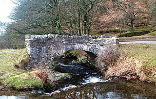
Simonsbath is a small village high on Exmoor in the English county of Somerset. It is the principal settlement in the Exmoor civil parish, which is the largest and most sparsely populated civil parish on Exmoor, covering nearly 32 square miles (83 km2) but with a population, at the time of the 2001 census, of 203 in 78 households, reducing to 156 at the 2011 census. The River Exe rises from a valley to the north, and the River Barle runs through the village and is crossed by a triple-arched medieval bridge that was extensively repaired after floods in 1952.

The county of Somerset is in South West England, bordered by the Bristol Channel and the counties of Bristol and Gloucestershire to the north, and Wiltshire to the east, Dorset to the south, and Devon to the west. The climate, influenced by its proximity to the Atlantic Ocean and the prevailing westerly winds, tends to be mild, damp and windy.

Molland is a small village, civil parish, dual ecclesiastical parish with Knowstone, located in the foothills of Exmoor in Devon, England. It lies within the North Devon local government district. At the time of the 2001 Census, the village had 203 inhabitants. Molland was first referenced as the Manor of Molland in the Domesday Book. The village contains a church dating back to the 1400s.
Steeple Point to Marsland Mouth is a coastal Site of Special Scientific Interest (SSSI) in Cornwall, England, UK, noted for its biological characteristics.

North Devon's Biosphere Reserve is a UNESCO biosphere reserve in North Devon. It covers 55 square miles (140 km2) and is centred on Braunton Burrows, the largest sand dune system (psammosere) in England. The boundaries of the reserve follow the edges of the conjoined catchment basin of the Rivers Taw and the Torridge and stretch out to sea to include the island of Lundy. The biosphere reserve is primarily lowland farmland, and includes many protected sites including 63 Sites of Special Scientific Interest which protect habitats such as culm grassland and broadleaved woodlands. The most populous settlements in its buffer area are Barnstaple, Bideford, Northam, Ilfracombe, and Okehampton.

The Exmoor Group is a late Devonian to early Carboniferous lithostratigraphic group in southwest England whose outcrop extends from Croyde in north Devon east across Exmoor to Minehead in west Somerset. The group comprises the following formations :

Withypool Stone Circle, also known as Withypool Hill Stone Circle, is a stone circle located on the Exmoor moorland, near the village of Withypool in the southwestern English county of Somerset. The ring is part of a tradition of stone circle construction that spread throughout much of Britain, Ireland, and Brittany during the Late Neolithic and Early Bronze Age, over a period between 3300 and 900 BCE. The purpose of such monuments is unknown, although archaeologists speculate that the stones represented supernatural entities for the circle's builders.

