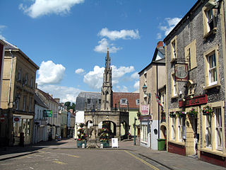
Shepton Mallet is a market town and civil parish in Somerset, England, some 16 miles southwest of Bath, 18 miles south of Bristol and five miles east of Wells. It had an estimated population of 10,810 in 2019. Mendip District Council was based there. The Mendip Hills lie to the north and the River Sheppey runs through the town, as does the route of the Fosse Way, the main Roman road between north-east and south-west England. There is evidence of Roman settlement. Its listed buildings include a medieval parish church. Shepton Mallet Prison was England's oldest, but closed in March 2013. The medieval wool trade gave way to trades such as brewing in the 18th century. It remains noted for cider production. It is the closest town to the Glastonbury Festival and nearby the Royal Bath and West of England Society showground.

Gordano is an area of North Somerset, in England. It has been designated as a National Nature Reserve.

Windsor Hill is a 61.8-hectare (153-acre) biological Site of Special Scientific Interest in Princes Risborough in Buckinghamshire. It lies within the Chilterns Area of Outstanding Natural Beauty, and it is featured in the Nature Conservation Review. A small part is managed by the Berkshire, Buckinghamshire and Oxfordshire Wildlife Trust, and access to this area requires a permit.

The North Somerset Levels is a coastal plain, an expanse of low-lying flat ground, which occupies an area between Weston-super-Mare and Bristol in North Somerset, England. The River Banwell, River Kenn, River Yeo and Land Yeo are the three principal rivers draining the area.
Yanal Bog is a 1.6 hectare biological Site of Special Scientific Interest on the southern edge of the North Somerset Levels, just north of the village of Sandford, North Somerset. It was notified as an SSSI in 1988.

Long Dole Wood and Meadows SSSI is a 9.8 hectares biological Site of Special Scientific Interest (SSSI) between the villages of Farrington Gurney and Hinton Blewitt in Bath and North East Somerset, notified in 1987.

Max Bog is a 10.6 hectare biological Site of Special Scientific Interest in North Somerset, notified in 1988.
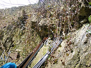
Hobbs Quarry is a 0.5 hectare geological Site of Special Scientific Interest near Shepton Mallet on the Mendip Hills in Somerset, notified in 1984.
Cook's Wood Quarry also known as Holcombe Quarry is a 0.8-hectare (2.0-acre) geological Site of Special Scientific Interest near Stoke St Michael on the Mendip Hills in Somerset, notified in 1988.

Windsor Hill Quarry is a 0.8 hectare geological Site of Special Scientific Interest near Shepton Mallet on the Mendip Hills in Somerset, adjacent to the Windsor Hill Marsh biological Site of Special Scientific Interest. It was notified in 1971.

Viaduct Quarry is a 0.3 hectare geological Site of Special Scientific Interest near Shepton Mallet on the Mendip Hills in Somerset, notified in 1984.
Shepton Montague Railway Cutting is a 1.61 hectare geological Site of Special Scientific Interest at Shepton Montague in Somerset, notified in 1992.
Maes Down is a 0.2 hectare geological Site of Special Scientific Interest between Shepton Mallet and Stoney Stratton in Somerset, notified in 1985. It is a Geological Conservation Review site.

Lambert's Castle is an Iron Age hillfort in the county of Dorset in southwest England. Since 1981 it has been designated as a Site of Special Scientific Interest (SSSI) on account of its geology, archaeology and ecology. The hillfort is designated a scheduled monument together with a bowl barrow, the sites of a post-medieval fair and a telegraph station. The site was on the Heritage at Risk Register but was removed in 2022 as a result of the Hillforts and Habitats Project.

Stoke St Michael is a village and civil parish on the Mendip Hills 4 miles (6.4 km) north east of Shepton Mallet, and 8 miles (12.9 km) west of Frome, in the Mendip district of Somerset, England.

Chilton Polden is a rural village and civil parish, situated close to Edington on the Somerset Levels to the north of the Polden Hills in Somerset, England.

Pow Hill Bog is a Site of Special Scientific Interest in the Wear Valley district of County Durham, England. It lies alongside Derwent Reservoir, approximately 2 km north-west of the village of Edmundbyers and adjacent to the Edmundbyers Common portion of the Muggleswick, Stanhope and Edmundbyers Commons and Blanchland Moor SSSI.

Cefn Blaenau is a 23-hectare Site of Special Scientific Interest in a small upland valley in Carmarthen and Dinefwr, Wales. It was designated an SSSI in 1989, primarily for its flush and spring vegetation as well as the diverse mosaic of unimproved pasture, ‘ffridd’ land, marshy grassland, wet heath, acid grassland, broadleaved woodland, streams, and small rock outcrops. These habitats, which are well represented at this site, have been greatly reduced in north Carmarthenshire due to land improvement, agricultural intensification, and afforestation. Only about 140 hectares of flush and spring vegetation remain in the county.

The Lower Moors is a wetland between Hugh Town and Old Town Bay on St Mary's, the largest island in the Isles of Scilly. The Isles of Scilly are an archipelago off the southwestern tip of the Cornish peninsula of Great Britain.
Alnmouth Saltmarsh and Dunes is a Site of Special Scientific Interest (SSSI) in Northumberland, England. It is the largest saltflat on the north-east coast, located on the south bank of the River Aln estuary, and notable for the varied plant community found on the interface between the saltflats and the dunes. It overlaps with and forms part of the much larger Northumberland Shore SSSI.

