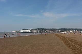
Weston-super-Mare, also known as Weston, is a seaside town in North Somerset, England. It lies by the Bristol Channel 20 miles (32 km) south west of Bristol between Worlebury Hill and Bleadon Hill. It includes the suburbs of Mead Vale, Milton, Oldmixon, West Wick, Worlebury, Uphill and Worle. Its population at the 2011 census was 76,143. Since 1983, Weston has been twinned with Hildesheim in Germany.

Nailsea is a town in Somerset, England, 8 miles (13 km) southwest of Bristol, and 11 miles (18 km) northeast of Weston-super-Mare. The nearest village is Backwell, which lies south of Nailsea on the opposite side of the Bristol to Exeter railway line. Nailsea had a population of 15,630 in the 2011 Census.

Tickenham is a village and civil parish near Clevedon and Nailsea in North Somerset, England. The parish has a population of 910. It has a primary school and a village hall, but no shops, although it formerly had a post office.

Bishop Sutton is a village on the northern slopes of the Mendip Hills, within the affluent Chew Valley in Somerset. It lies east of Chew Valley Lake and north east of the Mendip Hills, approximately ten miles south of Bristol on the A368, Weston-super-Mare to Bath road between West Harptree and Chelwood. Bishop Sutton and the neighbouring village of Stowey form the civil parish of Stowey Sutton.
Congrove Field and The Tumps is a is a 14.2 hectares biological Site of Special Scientific Interest (SSSI) on Lansdown Hill, north of Bath in Bath and North East Somerset, notified in 1991.

Tickenham, Nailsea and Kenn Moors SSSI is a 129.4 hectare biological Site of Special Scientific Interest between Tickenham, Nailsea and Kenn on the North Somerset Levels, notified in 1995.

Chancellor's Farm is a 34.2-hectare biological Site of Special Scientific Interest just north of Priddy in the Mendip Hills, Somerset, notified in 1984.

Kenn is a small village and civil parish in the county of Somerset, England. It falls within the area of the North Somerset unitary authority. It lies on the B3133 road near Clevedon in the North Somerset Levels. The parish has a population of 431.
Lang's Farm is a 7.5 hectare biological Site of Special Scientific Interest between Oake and Bradford on Tone in Somerset, notified in 1990.
Grove Farm is a 36.5 hectare biological Site of Special Scientific Interest in Somerset, notified in 1989.
Woolhayes Farm is a 13.2 hectare biological Site of Special Scientific Interest east of Combe St Nicholas in Somerset, notified in 1992.

Hutton is a village and civil parish in Somerset, England. The parish, which has a population of 2,582, is within the unitary authority of North Somerset and located on the western edge of the Mendip Hills, close to Weston-super-Mare.

Puxton is a village and civil parish, 5 miles (8.0 km) north west of Axbridge in the unitary authority of North Somerset within the ceremonial county of Somerset, England.

Muchelney is a clustered village and civil parish in Somerset, England, extending for 3 kilometres (1.9 mi) from the south bank of the River Parrett and that has a clustered centre. This is 1 mile (1.6 km) south of Huish and Langport and 4 miles (6.4 km) south west of Somerton in the South Somerset district. Its elevations range from 8 to 12 metres AOD. Muchelney has some orchards and a copse of remaining woodland in the centre-south covering between 2 and 5% of the land.

Banwell is a village and civil parish on the River Banwell in the North Somerset district of Somerset, England. Its population was 2,919 according to the 2011 census.
Holford is a village and civil parish in West Somerset within the Quantock Hills Area of Outstanding Natural Beauty. It is located about 10 miles (16 km) west of Bridgwater and 6 miles (10 km) east of Williton, with a population of 392. The village is on the Quantock Greenway and Coleridge Way footpaths. The parish includes the village of Dodington.

Marion Station, also known as Marion, is an unincorporated community in Somerset County, Maryland, United States. It is located at the northern intersection of Maryland routes 413 and 667. After the arrival of the Pennsylvania Railroad arm known as the "Eastern Shore Railroad" toward Crisfield in 1866, Marion was locally hailed as the "strawberry capital of the world". After the trains stopped coming it went into decline, with some sources even hailing it as a ghost town.

Sand Point in Somerset, England, is the peninsula stretching out from Middle Hope, an 84.1-hectare (208-acre) biological and geological Site of Special Scientific Interest. It lies to the north of the village of Kewstoke, and the stretch of coastline called Sand Bay north of the town of Weston-super-Mare. On a clear day it commands views over Flat Holm, of the Bristol Channel, South Wales, Clevedon, the Second Severn Crossing and the Severn Bridge. A line drawn between Sand Point and Lavernock Point in South Wales marks the lower limit of the Severn Estuary and the start of the Bristol Channel.

