
The Blackdown Hills are a range of hills along the Somerset-Devon border in south-western England, which were designated an Area of Outstanding Natural Beauty (AONB) in 1991.
Bradford-on-Tone is a village and civil parish in Wellington, Somerset, England, situated on the River Tone 4 miles (6.4 km) south west of Taunton in the Somerset West and Taunton district. The parish, which includes Tone Green and Hele, has a population of 622.
Chipstable is a village and civil parish in Somerset, England, situated beside Heydon Hill 10 miles (16.1 km) west of Taunton in the Somerset West and Taunton district. The parish has a population of 309.

Oake is a village and civil parish in Somerset, England, situated 5 miles (8.0 km) west of Taunton in the Somerset West and Taunton district. The village has a population of 765.

Ruishton is a village and civil parish in Somerset, England, situated on the River Tone and A358 road 2 miles (3.2 km) east of Taunton in the Somerset West and Taunton district. The village has a population of 1,473. The parish includes the hamlet of Henlade.

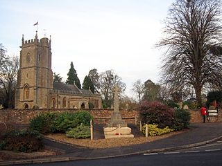
Stawley is a village and civil parish in Somerset, England, situated 10 miles (16.1 km) west of Taunton in the Somerset West and Taunton district. The parish has a population of 279 and includes the village of Kittisford and the hamlets of Appley, Greenham and Tracebridge.

Chilton Cantelo is a village and parish in Somerset, England, situated on the River Yeo 5 miles (8 km) north of Yeovil and 4 miles (6 km) east of Ilchester in the South Somerset district. The village has a population of 445. The parish also includes the village of Ashington.

Combe St Nicholas is a village and parish in Somerset, England, situated 2 miles (3.2 km) northwest of Chard and 10 miles (16 km) from Taunton in the South Somerset district on the edge of the Blackdown Hills Area of Outstanding Natural Beauty. The parish, which includes Wadeford and Scrapton, has a population of 1,373.

Mudford is a village and parish in Somerset, England, situated 3 miles (4.8 km) from Yeovil in the South Somerset district on the River Yeo. The village has a population of 696. The parish includes the hamlets of Mudford Sock, West Mudford and Up Mudford.

Bishop Sutton is a village on the northern slopes of the Mendip Hills, within the affluent Chew Valley in Somerset. It lies east of Chew Valley Lake and north east of the Mendip Hills, approximately ten miles south of Bristol on the A368, Weston-super-Mare to Bath road between West Harptree and Chelwood. Bishop Sutton and the neighbouring village of Stowey form the civil parish of Stowey Sutton.

Stowey is a small village within the Chew Valley in Somerset, England. It lies south of Chew Valley Lake and north of the Mendip Hills, approximately 10 miles (16 km) south of Bristol on the A368 road Weston-super-Mare to Bath. Stowey and its neighbouring and larger village, Bishop Sutton, form the civil parish of Stowey Sutton.

Chancellor's Farm is a 34.2-hectare biological Site of Special Scientific Interest just north of Priddy in the Mendip Hills, Somerset, notified in 1984.
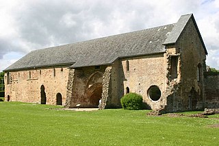
Cleeve Abbey is a medieval monastery located near the village of Washford, in Somerset, England. It is a Grade I listed building and has been scheduled as an ancient monument.
Grove Farm is a 36.5 hectare biological Site of Special Scientific Interest in Somerset, notified in 1989.

Somerset East is a town in the Blue Crane Route Local Municipality in the Eastern Cape, South Africa. It was founded by Lord Charles Somerset in 1825.

Muchelney is a clustered village and civil parish in Somerset, England, extending for 3 kilometres (1.9 mi) from the south bank of the River Parrett and that has a clustered centre. This is 1 mile (1.6 km) south of Huish and Langport and 4 miles (6.4 km) south west of Somerton in the South Somerset district. Its elevations range from 8 to 12 metres AOD. Muchelney has some orchards and a copse of remaining woodland in the centre-south covering between 2 and 5% of the land.

Stoke sub Hamdon Priory is a complex of buildings and ruins which initially formed a 14th-century college for the chantry chapel of St Nicholas, and later was the site of a farm in Stoke-sub-Hamdon, Somerset, England. The only building remaining from the college is a great hall and attached dwelling, dating from the late 15th century. The hall is designated by English Heritage as a Grade I listed building, while the outbuildings and gateway are Grade II listed. The whole site has been scheduled as an ancient monument. A number of the farm buildings are in poor condition, and have been added to the Heritage at Risk Register.

The Grade I listed buildings in Somerset, England, demonstrate the history and diversity of its architecture. The ceremonial county of Somerset consists of a non-metropolitan county, administered by Somerset County Council, which is divided into five districts, and two unitary authorities. The districts of Somerset are West Somerset, South Somerset, Taunton Deane, Mendip and Sedgemoor. The two administratively independent unitary authorities, which were established on 1 April 1996 following the breakup of the county of Avon, are North Somerset and Bath and North East Somerset. These unitary authorities include areas that were once part of Somerset before the creation of Avon in 1974.
Drove Cottage Henge is a Scheduled Ancient Monument in the Priddy parish of Somerset, England. It is located 370 metres (1,210 ft) north of Drove Cottage. The site is a ceremonial Neolithic location. Since this henge is one of only around 80 henges throughout England, it is considered to be nationally important.

Sand Point in Somerset, England, is the peninsula stretching out from Middle Hope, an 84.1-hectare (208-acre) biological and geological Site of Special Scientific Interest. It lies to the north of the village of Kewstoke, and the stretch of coastline called Sand Bay north of the town of Weston-super-Mare. On a clear day it commands views over Flat Holm, of the Bristol Channel, South Wales, Clevedon, the Second Severn Crossing and the Severn Bridge. A line drawn between Sand Point and Lavernock Point in South Wales marks the lower limit of the Severn Estuary and the start of the Bristol Channel.
