Grid reference

Last updated
A typical map with grid lines Fictional Map 1.jpg
A typical map with grid lines

Grid references define locations in maps using Cartesian coordinates. Grid lines on maps define the coordinate system, and are numbered to provide a unique reference to each location on the map. This reference is normally based on projected eastings and northings.

Contents

Types

Grid systems vary, but the most common is a square grid with grid lines intersecting each other at right angles and numbered sequentially from the origin at the bottom left of the map. The grid numbers on the east-west (horizontal) axis are called Eastings, and the grid numbers on the north-south (vertical) axis are called Northings.

Numerical grid references consist of an even number of digits. Eastings are written before Northings. Thus in a 6 digit grid reference 123456, the Easting component is 123 and the Northing component is 456, i.e. if the smallest unit is 100 metres, it refers to a point 12.3 km east and 45.6 km north from the origin.

Grids may be arbitrary, or can be based on specific distances, for example some maps use a one-kilometre square grid spacing.

A grid reference locates a unique square region on the map. The precision of location varies, for example a simple town plan may use a simple grid system with single letters for Eastings and single numbers for Northings. A grid reference in this system, such as 'H3', locates a particular square rather than a single point.

Points can be located by grid references on maps that use a standard system for Eastings and Northings, such as the Universal Transverse Mercator used worldwide, or the Ordnance Survey National Grid used by Ordnance Survey in the UK. These points can then be located by someone else using grid references, even if using maps of a different scale.

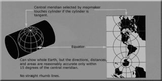
In the Universal Transverse Mercator (UTM) system, grid reference is given by three numbers: zone, easting and northing. In the UTM system, the Earth is divided into 60 zones. Northing values are given by the metres north, or south (in the southern hemisphere) of the equator. Easting values are established as the distance from the central meridian of a zone. The central meridian is arbitrarily set at 500,000 metres, to avoid negative numbers. A position 100 kilometres west of a central meridian would have an easting of 400,000 metres. Due to its popularity, and worldwide cover, the UTM system is used worldwide by NATO as well as many countries, including Australia and the USA. [1]

In the United Kingdom, a proprietary grid system is used. In Ordnance Survey maps, each Easting and Northing grid line is given a two-digit code, based on the British national grid reference system with an origin point just off the southwest coast of the United Kingdom. The area is divided into 100 km squares, each of which is denoted by a two-letter code. Within each 100 km square, a numerical grid reference is used. Since the Eastings and Northings are one kilometre apart, a combination of a Northing and an Easting will give a four-digit grid reference describing a one-kilometre square on the ground. The convention is the grid reference numbers call out the lower-left corner of the desired square. In the example map below, the town Little Plumpton lies in the square 6901, even though the writing which labels the town is in 6802 and 6902, most of the buildings (the orange boxed symbols) are in square 6901.

The more digits added to a grid reference, the more precise the reference becomes. To locate a specific building in Little Plumpton, a further two digits are added to the four-digit reference to create a six-digit reference. The extra two digits describe a position within the 1-kilometre square. Imagine (or draw or superimpose a Romer) a further 10x10 grid within the current grid square. Any of the 100 squares in the superimposed 10×10 grid can be accurately described using a digit from 0 to 9 (with 0 0 being the bottom left square and 9 9 being the top right square).

For the church in Little Plumpton, this gives the digits 6 and 7 (6 on the left to right axis (Eastings) and 7 on the bottom to top axis (Northings). These are added to the four-figure grid reference after the two digits describing the same coordinate axis, and thus our six-figure grid reference for the church becomes 696017. This reference describes a 100-metre by 100-metre square, and not a single point, but this precision is usually sufficient for navigation purposes. The symbols on the map are not precise in any case, for example the church in the example above would be approximately 100x200 metres if the symbol was to scale, so in fact, the middle of the black square represents the map position of the real church, independently of the actual size of the church.

Grid references comprising larger numbers for greater precision could be determined using large-scale maps and an accurate Romer. This might be used in surveying but is not generally used for land navigating for walkers or cyclists, etc. The growing availability and decreasing cost of handheld GPS receivers enables determination of accurate grid references without needing a map, but it is important to know how many digits the GPS displays to avoid reading off just the first six digits. A GPS unit commonly gives a ten-digit grid reference, based on two groups of five numbers for the Easting and Northing values. Each successive increase in precision (from 6 digit to 8 digit to 10 digit) pinpoints the location more precisely by a factor of 10. Since, in the UK at least, a 6-figure grid reference identifies a square of 100-metre sides, an 8-figure reference would identify a 10-metre square, and a 10-digit reference a 1-metre square. In order to give a standard 6-figure grid reference from a 10-figure GPS readout, the 4th, 5th, 9th and 10th digits must be omitted, so it is important not to read just the first 6 digits.

See also

Related Research Articles

Geodesy The science of the geometric shape, orientation in space, and gravitational field of Earth

Geodesy is the Earth science of accurately measuring and understanding Earth's geometric shape, orientation in space and gravitational field. The field also incorporates studies of how these properties change over time and equivalent measurements for other planets. Geodynamical phenomena include crustal motion, tides and polar motion, which can be studied by designing global and national control networks, applying space and terrestrial techniques and relying on datums and coordinate systems.

Geographic coordinate system Coordinate system to specify locations on Earth

A geographic coordinate system (GCS) is a coordinate system associated with positions on Earth. A GCS can give positions:

Ordnance Survey National Grid System of geographic grid references used in Great Britain

The Ordnance Survey National Grid reference system is a system of geographic grid references used in Great Britain, distinct from latitude and longitude.

Prime meridian (Greenwich) meridian

The prime meridian is a geographical reference line that passes through the Royal Observatory, Greenwich, in London, England. It was first established by Sir George Airy in 1851, and by 1884, over two-thirds of all ships and tonnage used it as the reference meridian on their charts and maps. In October of that year, at the behest of US President Chester A. Arthur, 41 delegates from 25 nations met in Washington, D.C., United States, for the International Meridian Conference. This conference selected the meridian passing through Greenwich as the official prime meridian due to its popularity. However, France abstained from the vote, and French maps continued to use the Paris meridian for several decades. In the 18th century, London lexicographer Malachy Postlethwayt published his African maps showing the "Meridian of London" intersecting the Equator a few degrees west of the later meridian and Accra, Ghana.

The Maidenhead Locator System is a geographic co-ordinate system used by amateur radio operators to succinctly describe their locations, which replaced the deprecated QRA locator that was limited to European contacts. Its purpose is to be concise, accurate and robust in the face of interference and adverse transmission conditions. The Maidenhead Locator System can describe locations anywhere in the world.

Transverse Mercator projection The transverse Mercator projection is the transverse aspect of the standard (or Normal) Mercator projection

The transverse Mercator map projection is an adaptation of the standard Mercator projection. The transverse version is widely used in national and international mapping systems around the world, including the Universal Transverse Mercator. When paired with a suitable geodetic datum, the transverse Mercator delivers high accuracy in zones less than a few degrees in east-west extent.

Irish grid reference system System of geographic grid references used for mapping in Ireland

The Irish grid reference system is a system of geographic grid references used for paper mapping in Ireland. The Irish grid partially overlaps the British grid, and uses a similar co-ordinate system but with a meridian more suited to its westerly location.

Military Grid Reference System global coordinate reference system

The Military Grid Reference System (MGRS) is the geocoordinate standard used by NATO militaries for locating points on Earth. The MGRS is derived from the Universal Transverse Mercator (UTM) grid system and the Universal Polar Stereographic (UPS) grid system, but uses a different labeling convention. The MGRS is used as geocode for the entire Earth.

The Swiss coordinate system is a geographic coordinate system used in Switzerland and Liechtenstein for maps and surveying by the Swiss Federal Office of Topography (Swisstopo).

The Swedish grid is the coordinate system used for government maps in Sweden. RT 90 is a slightly modified version of the RT 38 from 1938.

Universal Transverse Mercator coordinate system coordinate system

The Universal Transverse Mercator (UTM) is a system for assigning coordinates to locations on the surface of the Earth. Like the traditional method of latitude and longitude, it is a horizontal position representation, which means it ignores altitude and treats the earth as a perfect ellipsoid. However, it differs from global latitude/longitude in that it divides earth into 60 zones and projects each to the plane as a basis for its coordinates. Specifying a location means specifying the zone and the x, y coordinate in that plane. The projection from spheroid to a UTM zone is some parameterization of the transverse Mercator projection. The parameters vary by nation or region or mapping system.

The World Geographic Reference System (GEOREF) is a geocode, a grid-based method of specifying locations on the surface of the Earth. GEOREF is essentially based on the geographic system of latitude and longitude, but using a simpler and more flexible notation. GEOREF was used primarily for air navigation, particularly in military or inter-service applications, but it is rarely seen today. However, GEOREF can be used with any map or chart that has latitude and longitude printed on it.

United States National Grid

The United States National Grid (USNG) is a multi-purpose location system of grid references used in the United States. It provides a nationally consistent "language of location", optimized for local applications, in a compact, user friendly format. It is similar in design to the national grid reference systems used in other countries. The USNG was adopted as a national standard by the Federal Geographic Data Committee (FGDC) of the US Government in 2001.

Irish Transverse Mercator Geographic coordinate system for Ireland

Irish Transverse Mercator (ITM) is the geographic coordinate system for Ireland. It was implemented jointly by the Ordnance Survey Ireland (OSi) and the Ordnance Survey of Northern Ireland (OSNI) in 2001. The name is derived from the Transverse Mercator projection it uses and the fact that it is optimised for the island of Ireland.

Israeli Transverse Mercator

Israeli Transverse Mercator is the new geographic coordinate system for Israel. The name is derived from the Transverse Mercator projection it uses and the fact that it is optimized for Israel. ITM has replaced the old coordinate system ICS. This coordinate system is sometimes also referred as the "New Israeli Grid". It has been use since January 1, 1994.

Israeli Cassini Soldner historical geographic coordinate system

Israeli Cassini Soldner is the old geographic coordinate system for Israel. The name is derived from the Cassini Soldner projection it uses and the fact that it is optimized for Israel. ICS has been mostly replaced by the new coordinate system Israeli Transverse Mercator (ITM), but still referenced by older books and navigation software.

Horizontal position representation

A position representation is the parameters used to express a position relative to a reference. When representing positions relative to the Earth, it is often most convenient to represent vertical position separately, and to use some other parameters to represent horizontal position. There are also several applications where only the horizontal position is of interest, this might e.g. be the case for ships and ground vehicles/cars. It is a type of geographic coordinate system.

The Cassini Grid was a grid coordinate system used on British military maps during the first half of the twentieth century, particularly during World War II. The referencing consists of square grids drawn on a Cassini projection. For a period after the war, the maps were also used by the general public. The system has been superseded by the Ordnance Survey National Grid.

Palestine grid

The British Mandate Palestine grid was the geographic coordinate system used by the Survey Department of Palestine.

The Open Location Code (OLC) is a geocode system for identifying an area anywhere on the Earth. It was developed at Google's Zürich engineering office, and released late October 2014. Location codes created by the OLC system are referred to as "plus codes".

References