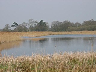
Redgrave and Lopham Fens is a 127 hectare biological Site of Special Scientific Interest between Thelnetham in Suffolk and Diss in Norfolk. It is a National Nature Reserve, a Ramsar internationally important wetland site, a Nature Conservation Review site, Grade I, and part of the Waveney and Little Ouse Valley Fens Special Area of Conservation. It is managed by the Suffolk Wildlife Trust.

The Somerset Levels are a coastal plain and wetland area of Somerset, England, running south from the Mendips to the Blackdown Hills.

Somerset Wildlife Trust is a wildlife trust covering the county of Somerset, England.

Suffolk Wildlife Trust (SWT) describes itself as the county's "nature charity – the only organisation dedicated wholly to safeguarding Suffolk's wildlife and countryside." It is a registered charity, and its headquarters is at Brooke House in Ashbocking, near Ipswich. It was founded in 1961, and is one of 46 wildlife trusts covering the Great Britain and Northern Ireland. As of March 2017, it has 13,200 members, and it manages 3,120 hectares of land in 60 nature reserves, most of which are open to the public. It had an income of £3.9 million in the year to 31 March 2017.

The Sweet Track is an ancient trackway, or causeway, in the Somerset Levels, England, named after its finder, Ray Sweet. It was built in 3807 BC and is the second-oldest timber trackway discovered in the British Isles, dating to the Neolithic. It is now known that the Sweet Track was predominantly built along the course of an earlier structure, the Post Track.
Ballynahone Bog is a raised bog, situated in County Londonderry, Northern Ireland, about 3 km south of Maghera, on low-lying ground immediately north of the Moyola River about 14 km from its mouth at Lough Neagh. It is one of the largest lowland raised bogs in Northern Ireland.

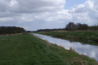
The River Brue originates in the parish of Brewham in Somerset, England, and reaches the sea some 50 kilometres (31 mi) west at Burnham-on-Sea. It originally took a different route from Glastonbury to the sea, but this was changed by Glastonbury Abbey in the twelfth century. The river provides an important drainage route for water from a low-lying area which is prone to flooding which man has tried to manage through rhynes, canals, artificial rivers and sluices for centuries.
Shapwick Heath is a 394.0-hectare biological Site of Special Scientific Interest and national nature reserve between Shapwick and Westhay in Somerset, notified in 1967. It is part of the Brue Valley Living Landscape conservation project. The project commenced in January 2009 and aims to restore, recreate and reconnect habitat. It aims to ensure that wildlife is enhanced and capable of sustaining itself in the face of climate change while guaranteeing farmers and other landowners can continue to use their land profitably. It is one of an increasing number of landscape scale conservation projects in the UK.

Street Heath is a 12.5 hectare biological Site of Special Scientific Interest 4 km west of Glastonbury in Somerset, notified in 1966. It next to the Glastonbury Canal and Ham Wall nature reserve. Street Heath has itself been designated as a Local Nature Reserve.

Westhay Moor is a 513.7-hectare (1,269-acre) biological Site of Special Scientific Interest 2.5 kilometres (1.6 mi) north-east of Westhay village and 4 kilometres (2.5 mi) from Wedmore in Somerset, England, notified in 1971. Westhay Moor is also notified as part of the Somerset Levels and Moors Special Protection Area under the EU Birds Directive and as a Ramsar site, and a National Nature Reserve.

Galton's Canal was a 1-mile 3 furlong (2.2 km) canal with one lock, crossing Westhay Moor in Somerset, England, and connecting the River Brue to the North Drain. It was operational by 1822, and ceased to be used after the 1850s.

Westhay is a village in Somerset, England. It is situated in the parish of Meare, 4 miles (6.4 km) north west of Glastonbury on the Somerset Levels, in the Mendip district.

Fulbourn Fen is a 27.3 hectare biological Site of Special Scientific Interest east of Fulbourn, Cambridgeshire. It is privately owned and managed by the Wildlife Trust for Bedfordshire, Cambridgeshire and Northamptonshire.

Ham Wall is an English wetland National Nature Reserve (NNR) 4 kilometres (2.5 mi) west of Glastonbury on the Somerset Levels. It is managed by the Royal Society for the Protection of Birds (RSPB). Since the last Ice Age, decomposing plants in the marshes of the Brue valley in Somerset have accumulated as deep layers of peat that were commercially exploited on a large scale in the twentieth century. Consumer demand eventually declined, and in 1994 the landowners, Fisons, gave their old workings to what is now Natural England, who passed the management of the 260 hectares Ham Wall section to the RSPB.

East Winch Common is a 26.1-hectare (64-acre) biological Site of Special Scientific Interest south-east of King's Lynn in Norfolk. It is common land and is managed by the Norfolk Wildlife Trust.

Foulshaw Moss is a raised bog in Cumbria, England. In 1998 it was bought by Cumbria Wildlife Trust, which has worked to reverse damage caused to the bog by drainage and afforestation. It is protected as a Site of Special Scientific Interest and as part of the Witherslack Mosses Special Area of Conservation along with two smaller bogs Meathop Moss and Nichols Moss.

Frilford Heath, Ponds and Fens is a 108.8-hectare (269-acre) biological Site of Special Scientific Interest in Frilford, west of Abingdon in Oxfordshire. An area of 3 hectares, separate from the main site is Hitchcopse Pit, a nature reserve managed by the Berkshire, Buckinghamshire and Oxfordshire Wildlife Trust.
The Avalon Marshes Partnership is a group of conservation organisations working together in the Somerset Levels. The members are Natural England,, the Royal Society for the Protection of Birds (RSPB), the Somerset Wildlife Trust the Hawk and Owl Trust, Historic England, South West Heritage Trust and the Environment Agency. Between 2012 and 2016 the scheme was supported by a Heritage Lottery Fund grant of £1,772,500 with additional investment of £920,080 from other sources. The Avalon Marshes Centre, run by Natural England, is near the Ham Wall reserve. The network of reserves and private land managed for conservation in the Avalon marshes means that wetland management can be carried out on a landscape scale.

Potter and Scarning Fens, East Dereham is a 6.2-hectare (15-acre) biological Site of Special Scientific Interest south of Dereham in Norfolk. It is part of the Norfolk Valley Fens Special Area of Conservation. Scarning Fen is a Nature Conservation Review site, Grade I, and it is managed by the Norfolk Wildlife Trust.

