
A meadow is an open habitat, or field, vegetated by grass, herbs and other non-woody plants. Meadows may be sparsely covered with trees or shrubs, as long as they maintain an open character. They may be naturally occurring or artificially created from cleared shrub or woodland. They can occur naturally under favourable conditions, but they are often maintained by humans for the production of hay, fodder or livestock. Meadow habitats, as a group, are characterized as 'semi-natural grasslands', meaning that they are largely composed of species native to the region, with only limited human intervention.
North Meadow, Cricklade is a hay meadow near the town of Cricklade, in Wiltshire, England. It is 24.6 hectares in size. It is a traditionally managed lowland hay-meadow, or lammas land, and is grazed in common between 12 August and 12 February each year, and cut for hay no earlier than 1 July. This pattern of land use and management has existed for many centuries and has resulted in the species rich grassland flora and fauna present on the site.
Thorpe Hay Meadow is a 6.4-hectare (16-acre) biological Site of Special Scientific Interest west of Staines-upon-Thames in Surrey. It is owned and managed by the Surrey Wildlife Trust.

Owston is a small village and civil parish in the Metropolitan Borough of Doncaster in rural South Yorkshire, England. Historically part of the West Riding of Yorkshire, the village is situated amongst mixed farmland and woodland 6 miles (9.7 km) north north west of Doncaster, just west of the A19. It had a population of 170 in 2001, which fell to 145 according to the 2011 Census.

Acaster South Ings is a Site of Special Scientific Interest, or SSSI, near York, England. It consists of two alluvial flood-meadows, and was designated in 1988 because it supports diverse fauna and flora, some of which is rare in the Vale of York area. One of the rarities is the tansy beetle, which feeds on the leaves of the tansy plant.

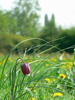
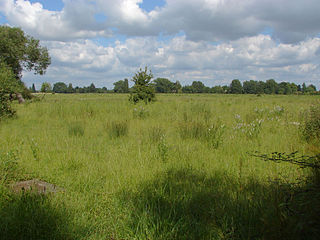
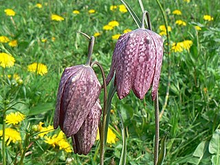
Mottey Meadows National Nature Reserve (NNR) consists of a series of alluvial flood meadows near the village of Wheaton Aston in Staffordshire, England. The meadows have been managed for hay making for many centuries. They support over 240 species of flowering plants, including the rare snake's-head fritillary.

Cornriggs Meadows is a Site of Special Scientific Interest in Upper Weardale in north-west County Durham, England. It consists of a group of fields, located in the Wear valley, 1 km north-west of the village of Cowshill. Most of the fields are maintained as hay meadows by traditional farming methods.
Far High House Meadows is a Site of Special Scientific Interest in Upper Weardale in west County Durham, England. It consists of three fields, located just south of Burnhope Reservoir, some 3 km west of the village of Ireshopeburn. Two of the fields are maintained as northern hay meadows by traditional farming methods, without re-seeding or the application of artificial fertilisers; the third is grazed as pasture.

Metfield Meadow is a 1.3 hectare biological Site of Special Scientific Interest west of Halesworth in Suffolk. It is owned and managed by Suffolk Wildlife Trust under the name Winks Meadow.
Elmlea Meadows is a 6.9-hectare (17-acre) biological Site of Special Scientific Interest in Gloucestershire, notified in 1989. The site is listed in the 'Cotswold District' Local Plan 2001-2011 as a Key Wildlife Site (KWS).

Innsworth Meadow is a 2.9-hectare (7.2-acre) biological Site of Special Scientific Interest in Gloucestershire, notified in 1979.

Upham Meadow and Summer Leasow is a 104.0-hectare (257-acre) biological Site of Special Scientific Interest on the border between Gloucestershire and Herefordshire & Worcestershire, at Twyning and near Bredon, notified in 1991.

Roding Valley Meadows is an 18.9 hectare biological Site of Special Scientific Interest in Buckhurst Hill in Essex. It is part of a 65.2 hectare Local Nature Reserve with the same name, which is owned by Epping Forest District Council and Grange Farm Trust, and managed by the Essex Wildlife Trust.
Ashdon Meadows is a 1.5 hectare biological Site of Special Scientific Interest south of Ashdon in Essex.

Major Farm Meadow is a 1.8 hectare biological Site of Special Scientific Interest south-west of Eye in Suffolk.

Lount Meadows is a 8.5 hectares biological Site of Special Scientific Interest south of Lount in Leicestershire.

Shelfanger Meadows is a 10.3-hectare (25-acre) biological Site of Special Scientific Interest north of Diss in Norfolk.

Quarry Moor is a Site of Special Scientific Interest, or SSSI, at the south edge of Ripon, North Yorkshire, England, and adjacent to the A61 road. It contains an outcrop of Magnesian Limestone, exposed by former quarrying. 255 million years ago this limestone was the peripheral sediment of a tropical sea. The land was donated in 1945 to the people of Ripon by the town's mayor, Alderman Thomas Fowler Spence, a varnish manufacturer. The land was notified as an SSSI in 1986 because its calcareous grassland supported a large diversity of plant species. The site features a Schedule 8 protected plant, thistle broomrape. The land is protected as a nature reserve, and it is also managed as a recreational area. Therefore, its calcareous grass area is fenced off for protection and study, but it also contains a car park, information signs, a children's play area, accessible paths, benches, and dog waste bins.

Bishop Monkton Ings is a Site of Special Scientific Interest, or SSSI, situated east of Bishop Monkton village in North Yorkshire, England. It consists mostly of marshy, calcareous grassland, with some broadleaved woodland, and some fen alongside the two watercourses which run through the site. This varied wetland forms a habitat for a variety of plants, including the semi-parasitic marsh lousewort (Pedicularis palustris).

Iffley Meadows is a 36.1-hectare (89-acre) biological Site of Special Scientific Interest in Oxford in Oxfordshire. It is owned by Oxford City Council and managed by the Berkshire, Buckinghamshire and Oxfordshire Wildlife Trust
