| Site of Special Scientific Interest | |
 | |
 Location within Somerset | |
| Area of Search | Somerset |
|---|---|
| Grid reference | ST100235 |
| Coordinates | 51°00′14″N3°17′03″W / 51.00382°N 3.28407°W Coordinates: 51°00′14″N3°17′03″W / 51.00382°N 3.28407°W |
| Interest | Biological |
| Area | 95.4 hectares (0.954 km2; 0.368 sq mi) |
| Notification | 1966 |
| Natural England website | |
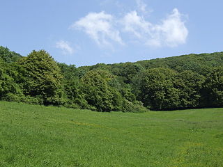
Langford Heathfield (grid reference ST100235 ) is a 95.4 hectare (235.7 acre) biological Site of Special Scientific Interest at Langford Budville, 3 km (1.9 mi) north west of Wellington in Somerset, notified in 1966.

The Ordnance Survey National Grid reference system is a system of geographic grid references used in Great Britain, distinct from latitude and longitude. It is often called British National Grid (BNG).

The hectare is an SI accepted metric system unit of area equal to a square with 100-metre sides, or 10,000 m2, and is primarily used in the measurement of land. There are 100 hectares in one square kilometre. An acre is about 0.405 hectare and one hectare contains about 2.47 acres.

Langford Budville is a village and civil parish in Somerset, England, situated near the River Tone 2 miles (3.2 km) north-west of Wellington, 4.5 miles (7.2 km) from Wiveliscombe and 6 miles (9.7 km) west of Taunton in the Taunton Deane district. The parish includes the hamlets of Bindon, Lower Chipley, Lower Wellisford, Ramsey and Runnington. The parish has a population of 535.
Most of this Somerset Wildlife Trust reserve was purchased in 1982 with Coram’s wood and Lucas’s Copse added in 1985. The purchases were generously assisted by World Wide Fund for Nature, the Countryside Agency, English Nature, Taunton Deane Borough Council, Somerset County Council and the Royal Society for Nature Conservation.

Somerset Wildlife Trust is a wildlife trust covering the county of Somerset, England.
The World Wide Fund for Nature (WWF) is an international non-governmental organization founded in 1961, working in the field of the wilderness preservation, and the reduction of human impact on the environment. It was formerly named the World Wildlife Fund, which remains its official name in Canada and the United States.

The Countryside Agency was a statutory body set up in England in 1999 with the task of improving the quality of the rural environment and the lives of those living in it. The Agency was formed by merging the Countryside Commission and the Rural Development Commission. Its powers were inherited from those bodies.
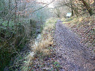
Langford Heathfield comprises a variety of semi-natural habitats which includes neutral marshy grassland and ancient woodland. An outstanding assemblage of 26 different species of resident breeding butterflies have been recorded. Of these marsh fritillary (Euphydryas aurina), high brown fritillary (Argynnis cydippe), wood white (Leptidea sinapis) and brown hairstreak (Thecla betulae) all have a local distribution in Somerset. Other invertebrates of interest include the very local beetles: Mordellistena abdominalis and Ischnomera caerulea , and hornet ( Vespa crabro ).

Grasslands are areas where the vegetation is dominated by grasses (Poaceae); however, sedge (Cyperaceae) and rush (Juncaceae) families can also be found along with variable proportions of legumes, like clover, and other herbs. Grasslands occur naturally on all continents except Antarctica. Grasslands are found in most ecoregions of the Earth. For example, there are five terrestrial ecoregion classifications (subdivisions) of the temperate grasslands, savannas, and shrublands biome (ecosystem), which is one of eight terrestrial ecozones of the Earth's surface.

In the United Kingdom, an ancient woodland is a woodland that has existed continuously since 1600 or before in England, Wales and Northern Ireland. Before those dates, planting of new woodland was uncommon, so a wood present in 1600 was likely to have developed naturally.

The marsh fritillary is a butterfly of the family Nymphalidae. Commonly distributed in the Palearctic region, the marsh fritillary got its common name due to its habitat: marshy, damp wetlands and grasslands. The prolonged larval stage lasts for approximately seven to eight months and includes a period of hibernation over the winter. The larvae are dependent on the host food plant Succisa pratensis not only for feeding but also for hibernation, because silken webs are formed on the host plant as the gregarious larvae enter hibernation. Because female butterflies lay eggs in batches on the host plant, females are selective about the location of oviposition. The cost of laying the batches of eggs at an unfavorable location is high and extensive.
Four species of reptile are present: adder ( Vipera berus ), grass snake (Natrix natrix), slow-worm (Anguis fragilis) and common lizard (Lacerta vivipara). Palmate newts (Triturus helveticus) occur in the ponds and common frogs (Rana temporaria) are frequent. A wide range of birds have been recorded including nightingale (Luscinia megarhynchos) and grasshopper warbler (Locustella naevia). [1]
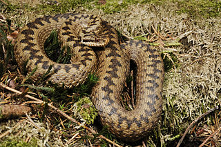
Vipera berus, the common European adder or common European viper, is a venomous snake that is extremely widespread and can be found throughout most of Western Europe and as far as East Asia. Known by a host of common names including common adder and common viper, adders have been the subject of much folklore in Britain and other European countries. They are not regarded as especially dangerous; the snake is not aggressive and usually bites only when really provoked, stepped on, or picked up. Bites can be very painful, but are seldom fatal. The specific name, berus, is New Latin and was at one time used to refer to a snake, possibly the grass snake, Natrix natrix.

The grass snake, sometimes called the ringed snake or water snake, is a Eurasian non-venomous snake. It is often found near water and feeds almost exclusively on amphibians. The barred grass snake, Natrix helvetica, was split off as a separate species in 2017.
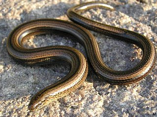
Anguis fragilis is a reptile native to Eurasia. It is also called a deaf adder, a slowworm, a blindworm or, regionally, a long-cripple, to distinguish it from the Peloponnese slowworm. These legless lizards are also sometimes called common slowworms. The 'blind' in 'blindworm' refers to the lizard's small eyes, similar to a blindsnake.