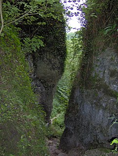
Ebbor Gorge is a limestone gorge in Somerset, England, designated and notified in 1952 as a 63.5-hectare (157-acre) biological Site of Special Scientific Interest in the Mendip Hills. It was donated to the National Trust in 1967 and is now managed by Natural England as a national nature reserve.

Seven Barrows is a Bronze Age bowl barrow cemetery, 4-hectare (9.9-acre) of which are designated a biological Site of Special Scientific Interest, at Upper Lambourn in the civil parish of Lambourn in the English county of Berkshire. It is managed by the Berkshire, Buckinghamshire and Oxfordshire Wildlife Trust and it is a Scheduled Monument.

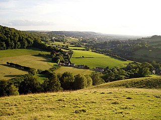
Crook Peak to Shute Shelve Hill is a 332.2 hectare (820.9 acre) geological and biological Site of Special Scientific Interest near the western end of the Mendip Hills, Somerset. The line of hills runs for approximately 5 kilometres (3.1 mi) from west to east and includes: Crook Peak, Compton Hill, Wavering Down, Cross Plain and Shute Shelve Hill. Most of the site is owned by the National Trust, which bought 725 acres (293 ha) in 1985, and much of it has been designated as common land. It was notified as an SSSI by Natural England in 1952.
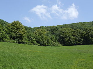
Cheddar Wood is an 86.9-hectare (215-acre) biological Site of Special Scientific Interest at Cheddar in the Mendip Hills, Somerset, England, notified in 1967.

Rodney Stoke is a 69.6 hectare biological Site of Special Scientific Interest, just north of the village of Rodney Stoke in the Mendip Hills, Somerset, notified in 1957.
The Perch is a 72.1 hectare biological Site of Special Scientific Interest close to Cheddar Gorge in the Mendip Hills, Somerset, England. It received SSSI notification in 1990.

The Cheddar Complex is a 441.3 hectare biological Site of Special Scientific Interest near Cheddar around the Cheddar Gorge and north east to Charterhouse in the Mendip Hills, Somerset, England, notified in 1952.

Hardington Moor is an 8.7 hectare biological Site of Special Scientific Interest between Hardington Mandeville and West Coker in Somerset, notified in 1994.

Babcary Meadows is a 13.6 hectares biological Site of Special Scientific Interest north of Babcary in Somerset, notified in 1988.
East Polden Grasslands is a 124 hectare biological Site of Special Scientific Interest on the Polden Hills in Somerset, notified in 1999.

Great Breach and Copley Woods is a 64.8 hectare biological Site of Special Scientific Interest 1 km south of Compton Dundon and 5 km south-east of Street in Somerset, England, notified in 1972.

Thurlbear Wood and Quarrylands is a 26.7 hectare biological Site of Special Scientific Interest south of Stoke St Mary in Somerset, notified in 1963.

Walton and Ivythorn Hills is a 34.9 hectares biological Site of Special Scientific Interest near Street at the south-eastern end of the Polden Hills in the English county of Somerset. Walton Hill is south of the village of Walton, and Ivythorn Hill is south of Street. Notified in 1953, the site is now owned and managed by the National Trust who acquired the freehold in 1988.

Hackhurst and White Downs is a 185.1-hectare (457-acre) biological Site of Special Scientific Interest west of Dorking in Surrey. White Downs is a Nature Conservation Review site, Grade 2, and part of it is in the 200-hectare (490-acre) White Downs nature reserve, which is owned by the Wotton Estate and managed by the Surrey Wildlife Trust (SWT). Hackhurst Downs is a 29.9-hectare (74-acre) Local Nature Reserve, which part of the 40-hectare (99-acre) Hackhurst Downs nature reserve, which is owned by Surrey County Council and also managed by the SWT.

Brassey is a 2.1-hectare (5.2-acre) biological Site of Special Scientific Interest in Gloucestershire, notified in 1954 and renotified in 1983. It is situated on the north side of the Windrush Valley, midway between Naunton and Upper Slaughter. The reserve comprises sloping, unimproved limestone pasture. There is a fast-flowing stream. This site is one of the few freshwater marshes in Gloucestershire. The stream joins the River Windrush.
Swift's Hill is a 9.15-hectare (22.6-acre) biological and geological Site of Special Scientific Interest in Gloucestershire, notified in 1966 and renotified in 1984.

Bull Cross, The Frith and Juniper Hill is a 42.33-hectare (104.6-acre) biological and geological Site of Special Scientific Interest in Gloucestershire, notified in 1954. The site is listed in the ‘Stroud District’ Local Plan, adopted November 2005, Appendix 6 as an SSSI and Regionally Important Geological Site (RIGS).

Leckhampton Hill and Charlton Kings Common is a 63.8-hectare (158-acre) biological and geological Site of Special Scientific Interest in Gloucestershire, notified in 1954. There are five units of assessment.

Rough Bank, Miserden is a 9.2-hectare (23-acre) biological Site of Special Scientific Interest in Gloucestershire, notified in 1986. It was purchased by the wildlife charity Butterfly Conservation in 2012.

Bacombe and Coombe Hills is a 76.4 hectare biological Site of Special Scientific Interest in Upper Bacombe in Buckinghamshire. Bacombe Hill was formerly owned by Buckinghamshire County Council, which transferred it to Berkshire, Buckinghamshire and Oxfordshire Wildlife Trust in 2014. Coombe Hill is owned by the National Trust.

