Burrington Combe

Last updated

Burrington Combe
Site of Special Scientific Interest
Top of Burrington Combe - geograph.org.uk - 74494.jpg
Somerset UK location map.svg
Red pog.svg
Location within Somerset
Location Avon
Grid reference ST478583
Coordinates 51°19′17″N2°45′02″W / 51.32140°N 2.75047°W / 51.32140; -2.75047
InterestBiological and Geological
Area139.1 ha (344 acres)
Notification 1952 (1952)
Natural England website

Burrington Combe is a Carboniferous Limestone gorge near the village of Burrington, on the north side of the Mendip Hills Area of Outstanding Natural Beauty, in North Somerset, England.

Contents

"Combe" or "coombe" is a word of Celtic origin found in several forms on all of the British Isles, denoting a steep-sided valley or hollow. Burrington Combe is a gorge through the limestone hills although there is now no river running through it. Various cave entrances are exposed which have been occupied by humans for over 10,000 years, with a hillfort being built beside the combe in the Iron Age. The geology has led to a diversity of plant life.

According to legend Augustus Montague Toplady was inspired to write the hymn Rock of Ages while sheltering under a rock in the combe, although recent scholars have disputed this claim.

Geology

Water draining from Black Down has exposed rocks from the Devonian sandstones of the Portishead Formation which show through the limestone, Carboniferous mudstones of the Avon Group, limestones of the Black Rock Limestone Subgroup and oolitic limestones of the Burrington Oolite Subgroup; however the exact mechanism by which the gorge was formed is unknown. [1] The northern and lower end of the combe, which was once the bed of the Congresbury Yeo, cuts through overlying Clifton Down Limestone. Triassic dolomitic conglomerate can also locally be seen along the combe. [2]

Caves

Archaeological discoveries of early cemeteries demonstrate human occupation of the combe and its caves from the Bronze Age with some evidence of occupation during the Upper Palaeolithic period. [3] The combe contains the entrances to many of the caves of the Mendip Hills, including Aveline's Hole, Sidcot Swallet and Goatchurch Cavern. A through trip has been dug from Rod's Pot to Bath Swallet, which are both on the hills above the majority of Burrington caves. Further afield and equally accessible is Read's Cavern.

Goatchurch Cavern is 1,500 m (4,900 ft) long and has a surveyed depth of 61.5 m (202 ft). It was first recorded in 1736, [4] and explored by lead miners in the 19th century. [5] Around 1901, the owner unsuccessfully tried to turn it into a show cave. [6] Notes of exploration in the 1920s record finds from the Pleistocene period including bones of mammoth, bear, hyena and cave lion. [7] During November 2003 inscribed marks were noticed in Goatchurch Cavern while cleaning away graffiti. Three finely cut marks were uncovered, resembling the letter W with a patina darker than in nearby graffiti dated 1704. These have been identified as ritual protection marks (also known as witch marks or apotropaic marks), possibly dating from the period 1550 to 1750. [8]

Aveline's Hole Avelineshole.jpg
Aveline's Hole

A swallet, also known as a sinkhole, sink, shakehole, swallow hole or doline, is a natural depression or hole in the surface topography caused by the removal of soil or bedrock, often both, by water flowing beneath the water-table at considerable depth. Sidcot Swallet is named after the Sidcot School Speleological Society who explored it in 1925. [9]

The earliest scientifically dated cemetery in Great Britain was found at Aveline's Hole. The human bone fragments it contained, from about 21 different individuals, are thought to be between roughly 10,200 and 10,400 years old. [10] A series of inscribed crosses found on the wall of the Aveline's Hole cave are believed to date from the early Mesolithic period just after the Ice age. [11]

Hillfort

Above the combe on its eastern side is the site of an Iron Age univallate hill fort known as Burrington Camp. [12] It is around 100 metres (330 ft) by 80 metres (260 ft) and includes Romano-British elements. [3]

Special Scientific Interest

The combe and surrounding gorse Burrington Combe - geograph.org.uk - 7895.jpg
The combe and surrounding gorse

In recognition of its biological and geological interest, an area of 139.1 hectares (344 acres) within and around the combe was notified as a Site of Special Scientific Interest in 1952. [13]

The calcareous grasslands support a diverse flora which includes salad burnet ( Sanguisorba minor ), knapweed ( Centaurea scabiosa and Centaurea nigra ), rock-rose ( Helianthemum nummularium ) and wild thyme ( Thymus praecox ). On the higher, more acidic, slopes goldenrod ( Solidago virgaurea ), wood sage ( Teucrium scorodonia ) and common bent ( Agrostis capillaris ) can be found. There are also scrub plants including hawthorn ( Crataegus monogyna ), mountain ash ( Sorbus aucuparia ), gorse ( Ulex europaeus ) and elder ( Sambucus nigra ). Several of the caves support bat populations. [13]

Geologically it is recognised as a fluvial karst feature which partly intersects a buried and filled gorge of Triassic age. [13]

Rock of Ages

Rock of Ages, Burrington Combe Rock of ages.jpg
Rock of Ages, Burrington Combe

There is a legend that Augustus Montague Toplady (1740–78), who was the curate at Blagdon, [14] was inspired to write the hymn Rock of Ages while sheltering under a rock in the combe during a thunderstorm in the late 18th century. [15] The rock was subsequently named after the hymn. It is now generally accepted that the attribution of this location to the writing of Rock of Ages only arose well after Toplady's death (the 1850s is suggested by Percy Dearmer in Songs of Praise Discussed, 1933) and has no proven factual basis.

The then Vicar at Westbury-on-Trym H. J. Wilkins published a 16-page booklet in 1938 titled "An Enquiry concerning Toplady and his Hymn "Rock of Ages" and its connection with Burrington Combe, Somerset" that found that in relation to the hymn "All available evidence goes to show that it was published in 1776, soon after it was written." Toplady had left the neighbourhood of Burrington Combe in 1764. [16]

In George Lawton's 1983 publication Within the Rock of Ages the author finds the claim that Rock of Ages was written at Burrington Combe to be only a legend, although he does state that "It is extremely doubtful whether at this distance of time, the legend that it was written in a cleft there can be proved or disproved." [17] In George Ella's 2000 study A Debtor to Mercy Alone any links between the hymn and Burrington Combe are again said to be no more than legendary, with readers being referred to Lawton's 1983 study. [18]

C. H. Sisson wrote a poem entitled Burrington Combe, collected in Exactions (Manchester: Carcanet 1980). The local area, including Black Down and Ellick Farm, features prominently in his poetry.

Related Research Articles

<span class="mw-page-title-main">Mendip Hills</span> Range of limestone hills to the south of Bristol and Bath in Somerset, England

The Mendip Hills is a range of limestone hills to the south of Bristol and Bath in Somerset, England. Running from Weston-super-Mare and the Bristol Channel in the west to the Frome valley in the east, the hills overlook the Somerset Levels to the south and the Chew Valley and other tributaries of the Avon to the north. The highest point, at 325 metres above sea level, is Beacon Batch which is the summit area atop Black Down. The hills gave their name to the former local government district of Mendip, which administered most of the local area until April 2023. The higher, western part of the hills, covering 198 km2 (76 sq mi) has been designated an Area of Outstanding Natural Beauty (AONB), which gives it a level of protection comparable to a national park.

<span class="mw-page-title-main">Swildon's Hole</span> Cave in Somerset, England

Swildon's Hole is an extensive cave in Priddy, Somerset. At 9,144 metres (30,000 ft) in length, it is the longest cave on the Mendip Hills. It has been found to be connected to Priddy Green Sink and forms part of the Priddy Caves Site of Special Scientific Interest (SSSI).

<span class="mw-page-title-main">River Axe (Bristol Channel)</span> River in Somerset, England

The River Axe is a river in South West England. The river is formed by water entering swallets in the limestone and rises from the ground at Wookey Hole Caves in the Mendip Hills in Somerset, and runs through a V-shaped valley. The geology of the area is limestone and the water reaches Wookey Hole in a series of underground channels that have eroded through the soluble limestone. The river mouth is in Weston Bay on the Bristol Channel.

Lamb Leer is a 14.59 hectare geological Site of Special Scientific Interest between East Harptree and Priddy in the Mendip Hills, Somerset, notified in 1983. The cavern is a fragment of a very ancient major cave system which now contains one of the largest chambers in the Mendip Hills.

<span class="mw-page-title-main">Cheddar Complex</span> Site of Special Scientific Interest in Somerset, England

The Cheddar Complex is a 441.3-hectare (1,090-acre) biological Site of Special Scientific Interest near Cheddar around the Cheddar Gorge and north east to Charterhouse in the Mendip Hills, Somerset, England, notified in 1952.

Thrupe Lane Swallet is a 0.5 hectares geological Site of Special Scientific Interest in Somerset, notified in 1992. It is also a Geological Conservation Review site.

<span class="mw-page-title-main">Caves of the Mendip Hills</span>

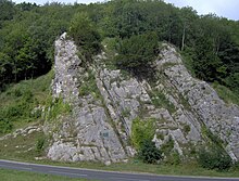
The caves of the Mendip Hills are formed by the particular geology of the Mendip Hills: large areas of limestone worn away by water makes it a national centre for caving. The hills conceal the largest underground river system in Britain.

<span class="mw-page-title-main">Aveline's Hole</span> Cave and archaeological site in the United Kingdom

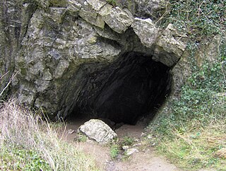
Aveline's Hole is a cave at Burrington Combe in the limestone of the Mendip Hills, in Somerset, England.

<span class="mw-page-title-main">Eastwater Cavern</span> Limestone cave in Somerset, England

Eastwater Cavern is a cave near Priddy in the limestone of the Mendip Hills, in Somerset, England. It is also known as Eastwater Swallet. It was first excavated in April 1902 by a team led by Herbert E. Balch composed of paid labourers and volunteers from the Wells Natural History Society. Progress was initially slow, but by February 1903 Balch and Willcox had discovered substantial passage, following the streamway down to the bottom of the cave. Dolphin Pot was dug in 1940 by the Wessex Cave Club, with Primrose Pot following in 1950. West End series was the most recent significant discovery, in 1983.

<span class="mw-page-title-main">GB Cave</span> Limestone cave in Somerset, England

GB Cave is a cave between Charterhouse and Shipham in the limestone of the Mendip Hills, in Somerset, England.

<span class="mw-page-title-main">Goatchurch Cavern</span> Limestone cave in Somerset, England

Goatchurch Cavern is a cave on the edge of Burrington Combe in the limestone of the Mendip Hills, in Somerset, England.

<span class="mw-page-title-main">St Cuthbert's Swallet</span> Cave in the Mendip Hills, Somerset, England

St Cuthbert's Swallet is the second longest, and most complex, cave on the Mendip Hills, in Somerset, England. It forms a major part of the Priddy Caves system and water entering this swallet re-emerges at Wookey Hole. St Cuthbert's Swallet is part of, and lies underneath, the Priddy Pools Site of Special Scientific Interest.

<span class="mw-page-title-main">Stoke Lane Slocker</span> Limestone cave in Somerset, England

Stoke Lane Slocker is a cave near Stoke St Michael, in the Carboniferous Limestone of the Mendip Hills, in the English county of Somerset.

<span class="mw-page-title-main">Upper Flood Swallet</span> Limestone cave in Somerset, England

Upper Flood Swallet which was originally known as Blackmoor Flood Swallet, is an exceptionally well-decorated cave near Charterhouse, in the carboniferous limestone of the Mendip Hills, in Somerset, England. The cave is part of the Cheddar Complex SSSI.

Sidcot Swallet is a cave near Burrington Combe, in the Carboniferous Limestone of the Mendip Hills, in Somerset, England.

<span class="mw-page-title-main">Rod's Pot</span> Cave in Somerset, England

Rod's Pot is a limestone cave above Burrington Combe in the Mendip Hills, in Somerset, England.

Attborough Swallet is a cave in Chewton Mendip in Somerset, England.

<span class="mw-page-title-main">Pierre's Pot</span> Cave in Somerset, England


Pierre's Pot is a karst cave in Burrington Combe on the Mendip Hills in Somerset, England.

Hunter's Hole is a cave in the Mendip Hills in Somerset, England. It is behind a pub, known as the Hunters Lodge Inn just outside Priddy where visitors can park. It is accessed via a permanent ladder, about 100m behind the pub in a small dip between some trees.

William Talbot Aveline (1822–1903) was a British geologist and archaeologist.

References

  1. Haslett, Simon K. (2010). Somerset Landscapes: Geology and landforms. Usk: Blackbarn Books. pp. 105–108. ISBN   978-1-4564-1631-7.
  2. "Burrington Combe". British Geological Survey. Retrieved 29 January 2011.
  3. 1 2 Ellis, Peter. "Mendip Hills An Archaeological Survey of the Area of Outstanding Natural Beauty" (PDF). Somerset County Council. p. 26. Retrieved 29 January 2011.
  4. Witcombe, Richard (2009). Who was Aveline anyway?: Mendip's Cave Names Explained (2nd ed.). Priddy: Wessex Cave Club. pp. 80–81. ISBN   978-0-9500433-6-4.
  5. Johnson, Peter (1967). The History of Mendip Caving. Newton Abbott: David & Charles. ASIN   B0000CNIE0.
  6. Barrington, Nicholas; William Stanton (1977). Mendip: The complete caves. Cheddar: Cheddar Valley Press. ISBN   978-0-9501459-1-4.
  7. Irwin, David; Anthony Knibbs (1977). Mendip Underground: A Cavers Guide. Somerset: Mendip Publishing. ISBN   0-9536103-0-6.
  8. "Goatchurch Cavern marks". Apotropaios. Archived from the original on 31 December 2006. Retrieved 27 January 2007.
  9. Witcombe, Richard (2009). Who was Aveline anyway?: Mendip's Cave Names Explained (2nd ed.). Priddy: Wessex Cave Club. p. 161. ISBN   978-0-9500433-6-4.
  10. "Earliest British cemetery dated". BBC. 23 September 2003. Retrieved 5 January 2010.
  11. "Aveline's Hole Discovery". University of Bristol Spelaeological Society. Retrieved 5 January 2010.
  12. "Burrington Camp". Fortified Britain. Retrieved 29 January 2011.
  13. 1 2 3 "Burrington Combe" (PDF). SSSI Citation sheet. English Nature. Retrieved 21 October 2008.
  14. "Sheltering in the Rock". Banner of Truth. Archived from the original on 22 August 2006. Retrieved 19 January 2011.
  15. "Rock of Ages". The Ensign Message. Retrieved 15 November 2016.
  16. "An Enquiry concerning Toplady and his Hymn "Rock of Ages" and its connection with Burrington Combe, Somerset" (PDF). Toplady.org.uk. Retrieved 29 January 2011.
  17. Lawton, George (1982). Within the Rock of Ages. James Clarke & Co Ltd. ISBN   978-0-227-67836-7.
  18. Ella, George (2000). Augustus Montague Toplady: A Debtor to Mercy Alone. Go Publications. ISBN   978-0-9527074-5-5.