
The Kennet and Avon Canal is a waterway in southern England with an overall length of 87 miles (140 km), made up of two lengths of navigable river linked by a canal. The name is used to refer to the entire length of the navigation rather than solely to the central canal section. From Bristol to Bath the waterway follows the natural course of the River Avon before the canal links it to the River Kennet at Newbury, and from there to Reading on the River Thames. In all, the waterway incorporates 105 locks.

The Avon Gorge is a 1.5-mile (2.5-kilometre) long gorge on the River Avon in Bristol, England. The gorge runs south to north through a limestone ridge 1.5 miles (2.4 km) west of Bristol city centre, and about 3 miles (5 km) from the mouth of the river at Avonmouth. The gorge forms the boundary between the unitary authorities of North Somerset and Bristol, with the boundary running along the south bank. As Bristol was an important port, the gorge formed a defensive gateway to the city.

Keynsham Humpy Tumps is a floristically rich acidic grassland site situated between the town of Keynsham, and the River Avon, southeast of Bristol, England.

Wellow is a village and civil parish in Somerset, England, about 5 miles (8.0 km) south of Bath. The parish, which includes the hamlets of Twinhoe, White Ox Mead, Baggridge and part of Midford has a population of 529. The village itself falls within the southernmost boundary of the Cotswolds Area of Outstanding Natural Beauty and is recognised as having special architectural and historic interest, which led to it being designated as a Conservation Area in 1983.

Hunstrete Lake is a mature lake of 5 acres (20,000 m2). Two new lakes of 3.5 acres (14,000 m2) were constructed alongside in the 1990s. They are situated just to the south of the village of Hunstrete, Somerset; south of Bristol, and 7 miles (11 km) west of Bath. It is surrounded by a belt of trees, and at the north-west end this merges into Lord's Wood, Pensford.

Leigh Woods is a 2-square-kilometre (0.77 sq mi) area of woodland on the south-west side of the Avon Gorge, close to the Clifton Suspension Bridge, within North Somerset opposite the English city of Bristol and north of the Ashton Court estate, of which it formed a part. Stokeleigh Camp, a hillfort thought to have been occupied from the third century BC to the first century AD and possibly also in the Middle Ages, lies within the reserve on the edge of the Nightingale Valley. On the bank of the Avon, within the reserve, are quarries for limestone and celestine which were worked in the 18th and 19th centuries are now derelict.

The North Somerset Levels is a coastal plain, an expanse of low-lying flat ground, which occupies an area between Weston-super-Mare and Bristol in North Somerset, England. The River Banwell, River Kenn, River Yeo and Land Yeo are the three principal rivers draining the area.

Folly Farm is a traditionally managed working farm and nature reserve run by the Avon Wildlife Trust. It is located between Stowey, Clutton and Stanton Wick in the civil parish of Stowey in the English county of Somerset.

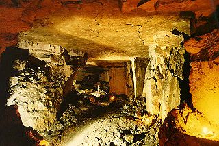
Harptree Combe is a 13.63-hectare (33.68-acre) Site of Special Scientific Interest (SSSI) near East Harptree notified in 1954. "Combe" or "coombe" is a West Country word meaning a steep-sided valley. It is also the site of a 19th-century aqueduct and is overlooked by the site of a castle dating from around 1100.
Wade Browne's Folly is a folly tower sitting within a 39.9 hectare biological and geological Site of Special Scientific Interest (SSSI) near the village of Bathford in Somerset, notified in 1974: the site itself is known as the Farleigh Down Stone Quarry, and is managed as a nature reserve by the Avon Wildlife Trust (AWT). The tower was built in 1848 and is a Grade II listed building.

Cleaves Wood is a 40.38 hectare biological Site of Special Scientific Interest (SSSI) near the village of Wellow in Bath and North East Somerset, notified in 1988.
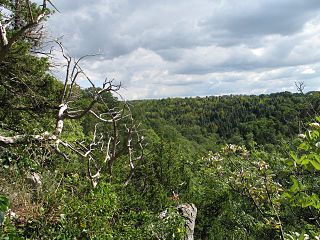
Goblin Combe is a dry valley in North Somerset which stretches for approximately 3½ km from Redhill, near Bristol International Airport on the A38, through to Cleeve on the A370. The combe is located at, and is a 52 hectares biological Site of Special Scientific Interest (SSSI) originally notified in 1999, with 9 hectares being managed as a nature reserve by the Avon Wildlife Trust. The Combe runs along the southern edge of a large woodland. "Combe" is the same as the Welsh word "cwm" which means valley.
Yanal Bog is a 1.6 hectare biological Site of Special Scientific Interest on the southern edge of the North Somerset Levels, just north of the village of Sandford, North Somerset. It was notified as an SSSI in 1988.

St. Catherine's Valley is a 156.1 hectare biological Site of Special Scientific Interest southwest of the village of Marshfield, South Gloucestershire, notified in 1997.
Weston Big Wood is a 37.48 hectare woodland west of the town of Portishead, North Somerset, England. It is a nature reserve and biological Site of Special Scientific Interest, notified in 1971. The wood takes its name from the nearby village of Weston-in-Gordano.

Long Dole Wood and Meadows SSSI is a 9.8 hectares biological Site of Special Scientific Interest (SSSI) between the villages of Farrington Gurney and Hinton Blewitt in Bath and North East Somerset, notified in 1987.

Purn Hill is a 6.1 hectare biological Site of Special Scientific Interest near the village of Bleadon, Somerset, notified in 1990. The site is a small promontory of Carboniferous Limestone projecting southward from the main Mendip ridge.
Cleeve is a village and civil parish in the ceremonial county of Somerset, England. It is situated within the unitary authority of North Somerset, 9 miles (14 km) south west of Bristol and has a population of 902.

Trinia glauca (Honewort) is a low-growing umbellifer found in rocky areas.
Ron Ward's Meadow With Tadley Pastures is a site of Site of Special Scientific Interest (SSSI). It is based on the edge of Tadley in Hampshire, England. It is managed by the Hampshire and Isle of Wight Wildlife Trust.

