This page is based on this
Wikipedia article Text is available under the
CC BY-SA 4.0 license; additional terms may apply.
Images, videos and audio are available under their respective licenses.

Crofton Park is a mainly residential suburb and electoral ward in the London Borough of Lewisham.
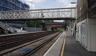
Brockley railway station serves the south-east London district of Brockley and is on the main railway line between London Bridge and Brighton. It is 3 miles 56 chains (5.95 km) down the line from London Bridge.

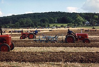
Lewisham parks and open spaces are part of the "green lung" of London and include a diverse range of sites, from small urban parks and gardens to one of the most historic natural landscapes in Greater London at Blackheath. While overall control rests with London Borough of Lewisham, management of borough-owned parks and their facilities is contracted out to Glendale Grounds Management.

Brockley Whins Metro station is on the Tyne and Wear Metro's Green Line. It serves the Brockley Whins area of South Shields as well as northern Boldon Colliery, both in South Tyneside.

Ladywell is a district of South East London, England, and a ward in the London Borough of Lewisham between Brockley, Crofton Park and Lewisham. It has been named by Living Monthly magazine as one of the top places to live in London. It has ample green space including Ladywell Fields and Hilly Fields which borders Brockley. Ladywell Village, the main shopping area along Ladywell Road, was given a face lift in 2013 with £800,000 of Transport for London funding. The pavements were widened, short stay bays created to help local businesses and shoppers, and trees were added. Ladywell Village has a range of retail outlets including a number of cafes, a patisserie and a delicatessen.

Brockley Hill was a proposed London Underground station in the Brockley Hill area of north London. The planned location is in what is now Edgware Way Grassland close to Edgwarebury Park on the north side of the junction of Edgware Way / Watford Bypass (A41), and Spur Road (A410).

Elstree South was a proposed London Underground station in Elstree, Hertfordshire. It was designed by Charles Holden. The planned location of the station was adjacent to the A5183, north of the junction with the A41 and where junction 4 of the M1 motorway was subsequently built.

Brockley (not to be confused with Brockley Green, 8 miles southwest in Hundon parish) is a village and civil parish in the St Edmundsbury borough of Suffolk, England. Brockley parish includes the hamlets of Pound Green and Gulling Green. According to the 2001 Census parish population was 281, and increased to 312 at the 2011 Census.

Brockley Combe is a wooded combe near the village of Brockley in North Somerset, England. The combe cuts into the western edge of the Lulsgate Plateau, the Carboniferous limestone hills which form a northern outlier of the Mendips, south west of Bristol.
The Lewisham line
is a short section of railway line in south east London which links the Catford Loop line to the South Eastern main line. It provides a link for freight trains travelling from north London to the south east, as well as a route for passenger trains from London Victoria station to destinations in Kent.

The A1300 is the main 'cross town' route in South Shields, Tyne and Wear. The road runs from Simonside to Marsden via Harton Nook.

Brockley and Ladywell Cemeteries were opened within one month of each other in 1858 and are sited on adjacent plots of previously open land. The two component parts are characteristic examples of the first wave of Victorian public cemeteries and are now part of the Brockley Conservation Area.

Brockley Lane is a closed railway station in Brockley, south London. It was opened in June 1872 by the London, Chatham and Dover Railway on its Greenwich Park Branch Line. It closed to passengers in January 1917 with the branch, but remained open as a goods station until May 1970.

Brockley Hill, Stanmore, is an area of high ground on the outskirts of North London, England. The hill, which rises to 136 metres (446 ft) above sea level, is traversed by the A5 road. It follows the course of the Roman road known as Watling Street. The hill is also associated with the Roman archaeological site called Sulloniacis. The Royal National Orthopaedic Hospital is based at Brockley Hill.
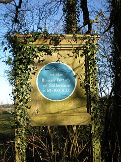
Sulloniacis or Sulloniacae is the name of a place in Roman Britain which is known only from an entry in the Antonine Itinerary, a listing of routes and facilities for the cursus publicus, the official courier service of the Roman Empire. Iter (Itinerary) II of the British section runs between Richborough and Chester (Deva), and this shows Sulloniacis on the road now known as Watling Street, nine Roman miles from St Albans (Verulamium) and 12 from London. Sulloniacis is usually identified with Roman remains found at Brockley Hill near Edgware in the London Borough of Barnet.
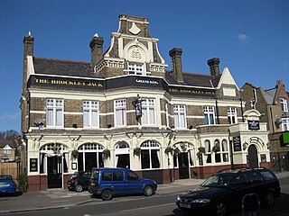
The Brockley Jack Theatre is an Off West End theatre in the Crofton Park area of Lewisham, south London. It shares a building with the Brockley Jack pub.

New Cross Gate Cutting or Brockley Nature Reserve is a 4.2 hectare nature reserve in Brockley in the London Borough of Lewisham. It is a Site of Metropolitan Importance for Nature Conservation managed by the London Wildlife Trust. This designated green space runs alongside the East London Line between Brockley and New Cross Gate, on the forest site that once lay on the Kent and Surrey border known as Hatcham Wood. The entrance is on Vesta Road situated between Barriedale in Brockley and Sandbourne Road, Telegraph Hill.