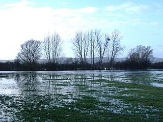
Walmore Common is a 57.78-hectare (142.8-acre) nature reserve on the flood-plain of the River Severn, west of the city of Gloucester in England and north of the village of Chaxhill. It was notified as a biological Site of Special Scientific Interest in 1966. The site is listed in the 'Forest of Dean Local Plan Review' as a Key Wildlife Site (KWS).

Long Dole Wood and Meadows SSSI is a 9.8 hectares biological Site of Special Scientific Interest (SSSI) between the villages of Farrington Gurney and Hinton Blewitt in Bath and North East Somerset, notified in 1987.

Monkswood Valley is a 30.7-hectare biological Site of Special Scientific Interest (SSSI) near the village of Cold Ashton, South Gloucestershire, notified in 1990.
Whitton Bridge Pasture is a Site of Special Scientific Interest (SSSI) in the unitary authority of Stockton-on-Tees, England. At 3.18 hectares (7.9 acres) it lies to the south of Whitton village and north west of Stockton-on-Tees. SSSIs are chosen by Natural England, and Whitton Bridge Pasture was designated in 2004 because of its biological interest. It is one of 18 SSSIs in the Cleveland area of search.

Acaster South Ings is a Site of Special Scientific Interest, or SSSI, near York, England. It consists of two alluvial flood-meadows, and was designated in 1988 because it supports diverse fauna and flora, some of which is rare in the Vale of York area. One of the rarities is the tansy beetle, which feeds on the leaves of the tansy plant.

Pittington Hill is a Site of Special Scientific Interest in County Durham, England. It lies adjacent to the village of Pittington, some 6 km north-east of Durham city. A disused quarry occupies part of the site.
Raisby Hill Grassland is a Site of Special Scientific Interest in east County Durham, England. It lies just over 1 km east of the village of Coxhoe.
Town Kelloe Bank is a Site of Special Scientific Interest in County Durham, England. It is situated to the south of The Bottoms SSSI and just north of the village of Town Kelloe.

Edge Common is a 20.47-hectare (50.6-acre) biological Site of Special Scientific Interest in Gloucestershire, notified in 1974.

Minchinhampton Common is a 182.7-hectare (451-acre) biological and geological Site of Special Scientific Interest in Gloucestershire, notified in 1972.

Range Farm Fields is a 12.8-hectare (32-acre) biological Site of Special Scientific Interest in Gloucestershire, near to Gloucester City, notified in 1996.

Rodborough Common is a 116.0-hectare (287-acre) biological and geological Site of Special Scientific Interest in Gloucestershire, notified in 1954. The site is listed in the ‘Stroud District’ Local Plan, adopted November 2005, Appendix 6 as an SSSI and a Regionally Important Geological Site (RIGS). The Common is also a Special Area of Conservation (SAC) under the EU Habitats Directive

Quarry Moor is a Site of Special Scientific Interest, or SSSI, at the south edge of Ripon, North Yorkshire, England, and adjacent to the A61 road. It contains an outcrop of Magnesian Limestone, exposed by former quarrying. 255 million years ago this limestone was the peripheral sediment of a tropical sea. The land was donated in 1945 to the people of Ripon by the town's mayor, Alderman Thomas Fowler Spence, a varnish manufacturer. The land was notified as an SSSI in 1986 because its calcareous grassland supported a large diversity of plant species. The site features a Schedule 8 protected plant, thistle broomrape. The land is protected as a nature reserve, and it is also managed as a recreational area. Therefore, its calcareous grass area is fenced off for protection and study, but it also contains a car park, information signs, a children's play area, accessible paths, benches, and dog waste bins.
Farnham Mires is a Site of Special Scientific Interest, or SSSI, to the east of the village of Farnham, North Yorkshire, England. It consists of a spring-fed marshy fen or mire with reeds and sedge, and drier calcareous grassland containing a diverse range of flora. It has a history of poaching and fox hunting, but since the late 19th century, the attention of botanists has been drawn to its large variety of flowering plants. It has received some consideration on this account since 1944, and from 1954 it was designated SSSI status. This site has no facilities, and is not open to the public.

Bishop Monkton Ings is a Site of Special Scientific Interest, or SSSI, situated east of Bishop Monkton village in North Yorkshire, England. It consists mostly of marshy, calcareous grassland, with some broadleaved woodland, and some fen alongside the two watercourses which run through the site. This varied wetland forms a habitat for a variety of plants, including the semi-parasitic marsh lousewort (Pedicularis palustris).

Mar Field Fen is a Site of Special Scientific Interest, or SSSI, north of Masham, North Yorkshire, England, in a rural area known as Marfield. It is situated on land containing woodland carr, fen, spring-fed marshy grassland and drier calcareous grassland, between the River Ure to the east and Marfield Wetland nature reserve to the west. As "one of the best examples of fen habitat in the Vale of York," it is a protected habitat for a variety of plants, including the common butterwort, a carnivorous plant. There is no public access to this site.

Ripon Parks is a Site of Special Scientific Interest, or SSSI, situated north of Ripon, to the west of the River Ure and to the east of the village of North Stainley, in North Yorkshire, England. It was once part of the land held since the Middle Ages as a deer park by the archbishops of York and the canons of Ripon. The site was designated as an SSSI in 1983, because its varied habitats are valued for their breeding birds, amphibians and varied flora. The woods here are "of note" for the parasitic flowers of common toothwort and yellow star-of-Bethlehem. A small part of the site is accessible via public footpaths; there are no public facilities or dedicated car parks. The site incorporates the High Batts Nature Reserve, which is privately run for training, recording and educational purposes, and accessible to members only, except for its annual open day. Ripon Parks is now owned by the Ministry of Defence, and parts of the site are used as military training areas.
Kirk Deighton SSSI is a Site of Special Scientific Interest (SSSI) in Alton's Field, Kirk Deighton, North Yorkshire, England. This site has been recognised as having one of the largest known breeding populations of great crested newts in the United Kingdom. It is a Special Area of Conservation, and is listed for protection under a number of directives. This ordinary-looking grassland field, with a couple of ponds in it, is ideal habitat for the newts, which use the grassland for foraging, the ponds for breeding, and surrounding walls, hedges and woodpiles for hibernation. The site is not accessible to the public, and it is not permissible to survey the ponds without a licence.

Stonesfield Common, Bottoms and Banks is a 27.45-hectare (67.8-acre) biological Site of Special Scientific Interest (SSSI) south of Stonesfield in Oxfordshire.
