The Gloucestershire Wildlife Trust is the Gloucestershire local partner in a conservation network of 46 Wildlife Trusts. The Wildlife Trusts are local charities with the specific aim of protecting the United Kingdom's natural heritage. The Gloucestershire Wildlife Trust is managed by a board of trustees elected from its membership who provide overall direction for the development of the trust and there are advisory committees. The work of the trust is carried out through staff and volunteers.

Midger is a 65.7-hectare (162-acre) biological Site of Special Scientific Interest straddling the border of Gloucestershire and South Gloucestershire, notified in 1966 and renotified in 1984. Since the last revision in 1974, the size has been reduced to a 56-hectare (140-acre) site. It lies east of Hillesley, Gloucestershire and north of Hawkesbury Upton, South Gloucestershire. It is at the head of the Kilcott Valley.
Strawberry Banks is a 5.06-hectare (12.5-acre) biological Site of Special Scientific Interest in Gloucestershire, notified in 1993.

Brassey is a 2.1-hectare (5.2-acre) biological Site of Special Scientific Interest in Gloucestershire, notified in 1954 and renotified in 1983. It is situated on the north side of the Windrush Valley, midway between Naunton and Upper Slaughter. The reserve comprises sloping, unimproved limestone pasture. There is a fast-flowing stream. This site is one of the few freshwater marshes in Gloucestershire. The stream joins the River Windrush.

Daneway Banks is a 17-hectare (42-acre) biological Site of Special Scientific Interest in Gloucestershire, notified in 1954 and renotified in 1983. It lies half a mile west of Sapperton and is part of a group of wildlife sites in the Frome Valley that includes Siccaridge Wood and Sapperton Canal reserves. The site is in the Cotswold Area of Outstanding Natural Beauty.

Box Farm Meadows (Stuart Fawkes reserve) (grid reference ST865997) is a 8.3-hectare (21-acre) biological Site of Special Scientific Interest in Gloucestershire, notified in 1985. This was formerly known as Balls Green Pastures. The reserve is situated at the southern edge of Box village and one mile east of Nailsworth.

Wotton Hill is a hill on the edge of the Cotswold Hills in Gloucestershire, England, 0.5 miles (0.80 km) north of Wotton-under-Edge. The Cotswold Way passes over the hill.
Lower Wye Gorge is a 65-hectare (160-acre) biological and geological Site of Special Scientific Interest in Gloucestershire, notified in 1954 and renotified 1987. The site includes two Gloucestershire Wildlife Trust nature reserves being Ban-y-gor Wood and Lancaut. The Natural England citation states a revision for Lancaut inclusion.

Dymock Woods is a 53-hectare (130-acre) biological Site of Special Scientific Interest in Gloucestershire, notified in 1990. The site is listed in the 'Forest of Dean Local Plan Review' as a Key Wildlife Site (KWS).

Hobbs Quarry, Longhope is a 1-hectare (2.5-acre) geological and biological Site of Special Scientific Interest in Gloucestershire, England, notified in 1966. It is situated midway between Longhope and Dursley Cross in the Forest of Dean. Adjacent woods are Kiln Wood and Coleman's Wood. The site was managed by the Gloucestershire Wildlife Trust. Ownership changed to an independent Charitable Trust - Hobbs Nature Reserve Trust - on 1 August 2023. The Management Plan is similar to the one GWT had agreed with Natural England, combining conservation and research work on the geological exposures and preservation of the valuable natural environment. An explanatory website is under development to aid any groups planning educational visits. Local specialists are available to assist with these if required.
Clarke's Pool Meadow is a 1.8-hectare (4.4-acre) biological Site of Special Scientific Interest in Gloucestershire, notified in 1997. It lies on the flat top of 'Old Hill' about half a mile south of Blakeney. The site consists of two fields which were purchased by the Gloucestershire Wildlife Trust in 1997. The site was designated an SSSI in the same year and it is one of the finest surviving traditional hay meadows in Gloucestershire.

Collinpark Wood is a 66.69-hectare (164.8-acre) biological Site of Special Scientific Interest in Gloucestershire, notified in 1966, revised in 1974 and renotified in 1983. There was a boundary change in 1983. There are seven units of assessment. Unit 1 is a 15-hectare (37-acre) area owned and managed by the Gloucestershire Wildlife Trust. The trust purchased this part of the wood in 1979 with grant aid from WWF. The site is listed in the 'Forest of Dean Local Plan Review' as a Key Wildlife Site (KWS).
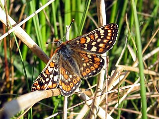
Swift's Hill is a 9.15-hectare (22.6-acre) biological and geological Site of Special Scientific Interest in Gloucestershire, notified in 1966 and renotified in 1984.

Salmonsbury Meadows is an 18-hectare (44-acre) biological and geological Site of Special Scientific Interest in Gloucestershire, notified in 1985. The site is listed in the 'Cotswold District' Local Plan 2001-2011 as a Key Wildlife Site (KWS).

Bull Cross, The Frith and Juniper Hill is a 42.33-hectare (104.6-acre) biological and geological Site of Special Scientific Interest in Gloucestershire, notified in 1954. The site is listed in the ‘Stroud District’ Local Plan, adopted November 2005, Appendix 6 as an SSSI and Regionally Important Geological Site (RIGS).
Shorn Cliff And Caswell Woods is a 69.2-hectare (171-acre) biological Site of Special Scientific Interest in Gloucestershire, notified in 1986. The site is listed in the 'Forest of Dean Local Plan Review' as a Key Wildlife Site (KWS).

Lippets Grove is a 5-hectare (12-acre) nature reserve in Gloucestershire. The site was leased from the Forestry Commission in 1987 and is managed by the Gloucestershire Wildlife Trust. The site is listed in the 'Forest of Dean Local Plan Review' as a Key Wildlife Site (KWS).

East Wood and is a 0.82-hectare (2.0-acre) nature reserve in Gloucestershire, England. The west site is 0.45-hectare (1.1-acre). The east site is 0.37-hectare (0.91-acre). It is part of a larger area of woodland called East Wood, which is adjacent to Oakhill Wood and Woolaston Wood (east). The site was leased from the Forestry Commission in 1986 and is managed by the Gloucestershire Wildlife Trust. The site is listed in the 'Forest of Dean Local Plan Review' as a Key Wildlife Site (KWS).
Ridley Bottom is a 1.1-hectare (2.7-acre) nature reserve in Gloucestershire. The site is listed in the 'Forest of Dean Local Plan Review' as a Key Wildlife Site (KWS).
Siccaridge Wood is a 26.6-hectare (66-acre) nature reserve in Gloucestershire. The site is listed in the ‘Stroud District’ Local Plan, adopted November 2005, Appendix 6 as a Key Wildlife Site (KWS).


