Little Avon River

Last updated

Little Avon River
Sturt Bridge - geograph.org.uk - 102063.jpg
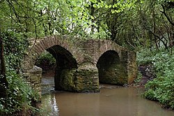
Sturt Bridge near Wickwar, a packhorse bridge on the Little Avon River
Gloucestershire UK relief location map.jpg
Red pog.svg
Location within Gloucestershire
Location
Country United Kingdom
Parts England
Region South West
Administrative areas Gloucestershire, South Gloucestershire
Physical characteristics
Source 
  location Horton, Gloucestershire, England
  coordinates 51°33′30″N2°21′12″W / 51.558373°N 2.353447°W / 51.558373; -2.353447
Mouth Berkeley Pill
  location
Severn Estuary, United Kingdom
  coordinates
51°41′58″N2°29′18″W / 51.69952°N 2.488404°W / 51.69952; -2.488404 Coordinates: 51°41′58″N2°29′18″W / 51.69952°N 2.488404°W / 51.69952; -2.488404

The Little Avon River is a small river partly in southern Gloucestershire and partly in South Gloucestershire. For much of its length it forms the boundary between the county of Gloucestershire and the unitary authority of South Gloucestershire. It rises to the east of Wickwar, near Horton, passes near Charfield, Stone and Berkeley, and enters the River Severn via Berkeley Pill. It was formerly navigable up to moorings at Berkeley, but a flood-prevention scheme, built in the 1960s, now prevents navigation more than a few hundred metres upstream.

Contents

Geology

The Little Avon River rises from a point upstream to the east of Wickwar [1] in Gloucestershire, flowing north-west for a total of 15 kilometres (9.3 mi), near Charfield, Stone and Berkeley, before finally joining the River Severn. The river runs through sandstone and clay, while the source water has been affected by the limestone from where it rises. The river starts as a steep course, with a natural riffle-pool sequence, before flattening out at Stone, where the river has been modified for used for irrigation. By the time the river reaches Berkeley, it is sheltered from the tide using tidal gates. [2]

Its tributaries include Ozleworth Brook, Dyers Brook through Wotton-under-Edge, Doverte Brook and Kilcott Brook. [3]

Ecology

Rare species of conservation interest including white-clawed crayfish, water voles, bullheads and eels are known to live in the catchment. [3] Ten species from the UK Biodiversity Action Plan have been recorded, as well as several from the IUCN Red List. [3]

The river is used as a fishery, controlled by Berkeley Estate Fishing Syndicate, which ensures that brown trout and grayling are in the river for fly fishing as well as standard coarse fishing species. [2]

Notable features

Grade II listed footbridge over the river Footbridge adjacent to road bridge, Ham, Berkeley (geograph 2293931).jpg
Grade II listed footbridge over the river

There is a footbridge over the Little Avon River which links Berkeley Castle to Berkeley Stables. It was built around the turn of the 19th century, with the main arch being about 8 metres (26 ft) wide and 3.5 metres (11 ft) above water level at its highest point. The pathway across the bridge is approximately 1.5 metres (4 ft 11 in) wide, with the total width of 2.5 metres (8 ft 2 in). The bridge was designated Grade II listed status on 9 September 1985. [4]

Related Research Articles

<span class="mw-page-title-main">River Severn</span> River in the United Kingdom

The River Severn, at 220 miles (354 km) long, is the longest river in Great Britain. It is also the river with the most voluminous flow of water by far in all of England and Wales, with an average flow rate of 107 m3/s (3,800 cu ft/s) at Apperley, Gloucestershire. It rises in the Cambrian Mountains in mid Wales, at an altitude of 2,001 feet (610 m), on the Plynlimon massif, which lies close to the Ceredigion/Powys border near Llanidloes. The river then flows through Shropshire, Worcestershire and Gloucestershire. The county towns of Shrewsbury and Gloucester and the City of Worcester lie on its course.

<span class="mw-page-title-main">South Gloucestershire</span> Unitary authority area in England

South Gloucestershire is a unitary authority area in the ceremonial county of Gloucestershire, South West England. Towns in the area include Yate, Chipping Sodbury, Thornbury, Filton, Patchway and Bradley Stoke, the latter three forming part of the northern Bristol suburbs. The unitary authority also covers many outlying villages and hamlets. The southern part of its area falls within the Greater Bristol urban area surrounding the city of Bristol.

<span class="mw-page-title-main">River Avon, Bristol</span> River in the south west of England

The River Avon is a river in the south west of England. To distinguish it from a number of other rivers of the same name, it is often called the Bristol Avon. The name 'Avon' is a cognate of the Welsh word afon, meaning 'river'.

<span class="mw-page-title-main">River Usk</span> River in Wales

The River Usk rises on the northern slopes of the Black Mountain, Wales, in the westernmost part of the Brecon Beacons National Park. Initially forming the boundary between Carmarthenshire and Powys, it flows north into Usk Reservoir, then east by Sennybridge to Brecon before turning southeast to flow by Talybont-on-Usk, Crickhowell and Abergavenny after which it takes a more southerly course.

<span class="mw-page-title-main">River Teme</span> River in Wales and England

The River Teme rises in Mid Wales, south of Newtown, and flows southeast roughly forming the border between England and Wales for several miles through Knighton before entering England in the vicinity of Bucknell and continuing east to Ludlow in Shropshire. From there, it flows to the north of Tenbury Wells on the Shropshire/Worcestershire border on its way to join the River Severn south of Worcester. The whole of the River Teme was designated as an SSSI by English Nature in 1996.

<span class="mw-page-title-main">River Camel</span> River in Cornwall, England

The River Camel is a river in Cornwall, England. It rises on the edge of Bodmin Moor and with its tributaries its catchment area covers much of North Cornwall. The river flows into the eastern Celtic Sea between Stepper Point and Pentire Point having covered about 30 miles, making it the second longest river wholly in Cornwall. The river is tidal upstream to Egloshayle and is popular for sailing, birdwatching and fishing. The name Camel comes from the Cornish language for 'the crooked one', a reference to its winding course. Historically the river was divided into three named stretches. Heyl was the name for the estuary up to Egloshayle, the River Allen was the stretch between Egloshayle and Trecarne, whilst the Camel was reserved for the stretch of river between its source and Trecarne.

<span class="mw-page-title-main">River Lugg</span> River in Radnorshire, Wales and Herefordshire, England

The River Lugg rises near Llangynllo in Radnorshire, Wales. It flows through the border town of Presteigne and then through Herefordshire, England, where it meets its main tributary, the River Arrow, to the south of Leominster. It flows into the River Wye downstream of Hereford at Mordiford, around 63 miles (101 km) from its source. Its name comes from a Welsh root, and means "bright stream".

<span class="mw-page-title-main">Charfield</span> Human settlement in England

Charfield is a village and civil parish in Gloucestershire, England, south-west of Wotton-under-Edge near the Little Avon River and the villages of Falfield and Cromhall. The parish includes the hamlet of Churchend.

<span class="mw-page-title-main">Sharpness</span> Human settlement in England

Sharpness is an English port in Gloucestershire, one of the most inland in Britain, and eighth largest in the South West. It is on the River Severn at grid reference SO669027, at a point where the tidal range, though less than at Avonmouth downstream, is still large.

<span class="mw-page-title-main">River Leach</span> River in England

The River Leach is a river tributary to the River Thames, in England which runs mostly in Gloucestershire. It is approximately 18 miles (29 km) long, springing from the limestone uplands of the Cotswolds. In parts of its course it becomes a seasonal bourn, only running above ground when there is sufficient rainfall. Despite its small size it gives its name to two towns and a pair of villages.

<span class="mw-page-title-main">Northavon (UK Parliament constituency)</span>

Northavon was, from 1983 until 2010, a constituency represented in the House of Commons of the Parliament of the United Kingdom. It elected one Member of Parliament (MP) by the first past the post system of election.

<span class="mw-page-title-main">Severn Estuary</span> Estuary and Site of Special Scientific Interest in Great Britain

The Severn Estuary is the estuary of the River Severn, flowing into the Bristol Channel between South West England and South Wales. Its high tidal range, approximately 50 feet (15 m), means that it has been at the centre of discussions in the UK regarding renewable energy.

<span class="mw-page-title-main">River Frome, Stroud</span> River in England

The River Frome, once also known as the Stroudwater, is a small river in Gloucestershire, England. It is to be distinguished from another River Frome in Gloucestershire, the Bristol Frome, and the nearby River Frome, Herefordshire. The river is approximately 25 miles (40 km) long.

<span class="mw-page-title-main">River Trym</span> Short river in the United Kingdom

The River Trym is a short river, some 4.5 miles (7.2 km) in length, which rises in Filton, South Gloucestershire, England. The upper reaches are culverted, some underground, through mostly urban landscapes, but once it emerges into the open it flows through a nature reserve and city parks before joining the tidal River Avon at Sea Mills. 18th-century water mills near the mouth gave the area its name.

The Bristol and Gloucester Railway was a railway company opened in 1844 to run services between Bristol and Gloucester. It was built on the 7 ftBrunel gauge, but it was acquired in 1845 by the 4 ft 8+12 instandard gauge Midland Railway, which also acquired the Birmingham and Gloucester Railway at the same time.

<span class="mw-page-title-main">Lower Woods</span>

Lower Woods is a 280.1-hectare (692-acre) biological and geological Site of Special Scientific Interest near the village of Wickwar, South Gloucestershire, notified in 1966 and renotified in 1985. The site area has increased at last revision in 1974 to a 284.1-hectare (702-acre) site. The site is a nature reserve managed by the Gloucestershire Wildlife Trust.

The Severn Valley is a rural area of the West Midlands region of England, through which the River Severn runs and the Severn Valley Railway steam heritage line operates, starting at its northernmost point in Bridgnorth, Shropshire and running south for 16 miles (26 km) to Ribbesford, a few miles south of Bewdley, Worcestershire in the Wyre Forest.

<span class="mw-page-title-main">River Boyd</span> River in England

The River Boyd is a river of some 7 miles (11 km) in length which rises near Dodington in South Gloucestershire, England. It is a tributary of the Bristol Avon, running in a southerly direction and joining near Bitton. The flow rate at Bitton is an average 19.8 cubic feet per second (0.56 m3/s). It was immortalised in the 1613 poem by John Dennys of Pucklechurch The Secrets of Angling, the earliest English poetical tract on fishing:

And thou sweet Boyd that with thy watry sway
Dost wash the cliffes of Deington and of Weeke
And through their Rockes with crooked winding way
Thy mother Avon runnest soft to seeke
In whose fayre streames the speckled Trout doth play
The Roche the Dace the Gudgin and the Bleeke
Teach me the skill with slender Line and Hooke
To take each Fish of River Pond and Brooke.

<span class="mw-page-title-main">Nind Nature Reserve</span>

Nind Nature Reserve is a 3.75-hectare (9.3-acre) nature reserve in Gloucestershire.

<span class="mw-page-title-main">Bow Brook</span> River in Worcestershire, England

The Bow Brook is a substantial brook that flows for 28.8 miles (46.3 km) through Worcestershire, England. It is a lower tributary of the River Avon which it joins near Defford downstream of Eckington Bridge. Its principal tributaries include the Stoulton, Dean, and Seeley brooks.

References

  1. Trobe-Bateman, E. LA. "Avon extensive urban survey archaeological assessment report" (PDF). South Gloucestershire Council. Retrieved 29 August 2016.
  2. 1 2 "Little River Avon" (PDF). The Wild Trout Trust. 2010. Retrieved 29 August 2016.
  3. 1 2 3 Clark, George (3 March 2021). "Assessing the status of the Little Avon headwaters - Bristol Avon Rivers Trust" . Retrieved 16 January 2023.
  4. Historic England. "FOOTBRIDGE OVER LITTLE AVON RIVER (1222153)". National Heritage List for England . Retrieved 29 August 2016.