
Cirencester is a market town in Gloucestershire, England, 80 miles (130 km) west of London. Cirencester lies on the River Churn, a tributary of the River Thames, and is the largest town in the Cotswolds. It is the home of the Royal Agricultural University, the oldest agricultural college in the English-speaking world, founded in 1840.

The Fosse Way was a Roman road built in Britain during the first and second centuries AD that linked Isca Dumnoniorum (Exeter) in the southwest and Lindum Colonia (Lincoln) to the northeast, via Lindinis (Ilchester), Aquae Sulis (Bath), Corinium (Cirencester), and Ratae Corieltauvorum (Leicester).
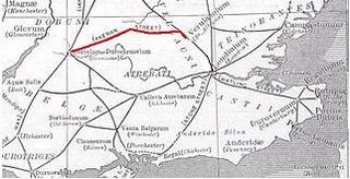
Akeman Street is a Roman road in southern England between the modern counties of Hertfordshire and Gloucestershire. It is approximately 117 kilometres (73 mi) long and runs roughly east–west.

The A46 is a major A road in England. It starts east of Bath, Somerset and ends in Cleethorpes, Lincolnshire, but it does not form a continuous route. Large portions of the old road have been lost, bypassed, or replaced by motorway development. Between Leicester and Lincoln the road follows the course of the Roman Fosse Way, but between Bath and Leicester, two cities also linked by the Fosse Way, it follows a more westerly course.
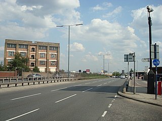
Western Avenue is part of the A40, a major road running in a north-westerly direction out of London. Western Avenue is approximately 10 miles (16 km) long from its junction with Old Oak Common Lane in East Acton.

The A419 road is a primary route between Chiseldon near Swindon at junction 15 of the M4 with the A346 road, and Whitminster in Gloucestershire, England near the M5 motorway. The A419 is managed and maintained by a private company, Road Management Group, on behalf of the UK Department for Transport.

The A417 is a main road in England running from Streatley, Berkshire to Hope under Dinmore, Herefordshire. It is best known for its section between Cirencester and Gloucester where it has primary status and forms part of the link between the major settlements of Swindon and Gloucester.

The A429 is a main road in England that runs in a north-northeasterly direction from junction 17 of the M4 motorway to Coventry in the West Midlands.

Kemble is a village in the civil parish of Kemble and Ewen, in the Cotswold district of Gloucestershire, England. Historically part of Wiltshire, it lies 4 miles (6.4 km) from Cirencester and is the settlement closest to Thames Head, the source of the River Thames. In 2020 it had an estimated population of 940. At the 2011 census the parish had a population of 1,036.

South Cerney is a village and civil parish in the Cotswold district of Gloucestershire, 3 miles south of Cirencester and close to the border with Wiltshire. It had a population of 3,074 according to the 2001 census, increasing to 3,464 at the 2011 census. It was founded in 999 by Saxon settlers, with a charter by King Aethelred II. In 2001 South Cerney was winner of the Bledisloe Cup for the best-kept village in Gloucestershire, having previously won the award in 1955.
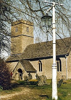
Coln Rogers is a village in the Cotswold district of the English county of Gloucestershire. It is included in the civil parish of Coln St. Dennis.

Long Newnton is a small village and civil parish in Gloucestershire, England, lying on the B4014 road between Malmesbury and Tetbury. It is near the SW end of the Cotswolds. The population of the parish was 211 at the 2011 census.
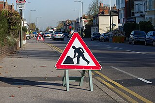
The A307 road runs 13.2 miles (21.2 km) through SW London and NW Surrey. It is primary at the north-east end; the remainder is non-primary, generally superseded in the mid-twentieth century in two stages by newer alignments of the Portsmouth Road, the Kingston bypass and Esher bypass of the A3, which runs along a slightly oblique axis.

The A4130 is a British A road which runs from a junction with the A404 at Burchetts Green (Maidenhead), Berkshire to the A417 at Rowstock in Oxfordshire. It passes through Henley-on-Thames, and Nettlebed, and bypasses Wallingford and Didcot.
Transport in Swindon, England, and the surroundings has directly contributed to the town's growth and the ingress of businesses and industries.

Thames Head is a group of seasonal springs that arise near the village of Coates in the Cotswolds, about three miles south-west of the town of Cirencester, in the county of Gloucestershire, England. The spring water comes from the limestone aquifers of the Cotswolds. One or more of these springs are traditionally identified as the source of the River Thames.

Coates is a village situated in Gloucestershire, England. It is around 3 miles (4.8 km) west of Cirencester and close to Cirencester Park, part of the Bathurst Estate. It is the nearest village to the source of the river Thames at Thames Head, and it is close to the course of the Foss Way or Fosse Way, the ancient Roman road. The nearest railway station is Kemble. The village population taken at the 2011 census was 507.

The Cirencester branch line was a five-mile-long single-track branch railway line in Gloucestershire, England that connected Cirencester to the main line at Kemble. It was opened by the Cheltenham and Great Western Union Railway in 1841. The main line was extended from Kemble to a junction near Gloucester in 1845, by the GWR which had taken over the C&GWUR. The branch supported a busy passenger and goods business, but these declined in the 1930s, and closure was threatened in the 1950s. To reduce costs and maintain the viability of the line, lightweight four-wheel diesel railbuses were introduced, and they proved popular. Nevertheless, the line's decline was inexorable, passenger service closed in 1964 and the goods service ending the following year.
Tetbury Road railway station was built by the Cheltenham & Great Western Union Railway to serve the Gloucestershire villages of Kemble and Coates, and the town of Tetbury.

Crudwell is a village and civil parish in north Wiltshire, England. The nearest towns are Malmesbury, about 4 miles (6.4 km) to the south-west, and Cirencester, Gloucestershire 8 miles (13 km) to the north-east. Also to the north-east is Cotswold Airport. Kemble village, about 4 miles (6.4 km) away, has the nearest railway station, with services to London Paddington and Gloucester.

