
Gower or the Gower Peninsula is in South West Wales and is the most westerly part of the historic county of Glamorgan, Wales. It projects towards the Bristol Channel. In 1956, the majority of Gower became the first area in the United Kingdom to be designated an Area of Outstanding Natural Beauty.

Gower electoral ward is an electoral ward in Britain. It is a ward of the City and County of Swansea, and comprises the western part of the Gower Peninsula. It lies within the UK Parliamentary constituency of Gower.
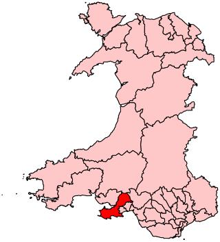
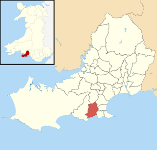
Gower is a constituency created in 1885 and represented in the House of Commons of the UK Parliament by one Member of Parliament (MP). Tonia Antoniazzi of the Labour Party became its MP after winning it from Conservative Byron Davies in the 2017 UK general election. Her party had previously represented the seat from 1909 until 2015.

Swansea Airport is located in the middle of Fairwood Common on the Gower Peninsula 6 miles (9.7 km) to the west of Swansea, Wales.
Killay is the name of a suburb and local government community in Swansea, Wales. Killay has its own community council. The village is set high above sea level, about 3.5 miles (5.6 km) west of Swansea city centre. It adjoins the town of Dunvant and the Tycoch area of Swansea. Gowerton lies to the north. The community had a population of 5,702 in 2011.

Bishopston is a large village and community situated on the Gower Peninsula, 6 miles (9.7 km) west south west of the centre of Swansea in South Wales.

Killay South was an electoral ward in the City and County of Swansea, Wales. The ward was mainly rural and consisted of some or all of the following areas: Dunvant, Ilston, Killay, Sketty and Upper Killay in the parliamentary constituency of Swansea West.

Pennard is the name of an electoral ward in the City and County of Swansea, Wales, United Kingdom. It is coterminous with the community of Pennard.

The electoral ward of Fairwood, City and County of Swansea, Wales, UK consists of some or all of the following areas: Dunvant, Upper Killay, Poundffald and Three Crosses in the parliamentary constituency of Gower.

Port Eynon is a village and community within the City and County of Swansea, Wales, on the far south tip of the Gower Peninsula within the designated Area of Outstanding Natural Beauty. The A4118 from Swansea city centre terminates here.

Parkmill is a village in the Gower Peninsula, South Wales, midway between the villages of Penmaen and Ilston, about eight miles (13 km) west of Swansea, and about one mile (1.5 km) from the north coast of the Bristol Channel. The village lies to the north of the A4118, the main South Gower road between Swansea and Port Eynon, in a wooded area, at the bottom of a valley.
Bishopston is the name of an electoral ward in the City and County of Swansea, Wales. Most of the area is rural consisting of farmland and small villages. The ward is named after the village of Bishopston which falls within the ward.

Gowerton is the name of an electoral ward in the county of Swansea, Wales, UK. It is named after Gowerton village which falls within the ward. The Gowerton community boundaries are coterminous with the ward.

The A4216 is a main road in Swansea, Wales.
The geology of the Gower Peninsula in South Wales is central to the area's character and to its appeal to visitors. The peninsula is formed almost entirely from a faulted and folded sequence of Carboniferous rocks though both the earlier Old Red Sandstone and later New Red Sandstone are also present. Gower lay on the southern margin of the last ice sheet and has been a focus of interest for researchers and students in that respect too. Cave development and the use of some for early human occupation is a further significant aspect of the peninsula's scientific and cultural interest.


