A4117 road

Last updated

UK road A4117.svg
A4117
A4117 Ludlow Road - geograph.org.uk - 2951084.jpg
A4117 at Angel Bank
Route information
Maintained by Shropshire Council &
Worcestershire County Council
Length15.0 mi (24.1 km)
Existed1927–present
History1922–27 classified as the B4200
1979 shortened by 1.0 mile (1.6 km) miles
Major junctions
East end A456 at Fingerpost, near Bewdley
Major intersectionsUK road A456.svg A456
UK road A49.svg A49
West end A49 T at the Ludlow bypass
Location
Country United Kingdom
Constituent country England
Primary
destinations
none
Road network
UK road A4115.svg A4115 UK road A4118.svg A4118

The A4117 is a single-carriageway 'A road' in western England, largely in Shropshire, which passes through part of the Wyre Forest and Clee Hills.

Contents

Route

It branches from the A456 2.2 miles (3.5 km) west of Bewdley, at a place called Fingerpost. Only the first 1.2 miles (1.9 km) of the route is in Worcestershire, [1] as immediately after passing through the small village of Far Forest it passes over the Lem Brook and into Shropshire. Heading in a roughly westerly direction, it passes through Cleobury Mortimer, Hopton Wafers and Clee Hill Village. The road's destination is the town of Ludlow, [2] where (since 1979) it ends at the Rocks Green roundabout on the A49 bypass. The route is 15.0 miles (24.1 km) long. [1]

Notable bridges are where the road crosses the River Rea on the eastern edge of Cleobury Mortimer, the Hopton Brook at Hopton Wafers, and also the Ledwyche Brook at Henley near Ludlow.

B road junctions

The A4117 has no 'A road' junctions other than at its two ends. It has five junctions with 'B roads' however, all of which are at a terminus of the B road in question.

To the east of Cleobury Mortimer there are junctions with the B4202 road (which heads southwards into north Worcestershire), and the B4201 and B4363 roads (which head northwards into east Shropshire). Further along, the B4214 road runs from a junction with the A4117 at Cleehill, down a considerable decline to Tenbury Wells. At Henley, near the Ludlow bypass, the B4364 road from Bridgnorth joins the A4117.

Terrain

The A4117 just east of Cleehill, where the road passes through a common with grazing sheep. A4117 over Titterstone Clee Hill.jpg
The A4117 just east of Cleehill, where the road passes through a common with grazing sheep.

The pass over the southern slopes of Titterstone Clee Hill reaches an altitude of 381 metres (1,250 ft), [2] making the A4117 Shropshire's highest A-road (the highest classified road is the B4368 at Anchor). Because of its situation and altitude, the A4117 is often affected by snow in winter. This upland part of the route is within the Shropshire Hills AONB.

Two notable inclines are named – the stretch from Hopton Wafers to Doddington is Hopton Bank; whilst the road from Clee Hill Village down to Henley is named Angel Bank. Hopton Bank had Shropshire's last remaining emergency escape lane (a sand trap for vehicles unable to brake) towards its lower end in Hopton Wafers; this was however removed in 2014 having become obsolete. [3]

The road passes through common land between Doddington and Clee Hill Village, and as such has cattle grids across the road to keep the openly grazing sheep within the common.

There is a public car park by the A4117 in Clee Hill Village, which affords a considerable view over the Teme valley below and further into the counties of Herefordshire and Worcestershire. At the car park is a toposcope and close by are public conveniences.

The road also passes right through the centre of the small market town of Cleobury Mortimer, which is a linear settlement along the road. This stretch is often congested.

Due to the hilly terrain and passing through the constrained streets through Cleobury Mortimer and Clee Hill Village, it is sometimes quicker (and more fuel efficient, especially for heavy goods vehicles) to take the A456 and A49 (i.e. via Woofferton) instead, if travelling between Bewdley and Ludlow; these two A roads are designated primary routes, whilst the A4117 is not.

Bus service

The 292 bus service (Ludlow-Bewdley-Kidderminster) operated by Diamond Bus, runs along the entire length of the road, providing regular public buses Monday to Saturday. [4]

Garages

The modern route as of 2018 has three filling stations, at Mawley Oak (the B4202 junction), in Cleobury Mortimer, and at Foxwood near Doddington. Another opened in 2017 at the original junction with the former route of the A49 in Ludlow.

A Sainsbury's supermarket was constructed at the junction with the A49 in 2021 [5] and originally an adjacent filling station was planned, but due to no interest from potential operators, as of 2024 there is a plan for a Costa Drive-thru instead. [6]

History

The Cornbrook Corner, between Doddington and Clee Hill Village; above can be seen quarrying operations, which use the A4117 for transporting extracted stone. Cornbrook - geograph.org.uk - 205706.jpg
The Cornbrook Corner, between Doddington and Clee Hill Village; above can be seen quarrying operations, which use the A4117 for transporting extracted stone.

The A4117 was created in 1927. Previously the majority of the route (from Henley to Fingerpost) was the B4200, and the remainder (between the A49 in Ludlow and Henley) was part of the B4364. (These B roads having been classified only five years earlier in 1922.) The route number 'B4200' has since been re-used for a short road in Wednesbury.

Prior to the opening of the A49 Ludlow bypass in 1979, the A4117 continued into the town along Henley Road and New Road to the old A49 route (passing under the Welsh Marches railway line at the foot of New Road). The junction with the A49 was at the Bridge Inn on Corve Street until the construction of Burway Bridge in the 1950s diverted the A49, after which the A4117 ran a little further (along part of the former A49 route), crossing the historic Corve Bridge.

This 1.0 mile (1.6 km) section from the pre-bypass A49 route (which has been re-classified as the B4361) along New Road and Henley Road to the Rocks Green roundabout is no longer a classified (A or B) route, however remains a busy local route (and the 292 bus route runs the length of Henley Road). [4]

Railway closures

The A4117 passed under the Tenbury and Bewdley Railway, which closed in 1962 to passengers and 1964 for freight, and the Cleobury Mortimer and Ditton Priors Light Railway, which finally closed in 1960, near to the former Cleobury Mortimer railway station, which was situated some distance from the town in the Wyre Forest and which was the junction of these two lines. The town, since these closures, has no railway links.

1962 saw the final closure of the railway link from Clee Hill Junction in Ludlow to the stone aggregate quarries on Clee Hill, meaning the quarrying operations there (which continue to the present-day) now rely on the A4117 road.

Milestones

One of the historic mileposts on the route. Old Milepost by the A4117, Clee Hill, Coreley parish (geograph 6072664).jpg
One of the historic mileposts on the route.

A number of historic milestones and mileposts (dated to the 18th and 19th centuries) continue to exist along the route; the remaining ones are in place between Far Forest and Cleobury Mortimer (marking distances to Cleobury and Bewdley) and again from Doddington to Henley (marking distances to Ludlow and Cleobury). [7]

Related Research Articles

<span class="mw-page-title-main">Ludlow</span> Town and civil parish in Shropshire, England

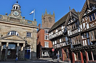
Ludlow is a market town and civil parish in Shropshire, England. It is located 28 miles (45 km) south of Shrewsbury and 23 miles (37 km) north of Hereford, on the A49 road which bypasses the town. The town is near the confluence of the rivers Corve and Teme.

<span class="mw-page-title-main">River Teme</span> River in Wales and England

The River Teme rises in Mid Wales, south of Newtown, and flows southeast roughly forming the border between England and Wales for several miles through Knighton before entering England in the vicinity of Bucknell and continuing east to Ludlow in Shropshire. From there, it flows to the north of Tenbury Wells on the Shropshire/Worcestershire border on its way to join the River Severn south of Worcester. The whole of the River Teme was designated as an SSSI by English Nature in 1996.

<span class="mw-page-title-main">Wyre Forest</span> Large, semi-natural woodland in England

Wyre Forest is a large, semi-natural woodland and forest measuring 26.34 square kilometres (10.17 sq mi) which straddles the borders of Worcestershire and Shropshire, England. Knowles Mill, a former corn mill owned by the National Trust, lies within the forest.

<span class="mw-page-title-main">A49 road</span> Road in England

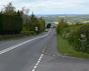
The A49 is an A road in western England, which traverses the Welsh Marches region. It runs north from Ross-on-Wye in Herefordshire via Hereford, Leominster, Ludlow, Shrewsbury and Whitchurch, then continues through central Cheshire to Warrington and Wigan before terminating at its junction with the A6 road just south of Bamber Bridge, near the junction of the M6, M65 and M61 motorways.

<span class="mw-page-title-main">Cleobury Mortimer</span> Human settlement in England

Cleobury Mortimer is a market town and civil parish in south-east Shropshire, England, which had a population of 3,036 at the 2011 census. It was granted a market charter by King Henry III in 1226.

<span class="mw-page-title-main">Rail transport in Shropshire</span> Overview of rail transport in Shropshire, England

The English county of Shropshire has a fairly large railway network, with 19 National Rail stations on various national lines; there are also a small number of heritage and freight lines, including the famous heritage Severn Valley Railway running along its eastern border with Worcestershire.

<span class="mw-page-title-main">Shropshire Hills National Landscape</span> Area of Outstanding Natural Beauty in England

The Shropshire Hills National Landscape is a designated Area of Outstanding Natural Beauty (AONB) in Shropshire, England. It is located in the south of the county, extending to its border with Wales. Designated in 1958, the area encompasses 802 square kilometres (310 sq mi) of land primarily in south-west Shropshire, taking its name from the upland region of the Shropshire Hills. The A49 road and Welsh Marches Railway Line bisect the area north–south, passing through or near Shrewsbury, Church Stretton, Craven Arms and Ludlow.

<span class="mw-page-title-main">Titterstone Clee Hill</span>

Titterstone Clee Hill, sometimes referred to as Titterstone Clee or Clee Hill, is a prominent hill in the rural English county of Shropshire, rising at the summit to 533 metres (1,749 ft) above sea level.

<span class="mw-page-title-main">A456 road</span> Road in the West Midlands

Known as the Hagley Road in Birmingham, the A456 is a main road in England running between Central Birmingham and Woofferton, Shropshire, south of Ludlow. Some sections of the route, for example Edgbaston near Bearwood, are also the route of the Elan Aqueduct which carries Birmingham's water supply from the Elan Valley.

<span class="mw-page-title-main">Rock, Worcestershire</span> Human settlement in England

Rock is a village and civil parish in the Wyre Forest District of Worcestershire, England, which lies south-west of Bewdley. It had a population of 2,366 in 2001.

<span class="mw-page-title-main">Cleehill</span> Human settlement in England

Cleehill is a village in south Shropshire, England. It is sometimes written as Clee Hill Village to avoid confusion. It lies in the civil parish of Caynham. The market towns of Ludlow and Cleobury Mortimer are both 5.5 miles (8.9 km) distant, Ludlow to the west and Cleobury to the east.

The Clee Hills are a range of hills in Shropshire, England near Ludlow, consisting of Brown Clee Hill 1,772 feet (540 m), the highest peak in Shropshire, and Titterstone Clee Hill 1,749 feet (533 m). They are both in the Shropshire Hills Area of Outstanding Natural Beauty.

<span class="mw-page-title-main">Woofferton</span> Human settlement in England

Woofferton is a village to the south of Ludlow, in Shropshire, England. It is one of Shropshire's most southerly villages and lies on the border with Herefordshire. It is part of the civil parish of Richard's Castle. The larger Herefordshire village of Brimfield is just over the border to the south.

<span class="mw-page-title-main">Hopton Wafers</span> Human settlement in England

Hopton Wafers is a small village and civil parish in south Shropshire, England. The population of the public parish at the 2011 census was 753. It is located on the A4117 road to the west of the market town of Cleobury Mortimer.

<span class="mw-page-title-main">Marches Way</span> Long-distance footpath in the United Kingdom

The Marches Way is a partially waymarked long-distance footpath in the United Kingdom. It runs for 351 kilometres (218 mi) through the Welsh–English borderlands, traditionally known as the Welsh Marches, and links the cities of Chester in the north and Cardiff in the south.

<span class="mw-page-title-main">Coreley</span> Human settlement in England

Coreley is a small, dispersed village and civil parish in south Shropshire, England, near to Clee Hill Village. It is situated approximately 30 miles (48 km) south west of Birmingham and just 4.5 miles (7.2 km) north east of Tenbury Wells. The name Corely comes from the Old English corn meaning a crane/heron and lēah meaning a forest/wood. This translates to crane wood/farmland.

CORELEY, a parish in Cleobury-Mortimer district, Salop; under the Clee Hills, 3½ miles NNE of Tenbury r[ailway]. station, and 5 WSW of Cleobury-Mortimer. Post town, Tenbury. Acres, 2,175. Rated property, £1,490. Pop[ulation]., 515. Houses, 106. The property is divided among a few. The living is a rectory in the diocese of Hereford. Value, £280.* Patron, Rev. J. Burnett Stuart. The church is of brick, and ancient, with tower and spire; and was reported in 1859 as bad.

<span class="mw-page-title-main">Burway Bridge</span>

Burway Bridge is a bridge in Ludlow, Shropshire, England. It takes the B4361 road across the River Corve.

<span class="mw-page-title-main">Cleobury North</span> Human settlement in England

Cleobury North is a civil parish and small village in south east Shropshire, England. It is situated on the B4364 southwest of the market town of Bridgnorth. To the north is the village of Ditton Priors and to the west is Brown Clee Hill, the county's highest hill.

Fingerpost is a hamlet and road junction in north Worcestershire, England, approximately 3 miles (4.8 km) west of Bewdley.

<span class="mw-page-title-main">Ledwyche Brook</span> River in south Shropshire, England

Ledwyche Brook is a minor river in south Shropshire, England. It is sometimes referred to as the River Ledwyche and spelled variously, including "Ledwich" or "Ledwych". The brook is a tributary of the River Teme.

References

  1. 1 2 Google maps
  2. 1 2 Ordnance Survey mapping
  3. Shropshire Star Shropshire motorists put faith in brakes as escape lane reaches end of road (21 May 2014)
  4. 1 2 Diamond Bus 292
  5. Shropshire Star New supermarket taking shape in Ludlow (1 June 2021)
  6. Shropshire Star Drive-thru Costa planned after supermarket site attracts no interest as petrol station (31 March 2024)
  7. Milestone Society Repository

52°23′02″N2°32′24″W / 52.384°N 2.54°W / 52.384; -2.54