
The A4 is a major road in England from Central London to Avonmouth via Heathrow Airport, Reading, Bath and Bristol. It is historically known as the Bath Road with newer sections including the Great West Road and Portway. The road was once the main route from London to Bath, Bristol and the west of England and formed, after the A40, the second main western artery from London.

The A34 is a major road in England. It runs from the A33 and M3 at Winchester in Hampshire, to the A6 and A6042 in Salford, close to Manchester City Centre. It forms a large part of the major trunk route from Southampton, via Oxford, to Birmingham, The Potteries and Manchester. For most of its length, it forms part of the former Winchester–Preston Trunk Road. Improvements to the section of road forming the Newbury Bypass around Newbury were the scene of significant direct action environmental protests in the 1990s. It is 151 miles (243 km) long.

Culham is a village and civil parish in a bend of the River Thames, 1 mile (1.6 km) south of Abingdon in Oxfordshire. The parish includes Culham Science Centre and Europa School UK. The parish is bounded by the Thames to the north, west and south, and by present and former field boundaries to the east. It is low-lying and fairly flat, rising from the Thames floodplain in the south to a north-facing escarpment in the north up to 260 feet (80 m) above sea level. The 2011 Census recorded its population as 453.

The A419 road is a primary route between Chiseldon near Swindon at junction 15 of the M4 with the A346 road, and Whitminster in Gloucestershire, England near the M5 motorway. The A419 is managed and maintained by a private company, Road Management Group, on behalf of the UK Department for Transport.

The A417 is a main road in England running from Streatley, Berkshire to Hope under Dinmore, Herefordshire. It is best known for its section between Cirencester and Gloucester where it has primary status and forms part of the link between the major settlements of Swindon and Gloucester.

The Thames Path is a National Trail following the River Thames from its source near Kemble in Gloucestershire to the Woolwich foot tunnel, south east London. It is about 185 miles (298 km) long. A path was first proposed in 1948 but it only opened in 1996.

Clifton Hampden is a village and civil parish on the north bank of the River Thames, just over 3 miles (5 km) east of Abingdon in Oxfordshire. Since 1932 the civil parish has included the village of Burcot, 1 mile (1.6 km) east of Clifton Hampden. The 2011 Census recorded the parish population as 662.

The A308 is a road in England in two parts. The first part runs from Central London to Putney Bridge. The second part runs from just beyond Putney Heath to Bisham, Berkshire. It traces four, roughly straight lines, to stay no more than 3 miles (4.8 km) from the Thames. It is a dual carriageway where it is furthest from that river, in Spelthorne, Surrey and forms one of the motorway spurs to the large town of Maidenhead. Other key settlements served are Fulham, Kingston (London), Staines upon Thames, Windsor and a minor approach to Marlow

Boulter's Lock is a lock and weir on the River Thames in England north-east of Maidenhead town centre, Berkshire. The present 1912-built lock replaces those at this point of the river to the immediate east dating from the late 16th century and that of 1772 built by the Thames Navigation Commission. The lock is on the western side of the north-south flowing reach between the A4094 Maidenhead to Cookham road and Ray Mill Island. The name is variably used for the immediate surrounding area.
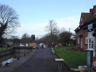
Clifton Lock is a lock on River Thames in Oxfordshire, England. It is located south of the village of Clifton Hampden and north of Long Wittenham. It is at the start of the Clifton Cut, which bypasses the river to the north of Long Wittenham. The lock was completed in 1822 by the Thames Navigation Commissioners.

The A329 is an east–west road in Southern England that runs from Wentworth in Surrey to Thame in Oxfordshire.

The A423 road is a primary A road in England in two sections. The main section leads from central Banbury to the A45 near Coventry.
The A446 is an A road in Zone 4 of the Great Britain numbering scheme.

The A4074 is a British A road from the Reading suburb of Caversham to the Heyford Hill roundabout on the Oxford Ring Road.

The A4130 is a British A road which runs from a junction with the A404 at Burchetts Green (Maidenhead), Berkshire to the A417 at Rowstock in Oxfordshire. It passes through Henley-on-Thames, and Nettlebed, and bypasses Wallingford and Didcot.

Benson Lock is a lock on the River Thames in England, close to Benson, Oxfordshire but on the opposite bank of the river. The first pound lock here was built by the Thames Navigation Commission in 1788 and it was replaced by the present masonry lock in 1870. The distance between Benson Lock and Cleeve Lock downstream is 6.5 miles (10.4 km) - the longest distance between locks on the River Thames.

Shillingford a hamlet on the north bank of the River Thames in Warborough civil parish in South Oxfordshire, England. Its homes are not quite with Warborough by way of one residential road. It lies mostly on the A4074 between Oxford and Reading, at the junction with the A329.

The A433 road is an A road and primary route in Gloucestershire, England.

The A42 is a major trunk road in the East Midlands region of the United Kingdom. It links junction 23A of the M1 motorway to junction 11 of the M42 motorway. The A42 is in effect a continuation of the M42, and its junctions are numbered accordingly.

