Snowdonia, or Eryri, is a mountainous region and national park in North Wales. It contains all 15 mountains in Wales over 3000 feet high, including the country's highest, Snowdon, which is 1,085 metres (3,560 ft) tall. These peaks are all part of the Snowdon, Glyderau, and Carneddau ranges in the north of the region. The shorter Moelwynion and Moel Hebog ranges lie immediately to the south.

Blaenau Ffestiniog is a town in Gwynedd, Wales. Once a slate mining centre in historic Merionethshire, it now relies much on tourists, drawn for instance to the Ffestiniog Railway and Llechwedd Slate Caverns. It reached a population of 12,000 at the peak development of the slate industry, but fell with the decline in demand for slate. The population of the community, including the nearby village Llan Ffestiniog, was 4,875 at the 2011 census: the fourth most populous in Gwynedd after Bangor, Caernarfon and Llandeiniolen. The population not including Llan is now only about 4,000.
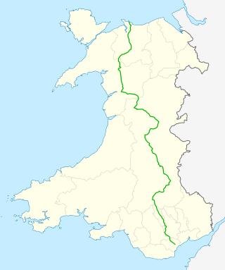
The A470 is a trunk road in Wales. It is the country's longest road at 186 miles (299 km) and links the capital Cardiff on the south coast to Llandudno on the north coast. While previously one had to navigate the narrow roads of Llanidloes and Dolgellau, both these market towns are now bypassed due to extensive road modernisation. The 26 miles (42 km) from Cardiff Bay to Merthyr Tydfil are mainly dual carriageway, but most of the route from north of Merthyr to Llandudno is single carriageway.

The Afon Mawddach is a river in Gwynedd, Wales, which has its source in a wide area SH820300 north of Dduallt in Snowdonia. It is 28 miles (45 km) in length, and is much branched; many of the significant tributaries are of a similar size to the main river. The catchment area is bounded to the east by the Aran Fawddwy massif and to the west and north by the Harlech dome which forms a watershed just south of Llyn Trawsfynydd.

The Cambrian Line, sometimes split into the Cambrian Main Line and Cambrian Coast Line for its branches, is a railway line that runs from Shrewsbury, England, westwards to Aberystwyth and Pwllheli in Wales. Passenger train services are operated by Transport for Wales Rail between the western terminals of Pwllheli, in Gwynedd, and Aberystwyth, in Ceredigion, and the eastern terminal at Shrewsbury, Shropshire, as part of the Wales & Borders franchise. The railway line is widely regarded as scenic, as it passes through the Cambrian Mountains in central Wales, and along the coast of Cardigan Bay in Snowdonia National Park.

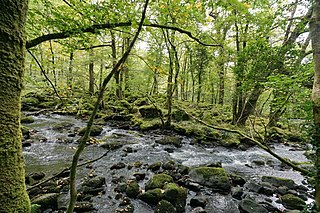
The River Dwyryd, is a river in Gwynedd, Wales which flows principally westwards; draining to the sea into Tremadog Bay, south of Porthmadog.
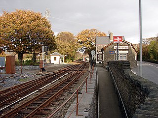
Minffordd railway station is a pair of adjacent stations on separate lines in Gwynedd, Wales. The mainline station opened as Minfford Junction on 1 August 1872 at the point where the then recently built Aberystwith and Welsh Coast Railway line from Dovey Junction to Pwllheli passes under the earlier narrow gauge Ffestiniog Railway. The latter was built in 1836 to carry dressed slate from Blaenau Ffestiniog to Porthmadog for export by sea, and had carried passengers from 1865 onwards. The station was renamed Minffordd in 1890.

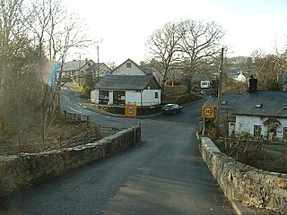
Maentwrog is a village and community in the Welsh county of Merionethshire, lying in the Vale of Ffestiniog just below Blaenau Ffestiniog, within the Snowdonia National Park. The River Dwyryd runs alongside the village. Its population of 585 in 2001 increased to 631 at the 2011 Census. The Community of Maentwrog includes the village of Gellilydan.
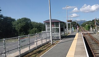
Tygwyn railway station is located at a level crossing on the A496 between Harlech and Talsarnau near the estuary of the Afon Dwyryd in Gwynedd, Wales.
The Aberystwith and Welsh Coast Railway was a standard gauge railway company, running a line along the west coast of Wales.

Maentwrog Road railway station was on the Great Western Railway's Bala Ffestiniog Line in Gwynedd, Wales.

The Afon Llyfnant, also known as the River Llyfnant, is a short river in Ceredigion, on the west coast of Wales. The river rises in the mountains south of Machynlleth, reaches the hill walk of Uwch Garreg and then plunges over a series of waterfalls known as Pistyll y Llyn, into a ravine, descending towards the River Dyfi near Dovey Junction railway station.
Llandecwyn is a hamlet near Penrhyndeudraeth in Gwynedd, Wales.

The Mawddach Group is a middle to upper Cambrian lithostratigraphic group in Gwynedd, Wales. The name is derived from the river known as the Afon Mawddach.
Gellilydan is a village in the Welsh county of Gwynedd, in Maentwrog community. It lies 4 miles (6 km) south-south-east of Blaenau Ffestiniog and 1.2 miles (2 km) north of Llyn Trawsfynydd and the disused Trawsfynydd nuclear power station. It is near the junction of two trunk roads, the A487 and the A470.
The first election to the Merionethshire County Council was held on 18 January 1889. It was followed by the 1892 election. The county was divided into numerous single member wards with two councillors elected to represent some of the urban areas.

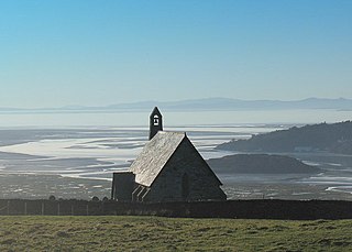
Llanfihangel-y-traethau was a parish in Ardudwy, Gwynedd, north-west Wales centred on a church of the same name in the village of Ynys. The original parish church was built in the 12th century on a tidal island. Later the land rose and connected the island to the mainland. Today it is part of the Bro Ardudwy ministry area, which includes Harlech, a few miles (kilometres) to the southwest, and Barmouth. The church has a window depicting Saint Tecwyn and is the start of the Saint Tecwyn's Way, a pilgrimage route ending at Saint Tecwyn's church in Llandecwyn.

The geology of Snowdonia National Park in North Wales is dominated by sedimentary and volcanic rocks from the Cambrian and Ordovician periods with intrusions of Ordovician and Silurian age. There are Silurian and Cenozoic sedimentary rocks on the park's margins. The succession was intensely faulted and folded during the Caledonian Orogeny. The region was uplifted as the North Atlantic Ocean opened during the Cenozoic. The current mountainous landscape arises from repeated glaciations during the Quaternary period.
The Afon Ysgethin is a short river in Gwynedd, Wales. Flowing entirely within Snowdonia National Park it rises beneath the peaks of Y Llethr and Diffwys within the Rhinogs mountain range and runs in a generally ESE direction towards Cardigan Bay.