
Snowdonia or Eryri, is a mountainous region in northwestern Wales and a national park of 823 square miles (2,130 km2) in area. It was the first to be designated of the three national parks in Wales, in 1951.

Blaenau Ffestiniog is a town in Gwynedd, Wales. Once a slate mining centre in historic Merionethshire, it now relies much on tourists, drawn for instance to the Ffestiniog Railway and Llechwedd Slate Caverns. It reached a population of 12,000 at the peak development of the slate industry, but fell with the decline in demand for slate. The population of the community, including the nearby village Llan Ffestiniog, was 4,875 in the 2011 census: the fourth most populous in Gwynedd after Bangor, Caernarfon and Llandeiniolen. The population not including Llan is now only about 4,000.

Trawsfynydd is a linear village in Gwynedd, Wales, near Llyn Trawsfynydd reservoir, and adjacent to the A470 north of Bronaber and Dolgellau and 10 km south of Blaenau Ffestiniog.

The River Dwyryd is a river in Gwynedd, Wales which flows principally westwards; draining to the sea into Tremadog Bay, south of Porthmadog.
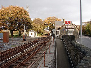
Minffordd railway station is a pair of adjacent stations on separate lines in Gwynedd, Wales. The mainline station opened as Minfford Junction on 1 August 1872 at the point where the then recently built Aberystwith and Welsh Coast Railway line from Dovey Junction to Pwllheli passes under the earlier narrow gauge Festiniog Railway. The latter was built in 1836 to carry dressed slate from Blaenau Ffestiniog to Porthmadog for export by sea, and had carried passengers from 1865 onwards. The station was renamed Minffordd in 1890.
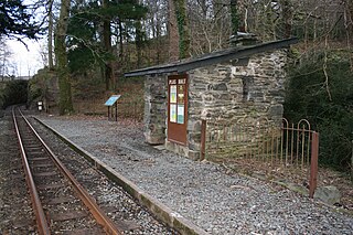
Plas Halt is an unstaffed halt on the narrow gauge Ffestiniog Railway in Wales, which was built in 1836 to carry dressed slate from Blaenau Ffestiniog to Porthmadog for export by sea.

Llyn Mair(Welsh for 'Mary's lake') is a 14-acre (5.7 ha) artificial lake near Maentwrog, in Gwynedd in North Wales. It lies in the area of Tan-y-Bwlch, a little above Plas Tan-y-Bwlch, and is in the catchment area of the River Dwyryd. It was created by William Edward Oakeley as a 21st birthday present for his daughter Mair and as a water supply. It was built in 1889, and the nearby smaller Llyn Hafod-y-Llyn dates from the same period.

Maentwrog Road railway station was on the Great Western Railway's Bala Ffestiniog Line in Gwynedd, Wales.

Festiniog railway station served the village of Llan Ffestiniog, Gwynedd, Wales. This station was one of many 19th century institutions in Wales to be given an anglicised name. Over the years, and especially since the Second World War, most have been rendered into Welsh or given both Welsh and English names, but Festiniog station closed before this happened. The village of Llan Ffestiniog - known locally simply as "Llan" - lies over 3 km south of the larger and more recent Blaenau Ffestiniog, and over three miles south by rail.

Manod railway station served the village of Manod which then stood on the southern edge of Blaenau Ffestiniog in Gwynedd, Wales.

Plas Tan y Bwlch in Gwynedd, Wales, is the Snowdonia National Park environmental studies centre, administered by the National Park Authority. It is located approximately 6 miles (9.7 km) east of the coastal town of Porthmadog, overlooking the valley of the River Dwyryd and the village of Maentwrog.

Tan-y-Bwlch lies in the Snowdonia National Park in North Wales and is primarily known as the location of Tan-y-Bwlch railway station, on the narrow gauge Ffestiniog Railway.

Rhyd is a small village in the Welsh County of Gwynedd, located on the B4410 road, halfway between Maentwrog and Llanfrothen. Situated on an elevated site within the Snowdonia National Park, the village has views of the Moelwyns, notably Moelwyn Bach. The village is located one mile from Tan-y-Bwlch railway station, one of the principal stops on the historic Ffestiniog Railway. Nearby is Llyn Mair.
Mining archaeology is a specific field well-developed in the British Isles during recent decades. A reason of ongoing interest in this field is the particular bond between regional history and the exploitation of metals. References to mines in the area exist in Strabo's works. However the first accomplished study on the topic was attempted by Oliver Davies in 1935. Other momentous researches were that of geologist John S. Jackson about mines in Ireland and Lewis, Jones in Dolaucothi goldmine in Wales, and the pioneering work of Ronald F. Tylecote. Moreover, in the 1980s and 1990s a new generation of amateurs and scientists began investigations in different locations in the British Isles, including Duncan James on the Great Orme's Head, Simon Timberlake with the Early Mines Research Group at sites in Wales and William O'Brien in Ireland.

Saint Twrog's Church is in the village of Maentwrog in the Welsh county of Gwynedd, lying in the Vale of Ffestiniog, within the Snowdonia National Park. It is in the Deanery of Ardudwy. It is designated by Cadw as a Grade II listed building.

Saint Twrog - feast day 26 June - was a 6th-century Welsh saint who founded the church at Maentwrog, having come to Wales early in the Age of the Saints.
William Edward Oakeley was the owner of the Oakeley Quarry in Blaenau Ffestiniog.
The A496 is a major coastal and mountainous road in southern Snowdonia.

The Oakeley Arms Hotel is a Grade II listed hotel near Maentwrog in North Wales. The original building dates back to the 17th century, and was once part of the nearby Tan-y-Bwlch Estate. Although its principal use has been as an inn, historically it has also been used as a post office, makeshift court house, polling station and police station.

On 10 September 1883 the Bala and Festiniog Railway (B&FR) and the Festiniog Railway (FR) opened what would be known as an interchange station in Blaenau Ffestiniog, Merionethshire, Wales. Merionethshire is now part of the county of Gwynedd.


