
Caernarfon is a royal town, community, and port in Gwynedd, Wales, with a population of 9,852. It lies along the A487 road, on the eastern shore of the Menai Strait, opposite the Isle of Anglesey. The city of Bangor is 8.6 miles (13.8 km) to the north-east, while Snowdonia fringes Caernarfon to the east and south-east. Carnarvon and Caernarvon are Anglicised spellings that were superseded in 1926 and 1974 respectively.

Blaenau Ffestiniog is a town in Gwynedd, Wales. Once a slate mining centre in the historic county of Merionethshire, it now relies heavily on tourists, drawn for instance to the Ffestiniog Railway and Llechwedd Slate Caverns. It was once the second largest town in North Wales, behind Wrexham. After reaching a population of 12,000 at the peak development of the slate industry, it fell with the decline in demand for slate. The population of the community of Ffestiniog, including the nearby village Llan Ffestiniog, was 4,875 in the 2011 census: the fourth most populous community in Gwynedd after Bangor, Caernarfon and Llandeiniolen. Blaenau's population is now only about 4,000.
The A487, officially also known as the Fishguard to Bangor Trunk Road, is a trunk road in Wales, that follows the coast from Haverfordwest, Pembrokeshire, in the south, to Bangor, Gwynedd, in the north.
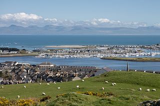
Pwllheli is a market town and community of the Llŷn Peninsula in Gwynedd, north-western Wales. It had a population of 4,076 in 2011 of whom a large proportion, 81%, are Welsh speaking. Pwllheli is the place where Plaid Cymru was founded. It is the birthplace of the Welsh poet Sir Albert Evans-Jones.
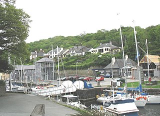
Y Felinheli, formerly known in English as Port Dinorwic, is a village, community and electoral ward beside the Menai Strait between Bangor and Caernarfon in Gwynedd, northwest Wales.

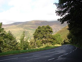
The Nantlle Valley is an area in Gwynedd, North Wales, characterised by its numerous small settlements.

Rhyd-ddu is a small village in Snowdonia, North Wales which is a starting point for walks up Snowdon, Moel Hebog, Yr Aran and the Nantlle Ridge.
Dinas is a large hamlet near Bontnewydd, Caernarfon, in Gwynedd, north-west Wales.
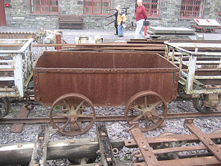
The Nantlle Railway was a Welsh narrow gauge railway. It was built to carry slate from several slate quarries across the Nantlle Valley to the harbour at Caernarfon for export by sea. The line provided a passenger service between Caernarfon and Talysarn from 1856 to 1865. It was the first public railway to be operated in North Wales.
The Carnarvonshire Railway was a railway connecting Caernarvon railway station with Afon Wen.

Groeslon railway station served the village of Groeslon, Gwynedd, Wales. It operated first as part of the Nantlle Tramway and afterwards as a railway under the auspices of several different companies. The station and line closed on 7 December 1964 as recommended in the Beeching Report.
Lôn Eifion is part of Lôn Las Cymru, the Welsh National Cycle Route, which is about 400 km (250 mi) long.

Penygroes is a village in Gwynedd, Wales. The village is located to the south of Caernarfon, and north of Porthmadog, by the A487 road. Penygroes' population stands at 1,793 at the 2011 census, of which 88% are Welsh-speaking, making it one of the most predominantly Welsh-speaking areas of the country. The population of Llanllyfni community, which includes Penygroes and Llanllyfni village, which practically adjoins Penygroes, plus Talysarn, is 4,135 according to the 2011 census.
Rhosgadfan is a Welsh village in the county of Gwynedd, formerly in the historic county of Caernarfonshire, and in the community of Llanwnda. It is notable as the birthplace of Kate Roberts, the greatest Welsh writer of the 20th century; her childhood home is now a museum.

Llanllyfni is a small village and a community in Gwynedd, Wales. It is in the historic county of Caernarfonshire. The community consists of the villages of Drws-y-coed, Nantlle, Nasareth, Nebo, Penygroes, Talysarn and the village of Llanllyfni itself. Penygroes, Llanllyfni and Talysarn are almost conjoined. As an electoral ward the 2011 census recorded a population of 1256. It is a largely Welsh-speaking village as 85% of the villagers speak Welsh as their first language. The community covers 43 square kilometres.
Bontnewydd is a small village and community with a population of 1,162 located on the A487 road 1+2⁄3 miles (2.7 km) south of Caernarfon in Gwynedd, Wales, close to the river Gwyrfai, 2 miles (3.2 km) from its outflow into Foryd Bay.
Tal-y-sarn is a village in the slate quarrying Nantlle Valley in Gwynedd, Wales, next to Penygroes. It is part of the community of Llanllyfni and includes some of Llandwrog. The ward had a population of 1,930 at the 2011 census, the built-up area having a population of 1,086.

Llanrug is a large village and community in Gwynedd, north-west Wales. It lies about 4 miles (6.4 km) to the east of Caernarfon, 7 miles (11 km) south of Bangor and 3 miles (4.8 km) northwest of Llanberis. It is the largest populated village in the Arfon area of Gwynedd, Wales. The old name of the village was Llanfihangel-y-Rug, derived from Eglwys Sant Mihangel, which is situated about half a mile west of the village. It has a Welsh-speaking community of approximately 88%, the highest in Wales, and a population of 2,911.
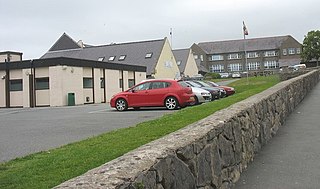
Ysgol Dyffryn Nantlle is a bilingual secondary school situated in Penygroes in Gwynedd, north Wales. The school serves the village of Penygroes and the surrounding rural area. There were 488 pupils enrolled at the school in 2015, including 69 in the sixth form.
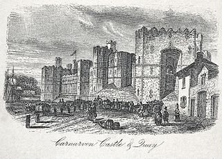
Carnarvon Castle railway station was opened in 1856 by the narrow gauge Nantlle Railway near the foot of what is today the Allt Y Castell which slopes down to Caernarfon's harbour area. It was the line's northern terminus and was the closest of Caernarfon's ultimately five stations to the historic town centre.


