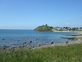
Criccieth, also spelled Cricieth ( ), is a town and community in Gwynedd, Wales, on the boundary between the Llŷn Peninsula and Eifionydd. The town is 5 miles (8 km) west of Porthmadog, 9 miles (14 km) east of Pwllheli and 17 miles (27 km) south of Caernarfon. It had a population of 1,826 in 2001, reducing to 1,753 at the 2011 census.

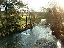
Llanystumdwy is a predominantly Welsh-speaking village, community and electoral ward in the Eifionydd area of Gwynedd in Wales. The village lies on the southern coast of the Llŷn Peninsula, with a beach facing Cardigan Bay, between Criccieth and Pwllheli at the point where the A497 road crosses the Afon Dwyfor.

Dwyfor Meirionnydd is a constituency of the House of Commons of the Parliament of the United Kingdom, held by Liz Saville Roberts of Plaid Cymru. The seat is bordered to the north by Bangor Aberconwy, to the south by Montgomeryshire and Glyndŵr, and to the east by Clwyd East. Until 2024, the seat shared the same boundaries with the Dwyfor Meirionnydd Welsh Assembly constituency, the latter of which still uses the borders established for the 2007 Welsh Assembly election.

Nant Gwynant is a valley in northern Wales. The A498 road descends 600 feet (180 m) into the valley in about two miles (3 km) from Pen-y-Gwryd; it follows the Nant Cynnyd, the Afon Glaslyn and alongside Llyn Gwynant, then beside the Nant Gwynant river to Llyn Dinas and passing below Dinas Emrys to Beddgelert. The road continues through the Aberglaslyn Pass to Porthmadog.

Tŷ Newydd is a historic house in Llanystumdwy, near Criccieth, in Gwynedd, north-west Wales. Since 1990 it has housed the National Writing Centre of Wales. The centre specialises in residential creative writing and retreats. The courses are in both the English and Welsh languages, and cover many genres, forms and styles. The centre also holds regular seminars and forums.

Chwilog is a village in Gwynedd, north Wales, and located on the Llŷn Peninsula. It is in the community of Llanystumdwy, near Criccieth, and in the medieval commote of Eifionydd, named after a 5th-century ruler. It is within the Dwyfor Meirionnydd constituency in the UK Parliament and in the Senedd. The name means 'abounding in beetles' and was perhaps transferred from an earlier name of the river.

The A498 is a 16-mile road between Pen-y-Gwryd and Porthmadog in North Wales.

The River Nevern is a river in Pembrokeshire, Wales. Its source is north of the village of Crymych and its length is about 11 miles (18 km) to its estuary at Newport, Pembrokeshire.

Afon Meillionen is a small river near Beddgelert in Gwynedd, north-west Wales.

Coleg Menai is a further education college located in Bangor, Gwynedd, Wales. The college has campuses in Parc Menai, Llangefni, Caernarfon and Holyhead.

The Lloyd George Museum is dedicated to the life and times of David Lloyd George, the Welshman who was Prime Minister of the United Kingdom from 1916 to 1922. It is located in Lloyd George's home village of Llanystumdwy, Wales, where he is buried, and is run by Gwynedd Council. It is normally open during the summer months and by appointment during the rest of the year.

The River Gavenny or sometimes the Gavenny River is a short river in Monmouthshire in south Wales. It rises 1 mile (1.6 km) southwest of the village of Llanvihangel Crucorney from springs near Penyclawdd Court, supplemented by springs in Blaen-Gavenny Wood and tributary streams there and within the Woodland Trust-owned Great Triley Wood. It flows south for about 4 miles (6.4 km) to its confluence with the River Usk towards the eastern end of Castle Meadows at Abergavenny. The town derives its English-language name from the Gavenny's confluence with the River Usk. Of the buildings on the banks of the river, the Gothic Decorated style church of St Teilo at Llantilio Pertholey is especially notable. Parts of the church date from the thirteenth century with multiple additions since. Blaengavenny Farm, the name of which signifies the 'head of the Gavenny', is a sixteenth-century farmhouse near the river's source.

The Afon Tarell is a river in Powys, Wales, which rises to the west of the Brecon Beacons in Brecon Beacons National Park and flows north, then north-east, for 12 miles (20 km) into the River Usk.

Dolbenmaen is a village and community in the Welsh county of Gwynedd, located in Eifionydd, of which it was the administrative centre until 1239. The community includes the villages of Bryncir, Cenin, Garndolbenmaen, Golan, Llanfihangel-y-Pennant, Penmorfa, Pentrefelin, Wern, Glan-dwyfach, and the hamlet of Prenteg. It has a population of 1,300, increasing slightly to 1,343 at the 2011 Census. The summit of Moel Hebog is shared between Beddgelert and Dolbenmaen. It is a sparsely populated area and covers nearly 100 square kilometres.
Gellilydan is a village in the Welsh county of Gwynedd, in Maentwrog community. It lies 4 miles (6 km) south-south-east of Blaenau Ffestiniog and 1.2 miles (2 km) north of Llyn Trawsfynydd and the disused Trawsfynydd nuclear power station. It is near the junction of two trunk roads, the A487 and the A470.

The Grave of David Lloyd George, stands on a bank of the Afon Dwyfor in the village of Llanystumdwy, Gwynedd, Wales. It commemorates Lloyd George who grew up in the village, was Prime Minister of the United Kingdom between 1916 and 1922, and died at Llanystumdwy in 1945. The grave and its setting were designed by Clough Williams-Ellis, the architect of Portmerion and a lifelong friend of Lloyd George. The grave comprises a boulder set in an oval enclosure, the walls of which bear two slate plaques recording Lloyd George's name and the years of his birth and death. It is a Grade II* listed structure.

The Afon Ffraw is a short river on the Isle of Anglesey, Wales. It arises at Llyn Coron and flows southwest for two miles along the northwestern margin of Twyn Aberffraw via the village of Aberffraw to Aberffraw Bay on the island's west coast. The river is tidal to a point just northeast of Aberffraw and is accompanied by the Wales Coast Path and Isle of Anglesey Coastal Path. Llyn Coron is fed by the Afon Gwna which rises near to Llangefni in the centre of Anglesey. The flow of the Ffraw is bolstered by the left-bank tributary, the Afon Frechwen and a larger, though unnamed right-bank tributary which rises near Gwalchmai. Pont Aberffraw is a bridge spanning the river constructed as a single stone arch in 1731. When the A4080 main coastal road was diverted onto a new line, the old bridge closed to traffic.

Lwyncelyn is a village in Ceredigion, Wales, situated on the A487 trunk road approximately 2.7 mi (4.3 km) southwest of the town of Aberaeron and 2 mi (3.2 km) northeast of the village of Llanarth. The village forms part of the community of Henfynyw with most of the village situated along the A487 trunk road and the unclassified road leading to the nearby hamlet of Oakford, Ceredigion.