
Llanrwst is a market town and community on the A470 road and the River Conwy, in Conwy County Borough, Wales, and the historic county of Denbighshire. It developed round the wool trade and became known also for the making of harps and clocks. Today, less than one mile from the edge of Snowdonia, its main pursuit is tourism. Notable buildings include almshouses, two 17th-century chapels, and the Parish Church of St Grwst, which holds a stone coffin of Llywelyn the Great. The 2011 census gave it a population of 3,323.
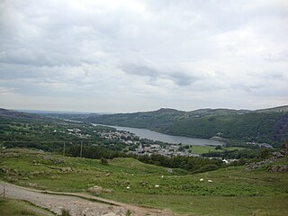
Llanberis is a village, community and electoral ward in Gwynedd, northwest Wales, on the southern bank of the lake Llyn Padarn and at the foot of Snowdon, the highest mountain in Wales. It is a centre for outdoor activities in Snowdonia, including walking, mountaineering, climbing, mountain biking and pony trekking, as well as water sports such as scuba diving. The community includes Nant Peris.

Tywyn, formerly spelled Towyn, is a town, community, and seaside resort on the Cardigan Bay coast of southern Gwynedd, Wales. It was previously in the historic county of Merionethshire. It is famous as the location of the Cadfan Stone, a stone cross with the earliest known example of written Welsh, and the home of the Talyllyn Railway.

Llanfairfechan is a town and community in the Conwy County Borough, Wales. It is known as a seaside resort and had a population at the 2001 Census of 3,755, reducing to 3,637 at the 2011 Census. The history of the area dates back to at least Roman times, as demonstrated by the discovery of a large second century milestone, which is now preserved in the British Museum.

Aberdyfi, also known as Aberdovey, is a village and community in Gwynedd, Wales, located on the northern side of the estuary of the River Dyfi.
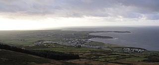
Nefyn is both a small town and a community on the northwest coast of the Llŷn Peninsula, Gwynedd, Wales. Nefyn is popular with visitors for its sandy beach, and has one substantial hotel. The A497 road terminates in the town centre.

Aberffraw is a village and community on the south west coast of the Isle of Anglesey, in Wales, by the west bank of the Afon Ffraw. The community includes Soar and Dothan. Located near the A4080 and the nearest rail station is Bodorgan.
Pentraeth is a village and community on the island of Anglesey, North Wales, at grid reference SH523786. The Royal Mail postcode begins LL75. The community population taken at the 2011 census was 1,178. The village itself having a population of 557.
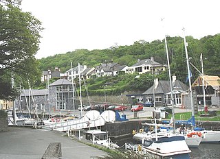
Y Felinheli, formerly known in English as Port Dinorwic, is a village and community beside the Menai Strait between Bangor and Caernarfon in Gwynedd, northwest Wales.
Waunfawr is a village and community, 6 kilometres (3.7 mi) SE of Caernarfon, near the Snowdonia National Park, Gwynedd, in Wales.

Clynnog Fawr, often simply called "Clynnog", is a village and community on the north coast of Llŷn Peninsula in Gwynedd, north-west Wales. It is in the historic county of Caernarfonshire. The community includes Pant Glas.

Llanuwchllyn is a village and community in Gwynedd, Wales, near the southern end of Bala Lake. It is one of the most sparsely populated communities in Wales.
Llanengan is a small village and community 1.2 mi (1.9 km) around Abersoch in Gwynedd in north-west Wales. It had a population of 2,024 at the 2001 census, which had been reduced to 1,989 at the 2011 Census. The popular seaside resort village of Abersoch falls within the community, as do the villages of Llangian, Mynytho, Machroes and Llanengan. The local public house is called the Sun.

Llanllyfni is a village and a community in Gwynedd, Wales. It is in the historic county of Caernarfonshire. The community consists of the villages of Drws-y-coed, Nantlle, Nasareth, Nebo, Penygroes, Talysarn and the village of Llanllyfni itself. Penygroes, Llanllyfni and Talysarn are almost conjoined. As an electoral ward the 2011 census recorded a population of 1256. It is a largely Welsh-speaking village as 85% of the villagers speak Welsh as their first language. The community covers 43 square kilometres.

Llangelynnin is a former parish in the Conwy valley, in Conwy county borough, north Wales. Today the name exists only in connection with the church, a school in the nearby village of Henryd, and the nearby mountain ridge, Craig Celynnin.

Tudweiliog is a small, predominantly Welsh-speaking village, community and electoral ward on the northern coast of the Llŷn Peninsula in the Welsh county of Gwynedd. It is in the historic county of Caernarfonshire. The population has risen from 801 in 2001 to 970 in 2011. The community includes the small settlement of Llangwnnadl. The community covers just over 35 square kilometres.

Bryncrug, sometimes spelt Bryn-crug, is a village and community in Gwynedd, Wales. Afon Fathew flows through the village and into the River Dysynni. The village is situated to the north east of the town of Tywyn, at the junction of the A493 and B4405 roads. Although the village is usually spelt Bryncrug in English, the community name uses the Welsh language version, Bryn-crug. The population of the community taken at the 2011 census was 622.

Llaneilian is a village and community in Anglesey, Wales. It is located in the north east of the island, 2.2 miles (3.5 km) east of Amlwch, 16.5 miles (26.6 km) north west of Menai Bridge and 12.5 miles (20.1 km) north of Llangefni. The community includes the villages and hamlets of Dulas, Llaneilian, Pengorffwysfa, Cerrig Man and Penysarn, Gadfa and Nebo, and at the 2001 census had a population of 1,192, decreasing slightly to 1,186 at the 2011 Census. The parish is crowned by its hill, Mynydd Eilian, a HuMP, popular with walkers and ramblers, and its beach, Traeth Eilian, which is popular with holidaymakers and for watersport activities. At the north easternmost point is Point Lynas,, while Ynys Dulas lies off the North East coast of the island, east of Dulas Bay.

Tal-y-llyn, or Talyllyn, is a small hamlet and former parish in Gwynedd, Wales, situated at the end of Tal-y-llyn Lake close to the village of Abergynolwyn. The parish covered an area of 36,000 acres (15,000 ha). The River Dysynni flows out of the lake at this point, flowing down to enter Cardigan Bay north of Tywyn. Another lake known as Llyn y Tri Greyenyn or Llyn Bach was formerly located close to the border with the parish of Dolgellau.

Castle Caereinion is a small village and community in Montgomeryshire, Powys, Wales upon the River Banwy, around 8 miles west of Welshpool, and 4 miles east of Llanfair Caereinion.


