| Llangybi | |
|---|---|
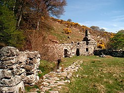 Ffynnon Gybi | |
 Llangybi Location within Gwynedd | |
| OS grid reference | SH427411 |
| Community | |
| Principal area | |
| Preserved county | |
| Country | Wales |
| Sovereign state | United Kingdom |
| Post town | PWLLHELI |
| Postcode district | LL53 |
| Dialling code | 01766 |
| Police | North Wales |
| Fire | North Wales |
| Ambulance | Welsh |
| UK Parliament | |
| Senedd Cymru – Welsh Parliament | |
Llangybi(English: Cybi's Church) is a village and former civil parish in the Eifionydd area of the Welsh county of Gwynedd, near Llanarmon. The parish was abolished in 1934 and divided between Llanystumdwy and Llannor. [1]


