
The River Dwyryd (Welsh : Afon Dwyryd), is a river in Gwynedd, Wales which flows principally westwards; draining to the sea into Tremadog Bay, south of Porthmadog.
The River Dwyryd (Welsh : Afon Dwyryd), is a river in Gwynedd, Wales which flows principally westwards; draining to the sea into Tremadog Bay, south of Porthmadog.
The Dwyryd rises in the hills to the north of Ffestiniog. At its most northern extent, water draining from Moelwyn Mawr drains into Llyn Ystradau, the outflow of which forms the source of the Afon Goedol. This is joined by the River Bowydd at grid reference: SH695438 . At Rhyd-y-Sarn, the Afon Goedol is joined by the Afon Teigl (originating from Manod Mawr). Thereafter, the river is called the Afon Dwyryd. Below Rhyd y Sarn by Pont Dolymoch, the river is joined by the Afon Cynfal which flows from the east down a deep wooded gorge which includes the spectacular Rhaeadr Cynfal (Cynfal waterfall) south of Ffestiniog. The main river then flows through a wide valley formed by glaciation, with a broad flat base formed from glacial moraines and riverine gravel deposits. The valley, the Vale of Ffestiniog, has much agriculture but is subject to routine winter flooding.
The Afon Tafarn-helyg has its confluence about one mile (1.6 km) further downstream. This tributary rises south of Gellilydan and just north of the reservoir of Llyn Trawsfynydd but does not receive any water from the reservoir.
There are a number of small lakes and reservoirs in the woodlands north of Plas Tan y Bwlch which also drain south into the river. These lakes include Llyn y Garnedd, Llyn Hafod y Llyn and Llyn Mair.
At Maentwrog the Dwyryd becomes a long and sandy tidal estuary, flowing under the road and railway line at Pont Briwet, before joining with the estuary of the River Glaslyn and then entering into Porthmadog Bay. The Afon y Glyn which drains the southwest catchment from Llyn Tecwyn Uchaf and Llyn Tecwyn Isaf enters the southern side of the Glaslyn estuary at the south end of a large extent of salt marsh known as Glastraeth (green beach) on its south bank and opposite the village of Portmeirion.
The whole of the river drains off igneous and ancient rocks of the Cambrian and Ordovician which are all base-poor. Much of the catchment has also been used for commercial forestry during the last hundred years. As a consequence, many of the tributaries are highly acidic as a result of atmospheric acidification. This has constrained the quality of the fishery and the biodiversity in many tributaries. Some of these problems have been exacerbated by past industrial activities including metal mining, slate mining, animal skin processing and the use by the army of a gunnery range with large amounts of emplaced metal cartridge shells.
The Afon Prysor is the largest tributary of the Dwyryd, entering its left bank in the tidal section downstream of Maentwrog. It rises in the hills to the east of Trawsfynydd and flows past the southern end of the village to enter Llyn Trawsfynydd, a large reservoir close to the A470. Prior to construction of the dam in the 1920s for hydroelectric power, the river had wandered across a broad upland marsh here known as Cors Goch. [1] It is the only inland water in the UK that has been used as a source of cooling water for a nuclear power station. The Afon Prysor resumes its course below the dam, to flow down to the Dwyryd through the steeply wooded valley of Ceunant Llennyrch which is at the core of a national nature reserve. Most of the flow from the reservoir is channelled through the hydro-electric power station close to Maentwrog; the flow then re-joins the Prysor just before the confluence.
At no point is the river deep enough to accommodate sea-going ships, but in the second half of the 18th century a number of quays were constructed west of Maentwrog from which small vessels took cargoes of timber and, increasingly, slate to be transferred to sea-going ships [2] in deeper water southwest of what would become Porthmadog, transferring to Porthmadog itself when its harbour was opened in 1824. The river was and remains so shallow that viable cargoes could only be carried at spring tides. Some of the quays remain to this day, [3] used by anglers. The opening of the Ffestiniog Railway in 1836 dealt a mortal blow to the Dwyryd traffic, which ended completely by 1860. [4]

Snowdonia, or Eryri, is a mountainous region and national park in northwestern Wales. It contains all 15 mountains in Wales over 3000 feet high, including the country's highest, Snowdon, which is 1,085 metres (3,560 ft) tall. These peaks are all part of the Snowdon, Glyderau, and Carneddau ranges in the north of the region. The shorter Moelwynion and Moel Hebog ranges lie immediately to the south.

Blaenau Ffestiniog is a town in Gwynedd, Wales. Once a slate mining centre in historic Merionethshire, it now relies much on tourists, drawn for instance to the Ffestiniog Railway and Llechwedd Slate Caverns. It reached a population of 12,000 at the peak development of the slate industry, but fell with the decline in demand for slate. The population of the community, including the nearby village Llan Ffestiniog, was 4,875 in the 2011 census: the fourth most populous in Gwynedd after Bangor, Caernarfon and Llandeiniolen. The population not including Llan is now only about 4,000.

Porthmadog, originally Portmadoc until 1974 and locally as "Port", is a coastal town and community in the Eifionydd area of Gwynedd, Wales, and the historic county of Caernarfonshire. It lies 5 miles (8 km) east of Criccieth, 11 miles (18 km) south-west of Blaenau Ffestiniog, 25 miles (40 km) north of Dolgellau and 20 miles (32 km) south of Caernarfon. The community population of 4,185 in the 2011 census was put at 4,134 in 2019. It grew in the 19th century as a port for local slate, but as the trade declined, it continued as a shopping and tourism centre, being close to Snowdonia National Park and the Ffestiniog Railway. The 1987 National Eisteddfod was held there. It includes nearby Borth-y-Gest, Morfa Bychan and Tremadog.

Tremadog Bay, is a shallow inlet of Cardigan Bay in North Wales. It comprises the area between Mochras in the east and the Trwyn Cilan headland of the Llŷn Peninsula in the west. The Sarn Badrig reef extends south-west from Mochras and forms a natural barrier between Tremadog Bay and Cardigan Bay proper.

The Afon Mawddach is a river in Gwynedd, Wales, which has its source in a wide area SH820300 north of Dduallt in Snowdonia. It is 28 miles (45 km) in length, and is much branched; many of the significant tributaries are of a similar size to the main river. The catchment area is bounded to the east by the Aran Fawddwy massif and to the west and north by the Harlech dome which forms a watershed just south of Llyn Trawsfynydd.

Trawsfynydd is a linear village in Gwynedd, Wales, near Llyn Trawsfynydd reservoir, and adjacent to the A470 north of Bronaber and Dolgellau and 10 km south of Blaenau Ffestiniog. It also neighbours the towns of Porthmadog and Bala.

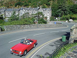
Maentwrog is a village and community in the Welsh county of Merionethshire, lying in the Vale of Ffestiniog just below Blaenau Ffestiniog, within the Snowdonia National Park. The River Dwyryd runs alongside the village. Its population of 585 in 2001 increased to 631 at the 2011 Census. The Community of Maentwrog includes the village of Gellilydan.

Afon Glaslyn is a river in Gwynedd, north-west Wales. While not of great significance in terms of its length, it is one of Gwynedd's primary rivers, and has greatly influenced the landscape in which it flows.

Llyn Mair is a 14-acre (5.7 ha) artificial lake near Maentwrog, in Gwynedd in North Wales. It lies in the area of Tan-y-Bwlch, a little above Plas Tan-y-Bwlch, and is in the catchment area of the River Dwyryd. It was created by William Edward Oakeley as a 21st birthday present for his daughter Mair and as a water supply. It was built in 1889, and the nearby smaller Llyn Hafod-y-Llyn dates from the same period.
The Bala and Festiniog Railway was a 4 ft 8+1⁄2 in, standard gauge, railway backed by the Great Western Railway (GWR) in north-west Wales. It connected Bala with Blaenau Ffestiniog.

Festiniog railway station served the village of Llan Ffestiniog, Gwynedd, Wales. This station was one of many 19th century institutions in Wales to be given an anglicised name. Over the years, and especially since the Second World War, most have been rendered into Welsh or given both Welsh and English names, but Festiniog station closed before this happened. The village of Llan Ffestiniog - known locally simply as "Llan" - lies over 3 km south of the larger and more recent Blaenau Ffestiniog, and over three miles south by rail.

Plas Tan y Bwlch in Gwynedd, Wales, is the Snowdonia National Park environmental studies centre, administered by the National Park Authority. It is located approximately 6 miles (9.7 km) east of the coastal town of Porthmadog, overlooking the valley of the River Dwyryd and the village of Maentwrog.

The Blaen y Cwm quarry was a slate quarry located east of Blaenau Ffestiniog in Wales. It was first worked in some time between 1813 and 1818 and sporadically after that until 1914. The quarry was connected to the Ffestiniog Railway at Duffws Station via the Rhiwbach Tramway.

Ceunant Llennyrch National Nature Reserve is one of several woodland reserves in the Vale of Ffestiniog in Gwynedd, Wales and runs from Llyn Trawsfynydd to the River Dwyryd, near the village of Maentwrog.
The A496 is a major coastal and mountainous road in southern Snowdonia.
Llandecwyn is a hamlet near Penrhyndeudraeth in Gwynedd, Wales.
Hugh Beaver Roberts was a solicitor, originally based in Bangor, Caernarfonshire who became an entrepreneur involved in the construction of narrow gauge railways and the ownership of slate quarries in North Wales during the second half of the 19th century.
52°58′32″N3°56′42″W / 52.97562°N 3.94496°W
