Gruffudd ap Cynan was King of Gwynedd from 1081 until his death in 1137. In the course of a long and eventful life, he became a key figure in Welsh resistance to Norman rule.

Merionethshire, or Merioneth, was one of the thirteen historic counties of Wales, in the north-west of Wales.

Gwyddelwern is a small village and community of 508 residents, reducing to 500 at the 2011 census, situated approximately 2 miles (3.2 km) north of Corwen in Denbighshire in Wales. Historically the village was part of the Edeyrnion district of Meirionnydd. Edeyrnion was part of the Glyndŵr district of Clwyd from 1974 to 1996, when the area became part of the principal area of Denbighshire. The village straddles the A494 road.
Cadfan ap Iago was King of Gwynedd. Little is known of the history of Gwynedd from this period, and information about Cadfan and his reign is minimal.

Aberffraw is a village and community on the south west coast of the Isle of Anglesey in Wales. The village is 9 miles from the island's county town, Llangefni, and is on the west bank of the Afon Ffraw. The community includes Soar and Dothan. It is on the A4080 and the nearest rail station is Bodorgan.

Abergwyngregyn is a village and community of historical note in Gwynedd, a county and principal area in Wales. Under its historic name of Aber Garth Celyn it was the seat of Llywelyn ap Gruffudd. It lies in the historic county of Caernarfonshire.
Trahaearn ap Caradog (1044–1081) was a King of Gwynedd. Trahaearn was a son of Caradog ap Gwyn, ruler of Arwystli, a small state, on the south-western border between Gwynedd and Powys. He was born in 1044 in Arwystli, and died in 1081 in Mynydd Carn in Pembrokeshire, at the Battle of Mynydd Carn.

Saint Beuno, sometimes anglicized as Bono, was a 7th-century Welsh abbot, confessor, and saint. Baring-Gould gives St Beuno's date of death as 21 April 640, making that date his traditional feastday. In the current Roman Catholic liturgical calendar for Wales, he is commemorated on 20 April, the 21st being designated for Saint Anselm.

Ysbyty Ifan is a small, historic village and community in the Conwy County Borough of Wales. The population in 2011 was 196 in 76 households ; over 79% of the population were able to speak Welsh. It has one of the smallest populations of any Welsh community, the smallest being Ganllwyd. It is in the electoral ward of Uwch Conwy.

Arfon was a mediaeval Welsh cantref in north-west Wales. It was the core of the kingdom of Gwynedd. Later it was included in the new county of Caernarfonshire, together with Llŷn and Arllechwedd under the terms of the Statute of Rhuddlan in 1284. The island of Anglesey faced it across the Menai Strait; to the east was the cantref of Arllechwedd, to the south the cantref of Eifionydd, and to the west was the cantref of Llŷn.

Tremeirchion is a small residential community in Denbighshire, Wales. It lies on the B5429 road, to the north east of Denbigh and to the east of St Asaph. The community includes the village of Rhuallt.

Ebenezer Thomas, better known to Welsh speakers by his bardic name of Eben Fardd, was a Welsh teacher and poet.
Culture and Society in Gwynedd during the High Middle Ages refers to a period in the History of Wales spanning the 11th, 12th, and 13th centuries. The High Middle Ages were preceded by the Early Middle Ages and followed by the Late Middle Ages. Gwynedd is located in the north of Wales.

Llanaelhaearn is a village and community on the Llŷn Peninsula in the county of Gwynedd, Wales. The community includes the larger village of Trefor and has a population of 1,067, increasing to 1,117 at the 2011 Census.

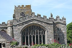
St Beuno's Church, Aberffraw is a 12th-century parish church in Anglesey, north Wales. A church was established in Aberffraw in the 7th century by St Beuno, who became the abbot of Clynnog Fawr, Gwynedd. St Beuno's may have been used as a royal chapel during the early Middle Ages, as the Princes of Gwynedd had a royal court in Aberffraw, as part of the Kingdom of Gwynedd. The oldest parts of the church date from the 12th century, although it was considerably enlarged in the 16th century when a second nave was built alongside the existing structure, with the wall in between replaced by an arcade of four arches. Restoration work in 1840 uncovered a 12th-century arch in the west wall, which may have been the original chancel arch or a doorway to a western tower that has been lost. The church also has a 13th-century font, some memorials from the 18th century, and two 18th-century copper collecting shovels.
A clas was a native Christian church in early medieval Wales. Unlike later Norman monasteries, which were made up of a main religious building supported by several smaller buildings, such as cloisters and kitchens, a clas was normally a single building. The building was run by a community of clergy and headed by an abod. Clasau were autonomous and were administered locally.

Saint Aelhaiarn or Aelhaearn was a Welsh confessor and saint of the British Church. He was a disciple of Saint Beuno. His feast day was usually observed on 2 November, although it is sometimes recorded as the 1st and is no longer observed by either the Anglican or Catholic church in Wales.

St Beuno's Church, Bettws Cedewain lies within the historic county of Montgomeryshire in Powys. The church occupies a prominent position overlooking the village of Bettws Cedewain, on the northern edge of the valley of the Bechan Brook which flows into the River Severn. Bettws is about 9 miles to the south-west of Welshpool. The church is a single-chambered structure with a western tower, set in a near-circular churchyard. A campanile or bellcote was added to the earlier tower in the early 16th century by the vicar, John ap Meredyth, whose memorial brass remains in the church to-day. The church was extensively rebuilt in 1868 under the supervision of the architect William Eden Nesfield. This included a complete rebuild of the upper part of the tower

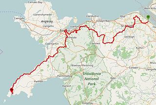
The North Wales Pilgrim's Way is a long-distance walking route in North Wales, running from near Holywell in the east to Bardsey Island in the west. The first half of the trail takes an inland route, with the second half following the north coast of the Llŷn Peninsula. It measures 133.9 miles (215 km) in length, and was officially launched at Porth y Swnt, Aberdaron on 10 July 2014.

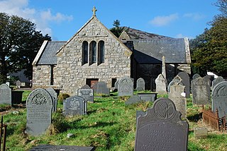
St Beuno's Church is a place of worship located in the village of Clynnog Fawr, Gwynedd, Wales. It belongs to the Church in Wales, an Anglican denomination, and is one of six churches in the parish of Beuno Sant Uwch Gwyrfai. It is adjacent to St Beuno's Chapel, to which it is connected, and approximately 322 metres north-east of Ffynnon Beuno. Beuno was a seventh-century Welsh abbot who founded a clas on the site of the present church and was later buried there.


