The Talyllyn Railway is a narrow-gauge railway in Wales running for 7+1⁄4 miles (12 km) from Tywyn on the Mid-Wales coast to Nant Gwernol near the village of Abergynolwyn. The line was opened in 1865 to carry slate from the quarries at Bryn Eglwys to Tywyn, and was the first narrow gauge railway in Britain authorised by Act of Parliament to carry passengers using steam haulage. Despite severe underinvestment, the line remained open, and in 1951 it became the first railway in the world to be preserved as a heritage railway by volunteers.

Tywyn, formerly spelled Towyn, is a town, community, and seaside resort on the Cardigan Bay coast of southern Gwynedd, Wales. It was previously in the historic county of Merionethshire. It is famous as the location of the Cadfan Stone, a stone cross with the earliest known example of written Welsh, and the home of the Talyllyn Railway.

The River Conwy is a river in north Wales. From its source to its discharge in Conwy Bay it is 55 kilometres (34 mi) long and drains an area of 678 square km. "Conwy" was formerly anglicised as "Conway."

Afon Mawddach is a river in Gwynedd, Wales, which has its source in a wide area SH820300 north of Dduallt in Snowdonia. It is 28 miles (45 km) in length, and is much branched; many of the significant tributaries are of a similar size to the main river. The catchment area is bounded to the east by the Aran Fawddwy massif and to the west and north by the Harlech dome which forms a watershed just south of Llyn Trawsfynydd.

Afon Tryweryn is a river in the north of Wales which starts at Llyn Tryweryn in the Snowdonia National Park and after 19 kilometres (12 mi) joins the river Dee at Bala. One of the main tributaries of the Dee, it was dammed in 1965 to form Llyn Celyn. The Tryweryn flooding forcibly removed residents of the village of Capel Celyn despite popular and political opposition in Wales. The resulting graffiti "Cofiwch Dryweryn" near Llanrhystud became and remains a popular icon of Welsh feeling. Water is stored in Llyn Celyn in winter when flows are high, and released over the summer to maintain the flow in the Dee (water from the Dee is used as the water supply for large areas of north-east Wales, and for the Wirral and much of Liverpool in England.

Afon Rheidol is a river in Ceredigion, Wales, 19 miles (31 km) in length. The source is Plynlimon. Receiving an average annual rainfall of 40 inches (1.02 m), Plynlimon is also the source of both the Wye and the Severn.
Afon Ogwen is a river in north-west Wales draining from some of the greatest peaks in Snowdonia before discharging to the sea on the eastern side of Bangor, Gwynedd.

River Neath is a river in south Wales running south west from the point at which its headwaters arising in the Brecon Beacons National Park converge to its mouth at Baglan Bay below Briton Ferry on the east side of Swansea Bay.

The River Dwyryd, is a river in Gwynedd, Wales which flows principally westwards; draining to the sea into Tremadog Bay, south of Porthmadog.

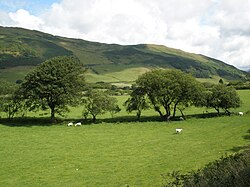
Abergynolwyn is a village in southern Gwynedd, Wales, located at the confluence of the Nant Gwernol and the Afon Dysynni. The population of the community which is named after the village of Llanfihangel-y-Pennant was 339 at the 2011 census.

Trehafod is a village and community in the Rhondda Valley, between Porth and Pontypridd in the county borough of Rhondda Cynon Taf, Wales, with a population of 698 in the 2011 census.(The earlier name Hafod was altered in 1905 to avoid confusion with Hafod near Swansea. Until then, Trehafod had been part of Hafod).

Tal-y-llyn Lake,, also known as Talyllyn Lake and Llyn Myngul, is a large glacial ribbon lake in Gwynedd, North Wales. It is formed by a post-glacial massive landslip damming up the lake within the glaciated valley. The hamlet of Talyllyn lies at the west end of the lake.
The Afon Crafnant is a tributary of the River Conwy, which is the main river of the Conwy valley in north-west Wales.
Afon Ddu is the name of several rivers in Snowdonia in north-west Wales:

Dolgoch railway station is a station on the Talyllyn Railway between Tywyn and Abergynolwyn, Gwynedd in north-Wales. It is 4 miles 72 chains from Tywyn Wharf. Unlike most places on the line, the station was built for tourist traffic, for visitors to the local Dolgoch Falls.

The River Dysynni is a river in mid Wales. Its source is the Tal-y-llyn Lake just south of the Cadair Idris massif and its mouth is in the Cardigan Bay area of the Irish Sea to the north of Tywyn. It measures about 16 mi (26 km) in length.

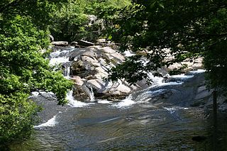
The Dolgoch Falls (also known as the Dol-goch falls, or the Dôl-goch falls are a series of three waterfalls near Tywyn in Gwynedd, North Wales.

Bryncrug, sometimes spelt Bryn-crug, is a village and community in Gwynedd, Wales. Afon Fathew flows through the village and into the River Dysynni. The village is situated to the north east of the town of Tywyn, at the junction of the A493 and B4405 roads. Although the village is usually spelt Bryncrug in English, the community name uses the Welsh language version, Bryn-crug. The population of the community taken at the 2011 census was 622.

Dolgoch slate quarry was a slate quarry in Mid Wales, approximately halfway between Bryn-crug and Abergynolwyn. The quarry was named after a nearby stream, the Nant Dolgoch. 'Dol goch' is Welsh for 'red meadow'.