Fort Belan

Last updated

Fort Belan
Fort Belan.jpg
Gwynedd UK location map.svg
Red pog.svg
Location within Gwynedd
General information
LocationDinlle Peninsula, Llanwnda
Town or city Gwynedd
Country Wales
Coordinates 53°07′21″N4°19′58″W / 53.12239°N 4.33269°W / 53.12239; -4.33269
Completed1775
Cost£30,000
Design and construction
Architect(s) Thomas Wynn, 1st Baron Newborough

Fort Belan (alternative: Belan Fort; pronounced: Bell-ann) [1] is a coastal fortress in North Wales. It is located opposite Abermenai Point, at the south-western end of the Menai Strait, on the coast of Gwynedd, in the parish of Llanwnda. Situated at the tip of the Dinlle Peninsula, the windblown, north-westernmost point of the Welsh mainland, the fort is cut off twice a day by the incoming tide. [1]

Contents

History

The fort was built in 1775 for a reported cost of £30,000 [2] [3] (equivalent to £3.7 million in 2019), [4] by Thomas Wynn, then MP for Caernarfonshire and later to become Lord Newborough. He was worried about the vulnerability of Britain's coastline to attack, particularly because of the recently begun American War of Independence. Fort Belan was the only purpose-built fort of the American Revolution on the eastern side of the Atlantic Ocean. [5] It guards a narrow passage of 35 m (115 ft) width. [6]

Cannons firing. Fort Belan 2.jpg
Cannons firing.

In the late 1780s, the barracks were used to ward off raiding American privateers from the Irish Sea but despite its military history, "no shots have been fired in anger from the fort". In the 1820s, the Wynn family turned it into a private fort for themselves, adding a small harbour for Spencer Wynn's steam yacht. Major construction works took place between 1824 and 1826. [7] The watchtower was built in the 1890s by Freddie Wynn, and it housed a telescope. [8]

In 1907, Sir Ralph Frankland-Payne-Gallwey described seeing a dock, workshops for repairing vessels, marine storehouses, winches, and cranes. [2] During World War II, the fort was again used for military purposes as the base for the Home Guard and two rescue launches. In the 1950s it was owned by Colonel Robert Vaughan Wynn. [9] The Wynn family sold the property in 1992 to the Blundells as a base for marine biology exploration. [5] [8] In 1996 the fort was reclassified as a Grade I listed building. [5] [10]

Architecture

Fort Belan Fort Belan 1.jpg
Fort Belan

The fort's innermost buildings are slightly taller than the 20-foot (6.1 m) stone walls. In the centre of the fort is a sheltered quadrangle; at one time, there were peacocks there. Fortified towers are located at either end of the courtyard. Each of the towers displays the two-headed eagle of the first Lord Newborough. Small two-storey houses that were used as officer and privates' quarters line the flanks, [1] commodious barracks for the Caernarvonshire county militia. [11] Approximately 24 cannons form a gun battery along the walls. One of the inner corridors is said to be the haunt of a phantom nursemaid. [1]

Present use

Fort Belan formerly housed a maritime museum and a pottery, [12] before being re-purposed as a self-catering holiday complex. Notably Princess Margaret stayed at the fort for the investiture of Prince Charles in 1969. [1]

Related Research Articles

<span class="mw-page-title-main">Chatham, Kent</span> Town in Kent, England

Chatham is a town located within the Medway unitary authority in the ceremonial county of Kent, England. The town forms a conurbation with neighbouring towns Gillingham, Rochester, Strood and Rainham.

<span class="mw-page-title-main">Haverfordwest</span> Human settlement in Wales

Haverfordwest is the county town of Pembrokeshire, Wales, and the most populous urban area in Pembrokeshire with a population of 14,596 in 2011. It is also a community, being the second most populous community in the county, with 12,042 people, after Milford Haven. The suburbs include the former parish of Prendergast, Albert Town and the residential and industrial areas of Withybush.

<span class="mw-page-title-main">West Riding of Yorkshire</span> One of the historic subdivisions of Yorkshire, England

The West Riding of Yorkshire is one of three historic subdivisions of Yorkshire, England. From 1889 to 1974 the administrative county, County of York, West Riding, was based closely on the historic boundaries. The lieutenancy at that time included the City of York and as such was named West Riding of the County of York and the County of the City of York.

<span class="mw-page-title-main">Pembroke, Pembrokeshire</span> Human settlement in Wales

Pembroke is both a town and a community in Pembrokeshire, Wales, with a population of 7,552. The names of both the town and the county have a common origin; both are derived from the Cantref of Penfro: Pen, "head" or "end", and bro, "region", "country", "land", which has been interpreted to mean either "Land's End" or "headland".

<span class="mw-page-title-main">Caerphilly</span> Town in South Wales

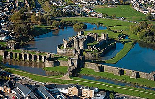
Caerphilly is a town and community in Wales. It is situated at the southern end of the Rhymney Valley.

<span class="mw-page-title-main">Clwyd</span> Preserved county of Wales

Clwyd is a preserved county of Wales, situated in the north-east corner of the country; it is named after the River Clwyd, which runs through the area. To the north lies the Irish Sea, with the English ceremonial counties of Cheshire to the east and Shropshire to the south-east. Powys and Gwynedd lie to the south and west respectively. Clwyd also shares a maritime boundary with Merseyside along the River Dee. Between 1974 and 1996, a slightly different area had a county council, with local government functions shared with six district councils. In 1996, Clwyd was abolished, and the new principal areas of Conwy County Borough, Denbighshire, Flintshire and Wrexham County Borough were created; under this reorganisation, "Clwyd" became a preserved county, with the name being retained for certain ceremonial functions.

<span class="mw-page-title-main">Baron Newborough</span> British noble title

Baron Newborough is a title that has been created twice in the Peerage of Ireland. Both titles are extant. The first creation came in 1716 in favour of George Cholmondeley, later 2nd Earl of Cholmondeley. See Marquess of Cholmondeley for further history of this creation. The second creation came in 1776 in favour of Sir Thomas Wynn, 3rd Baronet. He represented Caernarvonshire, St Ives and Beaumaris in the House of Commons and also served as Lord Lieutenant of Caernarvonshire. His son, the second Baron, represented Caernarvonshire in Parliament. He died unmarried and was succeeded by his younger brother, the third Baron. He served as High Sheriff of Anglesey in 1847. On his death the titles passed to his grandson, the fourth Baron. He died as a result of an illness contracted on active service during the First World War and was succeeded by his younger brother, the fifth Baron. When he died in 1957 the titles were inherited by his first cousin, the sixth Baron. He was the son of the Hon. Charles Henry Wynn, third son of the third Baron. He was succeeded in 1965 by his eldest son as the seventh Baron. As of 2022 the titles are held by the seventh Baron's son, the eighth Baron, who succeeded his father in 1998.

<span class="mw-page-title-main">Newborough, Anglesey</span> Human settlement in Wales

Newborough is a village in the south-western corner of the Isle of Anglesey in Wales; it is in the community of Rhosyr, which has a population of 2,169, increasing to 2,226 at the 2011 census. the village itself having a population of 892 with 68% born in Wales.

There have been two baronetcies created for persons with the surname Wynn, with the Gwydir family in the Baronetage of England and the Bodvean family in the Baronetage of Great Britain.

<span class="mw-page-title-main">Ruabon</span> Village in Wales

Ruabon is a village and community in Wrexham County Borough, Wales. The name comes from Rhiw Fabon, rhiw being the Welsh word for "slope" or "hillside" and Fabon being a mutation from St Mabon, the original church name, of earlier, Celtic origin. An older English spelling, Rhuabon, can sometimes be seen.

<span class="mw-page-title-main">Abermenai Point</span>

Abermenai Point is a headland in the southeast of the island of Anglesey in Wales. It is the southernmost point of the island and is the northern point of the western entrance of the Menai Strait.

<span class="mw-page-title-main">Thomas Wynn, 1st Baron Newborough</span> British politician

Thomas Wynn, 1st Baron Newborough, known as Sir Thomas Wynn, 3rd Baronet, from 1773 to 1776, was a British politician who sat in the House of Commons between 1761 and 1807.

Beaumaris was a parliamentary borough in Anglesey, which returned one Member of Parliament (MP) to the House of Commons of the Parliament of England from 1553, then to the Parliament of Great Britain from 1707 to 1800 and to the Parliament of the United Kingdom from 1801 to 1885, when the constituency was abolished. After 1832, the constituency was usually known as the Beaumaris District of Boroughs or simply the Beaumaris Boroughs.

<span class="mw-page-title-main">Glynllifon</span>

Glynllifon is the name of the old estate which belonged to the Barons Newborough, near the village of Llandwrog on the main A499 road between Pwllheli and Caernarfon in Gwynedd, Wales. The original mansion was until recently a privately owned Country House hotel and wedding venue.

Robert Charles Michael Vaughan Wynn, 7th Baron Newborough, DSC was a British peer and Royal Naval Volunteer Reserve officer who played a decisive role during the St. Nazaire Raid in 1942 where he commanded a Motor Torpedo Boat. Captured after his boat had to be abandoned, he was sent to Colditz after an escape attempt. He was repatriated after feigning illness.

Sir John Wynn, 2nd Baronet, of Glynllifon and Bodvean, Caernarvonshire and Melai, Denbighshire was a Welsh politician who sat in the House of Commons between 1740 and 1768.

<span class="mw-page-title-main">Castellau</span> Human settlement in Wales

Castellau is a hamlet, with a country house of the same name in the county borough of Rhondda Cynon Taf, South Wales. Historically, it lies within the parish of Llantrisant, just north-west of Beddau. It is connected with the history of the Trahernes. In 1988, Ysgol Castellau became the first Welsh medium education school to open in the southeast within new buildings.

<span class="mw-page-title-main">Maenan Abbey</span>

Maenan Abbey was a monastic religious house located in Maenan, Conwy, Wales. It is situated near Llanrwst.

Harristown is a townland in County Kildare on the River Liffey 2.5 miles (4.0 km) downstream from Kilcullen, just north of Brannockstown in the civil parish of Carnalway in the barony of Naas South. It is the site of a former borough and manor, and Harristown Borough was a borough constituency sending two MPs to the Irish House of Commons before the Acts of Union 1800. Harristown Common is a townland and former commonage north of Harristown proper and separated from it by the townlands of Dunnstown and Johnstown or Dunshane.

<span class="mw-page-title-main">Defensible Barracks, Pembroke Dock</span>

The Defensible Barracks at Pembroke Dock, is a Grade II*-listed, Victorian-era fortification and barracks in Pembrokeshire, Wales. It is a 20-sided stone fort surrounded by a dry moat with masonry walls. A parade ground occupies the centre of the fort. It was built in the mid-1840s to house the Royal Marines based in Pembroke Dockyard and to protect the dockyard.

References

  1. 1 2 3 4 5 Middleton, Christopher (5 March 2001). "Wales: Fortified by silence". The Daily Telegraph . London. Retrieved 8 September 2010.
  2. 1 2 Bindoff, Stanley T.; Roskell, John S.; Namier, Lewis (1982). The House of Commons: 1509–1558; 3, Members N - Z. Vol. 4. Boydell & Brewer. p. 671. ISBN   0-436-30420-1.
  3. Headley, Gwyn; Meulenkamp, Wim (1986). Follies: A National Trust Guide. Cape. ISBN   0-224-02105-2.
  4. United Kingdom Gross Domestic Product deflator figures follow the Measuring Worth "consistent series" supplied in Thomas, Ryland; Williamson, Samuel H. (2018). "What Was the U.K. GDP Then?". MeasuringWorth. Retrieved 2 February 2020.
  5. 1 2 3 "A Short History of Fort Belan". fortbelan.co.uk. Archived from the original on 17 October 2011. Retrieved 8 September 2010.
  6. "'FORT' BELAN?". fsgfort.com. Retrieved 8 September 2010.
  7. "Fort Belan Dockyard, Llandwrog". British Listed Buildings. Retrieved 8 September 2010.
  8. 1 2 "Friends' bid to restore Fort Belan watchtower". BBC. 17 June 2010. Retrieved 8 September 2010.
  9. Shaw, H. R. (1951). Country heritage: the stately homes of the north west counties and north Wales. Liverpool Daily Post and Echo limited.
  10. Cadw. "Fort Belan (Grade I) (3810)". National Historic Assets of Wales . Retrieved 2 April 2019.
  11. Lewis, Samuel (1833). A topographical dictionary of Wales: comprising the several counties, cities, boroughs, corporate and market towns, parishes, chapelries, and townships, with historical and statistical descriptions : illustrated by maps of the different counties ; and a map of Wales, shewing the principal towns, roads, railways, navigable rivers, and canals ; and embellished with engravings of the arms of the cities, bishopricks, corporate towns, and boroughs ; and of the seals of the several municipal corporations ; with an appendix describing the electoral boundaries of the several boroughs, as defined by the late act. Vol. 2. Lewis and Co.
  12. Petersen, Duncan; Joyce Huber, Jon Huber (2000). Britain on Backroads. On Backroads Series. Hunter Publishing, Inc. p. 214. ISBN   1-55650-895-6.

Coordinates: 53°07′21″N4°19′58″W / 53.12239°N 4.33269°W / 53.12239; -4.33269