Owain ap Gruffudd was King of Gwynedd, North Wales, from 1137 until his death in 1170, succeeding his father Gruffudd ap Cynan. He was called Owain the Great and the first to be styled "Prince of Wales", and the "Prince of the Welsh". He is considered to be the most successful of all the North Welsh princes prior to his grandson, Llywelyn the Great. He became known as Owain Gwynedd to distinguish him from the contemporary king of Powys Wenwynwyn, Owain ap Gruffydd ap Maredudd, who became known as Owain Cyfeiliog.

Gruffudd ap Cynan, sometimes written as Gruffydd ap Cynan, was King of Gwynedd from 1081 until his death in 1137. In the course of a long and eventful life, he became a key figure in Welsh resistance to Norman rule, and was remembered as King of all the Welsh and Prince of all the Welsh.

Hugh d'Avranches, nicknamed le Gros or Lupus, was from 1071 the second Norman Earl of Chester and one of the great magnates of early Norman England.

The Menai Strait is a narrow stretch of shallow tidal water about 25 km (16 mi) long, which separates the island of Anglesey from the mainland of Wales. It varies in width from 400 metres (1,300 ft) from Fort Belan to Abermenai Point to 1,100 metres (3,600 ft) from Traeth Gwyllt to Caernarfon Castle. It then narrows to 500 metres (1,600 ft) in the middle reaches and then it broadens again. At Bangor, Garth Pier, it is 900 metres (3,000 ft) wide. It then widens out, and the distance from Puffin Island to Penmaenmawr is about 8 kilometres (5.0 mi).

The Kingdom of Gwynedd was a Welsh kingdom and a Roman Empire successor state that emerged in sub-Roman Britain in the 5th century during the Anglo-Saxon settlement of Britain.

Menai Bridge is a town and community on the Isle of Anglesey in north-west Wales. It overlooks the Menai Strait and lies by the Menai Suspension Bridge, built in 1826 by Thomas Telford, just over the water from Bangor. With a population of 3,376, it is the fifth largest town on the island. The built-up area including Llandegfan had a population of 4,958.
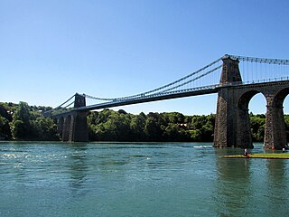
The Menai Suspension Bridge is a suspension bridge spanning the Menai Strait between the island of Anglesey and the mainland of Wales. Designed by Thomas Telford and completed in 1826, it was the world's first major suspension bridge. The bridge still carries road traffic and is a Grade I listed structure.

Abergwyngregyn is a village and community of historical note in Gwynedd, a county and principal area in Wales. Under its historic name of Aber Garth Celyn it was the seat of Llywelyn ap Gruffudd. It lies in the historic county of Caernarfonshire.
Newborough Warren near the village of Newborough (Niwbwrch) is a large dune and beach system of 2,269 hectares, approximately half of which is a conifer plantation. The whole area is designated as a Site of Special Scientific Interest and all of the site except the forestry is a national nature reserve.
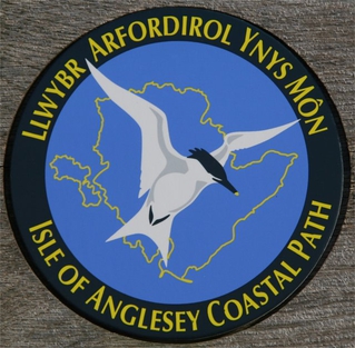
The Anglesey Coastal Path is a 200-kilometre (124 mi) long-distance footpath around the island of Anglesey in North Wales. The route is part of the Wales Coast Path.

The A4080 is a British A road which is located on the Island of Anglesey, Wales. It follows a very roundabout route from the A5 road at Llanfairpwllgwyngyll via Newborough and Rhosneigr back to the A55 and the A5 about 9 miles (14 km) south of Holyhead. In all the road is about 17 miles (27 km) long.

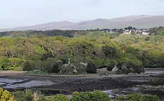
Llanfaes is a small village on the island of Anglesey, Wales, located on the shore of the eastern entrance to the Menai Strait, the tidal waterway separating Anglesey from the north Wales coast. Its natural harbour made it an important medieval port and it was briefly the capital of the kingdom of Gwynedd. Following Prince Madoc's Rebellion, Edward I removed the Welsh population from the town and rebuilt the port a mile to the south at Beaumaris. It is in the community of Beaumaris.

The Isle of Anglesey is a county off the north-west coast of Wales. It is named after the island of Anglesey, which makes up 94% of its area, but also includes Holy Island and some islets and skerries. The county borders Gwynedd across the Menai Strait to the southeast, and is otherwise surrounded by the Irish Sea. Holyhead is the largest town, and the administrative centre is Llangefni. The county is part of the preserved county of Gwynedd.
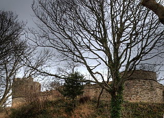
Castell Aberlleiniog is a motte and bailey fortress near the Welsh village of Llangoed on the Isle of Anglesey, built between 1080 and 1099 by Hugh d'Avranches, 1st Earl of Chester. It is about two miles distant from Beaumaris Castle, and was built atop a very steep hill.

The Battle of Anglesey Sound was fought in June or July 1098 on the Menai Strait, separating the island of Anglesey from mainland Wales. The battle was fought between Magnus Barefoot, King of Norway, and the Anglo-Norman earls Hugh of Montgomery and Hugh d'Avranches, and took place as part of Magnus Barefoot's expedition into the Irish Sea, which sought to assert Norwegian rule over the Kingdom of the Isles.

Afon Braint is a small tidal river on Anglesey, North Wales. There is a series of stepping stones near the village of Dwyran, and a Grade II bridge near Penmynydd. Until recently, there was an electoral ward named after the river.

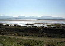
Lavan Sands is an intertidal sandbank found in the Menai Strait between Bangor, Gwynedd and Llanfairfechan, Wales. Totally underwater at high tide, at extreme low tides it measures 5.5-mile (8.9 km) east-west and 3.25-mile (5.23 km) north-south. At the western end is found another sandbank Bangor Flats and just north is the sandbank Dutchman's Bank. At low tide the Lavan Sands make the narrowest part of the Menai Strait, at Beaumaris, a mere 237 m (778 ft). The area is designated as an SSSI due in part to the large numbers of Eurasian oystercatchers that migrate there due to the freshwater streams that flow across it.
Angharad ferch Owain was a Queen of Gwynedd and wife of Gruffudd ap Cynan.