Llangelynnin, Conwy

Last updated

Llangelynnin ( Loudspeaker.svg Welsh pronunciation ; Welsh for The church of Celynnin) is a former parish in the Conwy valley, in Conwy county borough, north Wales. Today the name exists only in connection with the church, a school in the nearby village of Henryd, and the nearby mountain ridge, Craig Celynnin.

Contents

Llangelynnin Church, the main porch St Celynnin church - geograph.org.uk - 197112.jpg
Llangelynnin Church, the main porch

Llangelynnin Church (Welsh: Eglwys Llangelynnin) is possibly one of the remotest churches in Wales ( 53°14′45″N3°52′23″W / 53.2458°N 3.8730°W / 53.2458; -3.8730 (Llangelynnin Church) ), and is amongst the oldest; that at Llanrhychwyn, further up the valley, is a little older. The church is dedicated to Saint Celynnin, who lived in the 6th century and probably established the first religious settlement here. It lies at a height of about 280 metres (920 ft) feet, above the village of Henryd in the Conwy valley, in the shelter of Tal y Fan (610 metres, 2,001 ft), the mountain to the south-west.

A small and simple building, it probably dates from the 12th century (although some sources cite the 13th century), and was probably pre-dated by an earlier church of timber, or wattle and daub construction. Llangelynnin is also the name of the former parish, the primary school in nearby Henryd (Ysgol Llangelynnin). Celynnin's name is also carried by Craig Celynnin, a mountain ridge adjacent to the church.

St. Celynnin

Celynnin lived in the 6th century, and according to tradition was one of the sons of Helig ap Glanawg, a prince who lived at Llys Helig (in what is now known to a natural rock formation) [1] before the sea inundated the land off the coast of Penmaenmawr. It is said that Celynnin was related to Rhun, son of Maelgwn Gwynedd, Prince of Gwynedd, who is known to have ruled in the 6th century, and that he was also a brother to Rhychwyn, the saint associated with Llanrhychwyn church.

Location

A view from the south-east, by the gate Llangelynnin church and porch.jpg
A view from the south-east, by the gate

Next to the church lie the remains of an Iron Age hut circle, and some stories romantically suggest that this was where St. Celynin himself lived. It is also reputed to have been used as a cockfighting ring. The church is overlooked from the north-east by the adjacent crags of Cerrig-y-ddinas, the site of an Iron Age hillfort. These crags afford wide views down the Conwy valley to the sea, and up the valley as far as Dolgarrog.

Pathways

Many old paths lie in the area, and these routes would have been established at a time when the hills were considerably more wooded.

An old walled bridleway route leads east from the church, down through Parc Mawr, [2] an area of woodland now owned by the Woodland Trust, who are replacing the Forestry Commission's 1960s-planted conifers with native species. The path through the wood leads towards the valley bottom, and to the west a route leads towards Penmaenmawr, past the Bronze Age standing stones of Maen Penddu. To the south-west a path meets the important Neolithic route and Roman Road passing through Bwlch-y-Ddeufaen, which connected the Conwy valley to the north coast near Llanfairfechan, and places further westwards.

The church building

The porch was added in the 15th century, and features an unusual "squint window" in its east (right) wall. Repairs to the porch roof were made using yew wood, and therefore it is quite possible that these came from the churchyard, which at one time contained trees. The door hinges and threshold date from the 14th century, although the door itself is more recent.

The nave is the oldest part of the church, dating from the 12th century, and the present chancel was added later, probably in the 14th century. Originally the nave would not have been paved, as it is today, and indeed, the rear of the north chapel remains unpaved even today. The roof contains dark oak rafters.

The north transept was added in the 15th century and was known as Capel Meibion, the "men's chapel". The window at the back of the chapel was a more recent addition.

Opposite the north transept, a south transept was also added, probably in the 16th century. This was called Capel Eirianws (meaning "Plum Orchard", the name of a local farm), whose owner possibly had it built. This chapel was demolished in the 19th century, but some remains are still visible from outside.

The present east window dates from the 15th century, and replaced a smaller 14th century window.

Since demolition of the south chapel (and the gallery) in the 19th century, the church has changed little.

Artifacts

The twist-turned altar rails and the altar screen date from the 17th century. The removal of a pulpit to the left of the altar revealed inscriptions on the east wall, and further removal of whitewash revealed the Creed, the Lord's Prayer and the Ten Commandments, in Welsh. The inscription "Fear God and honour the King", together with scrollwork, can clearly be seen today, as can a skull and cross-bones! The Welsh version of the Lord's Prayer, on the sill, is hardly visible, after vandalism.

The remains of the rood screen in front of the more recent lectern date from the 14th century, and would have separated the nave from the chancel. The church once had a rood loft and gallery, and the remains of these can be seen in on the nave walls, and from the beam at the back of the church. The gallery was demolished in the 19th century.

The reader's desk possibly dates from the 16th century, although the door is more recent.

The wooden benches in the nave date from the 18th century, although at least one bench in the church dates from 1629. [3] One bench (at the front of the north chapel) still bears the initials R.O.B., this being the Reverend Owen Bulkeley, a former rector, who died in 1737. A church inventory of 1742 records a particular bench which was used by women only.

Just inside the church, on the wall, is a holy water stoup, used until the 19th century for making the sign of the Cross. At the back of the church is an octagonal font, which probably dates from the 13th or 14th century. The bell has no inscription and its date is therefore unknown.

On the wall in the nave is a bier, used to carry the dead to the churchyard.

Renovation

Major renovation of the church was carried out in 1932 and in 1987. This later renovation work was carried out under the guidance of Gerald Speechley, and a plaque in the church records this. He died three years later.

The churchyard

Llangelynnin Church, from outside the walled churchyard Llangelynnin Church and churchyard.jpg
Llangelynnin Church, from outside the walled churchyard
The walled Holy Well, with stone bench visible on the left Llangelynnin holy well.jpg
The walled Holy Well, with stone bench visible on the left

The churchyard is walled, with an arched entrance in the eastern wall. Today it is almost devoid of tree growth, but this was not always so.

The churchyard contains a fair number of gravestones, dating back to the 14th century. These graves were not dug in any uniform layout. Indeed, the rock outcrops to such a degree that finding space for graves has been a problem over the centuries.

The Holy Well

In the south-eastern corner of the churchyard is a well, Ffynnon Gelynin (sometimes known as "The Holy Well of St. Celynin"), a small walled rectangular pool, which was renowned for its power to cure sick children. One old story relates that parents would throw items of their sick child's clothing into the water. If the clothes floated their child would live. If they sank the child was destined to die of the illness. The well was once roofed over but this structure no longer exists. The walls around the well, and probably the benches too, were later additions made when the churchyard was restored. The presence of surface water at this elevation was probably the reason for its designation as a site for early settlement, and the holy well itself almost certainly predates the church.

Outside the churchyard

Outside the churchyard itself, close to the well, are the remains of a round building. A church terrier of 1742 refers to this, and to its use as a stable.

Beyond the south-east corner of the churchyard there was once an old inn, demolished in the 19th century.

Access to the church

Well-behaved visitors are welcome - the sign in the porch Llangylennin porch sign.jpg
Well-behaved visitors are welcome – the sign in the porch

Despite its remoteness, the church is well signposted from Henryd, which lies off the B5106 south of Conwy. The single track road is metalled up to the small car park below the church. The church is not named on the Ordnance Survey map, but lies at reference SH751737.

The church is open to visitors at most times. Only occasionally are services held in the church, in the summer and on special occasions.

The "new" church

Llangelynnin church was used regularly until 1840, when it closed following depopulation of the area. A new church was consequently built, carrying the same name, nearer the centres of population. This church is situated close to the 15th century Groes Inn (on the B5106 road), on the road which runs from the inn to the village of Rowen. Whereas the old church reflects a simple mediaeval design, the new church was designed by Thomas Jones of Chester in a much grander, lofty late Georgian style. Unusually, the tower has a square lower storey surmounted by an octagonal embattled upper stage. The original plans of 1839 still exist .

A plaque in the doorway refers to the "re-erection" of the building, implying perhaps that there was an earlier building on this site, but there is no evidence to this effect, and no gravestones pre-date 1839. The Religious Census of 1851 refers to it being erected in "1839 or 1840", but makes no reference to the Old Church.

This "new" church also eventually closed (in the 1980s), but the font from the church is now displayed by the altar in Llangelynnin old church. Llangelynnin "new" church is now the studio of David Chapman, a sculptor and artist.

Llangelynnin – The wider parish

The following extract comes from A Topographical Dictionary of Wales (1849) by Samuel Lewis :

LLANGELYNIN (LLAN-GELYNIN), a parish, in the union of Conway, hundred of LlêchWedd-Isâv, county of Carnarvon, North Wales, 3 miles (S. by W.) from Conway; containing 270 inhabitants. This parish, which derives its name from the dedication of its church to St. Celynin, who flourished towards the close of the sixth century, is situated at the north-eastern extremity of the county, bordering upon Denbighshire. A memorable battle was fought at Cymryd, in or near the parish, in the year 880, between the forces of Anarawd, Prince of North Wales, and those of Edred, Earl of Mercia, who attempted the conquest of the country. In this conflict Anarawd was completely victorious; he drove the Mercians from the field of battle, and continued to pursue them until they were finally expelled from the principality: the victory was called Dial Rhodri, or "Roderic's revenge," as Anarawd thus fully avenged the slaughter of his father Roderic in a descent of the Saxons upon Anglesey. The village, which is small, is beautifully situated in a fertile vale under the mountain called Tàl-y-Van. The surface of the parish is mountainous, the lands partially inclosed and cultivated, the soil various, and the surrounding scenery marked with features rather of boldness than of beauty. The living is a discharged rectory, rated in the king's books at £7; patron, the Bishop of Bangor. The incumbent's tithes have been commuted for a rent-charge of £250, and the glebe comprises five acres: a rent-charge of £5 is paid to the parish-clerk. The church is a small ancient edifice, in a state of considerable dilapidation. There are places of worship for Independents and Wesleyan Methodists; a day school in connexion with the Church, and a Sunday school belonging to the Independents. The Rev. Launcelot Bulkeley, in 1718, bequeathed £60, the interest to be paid to four widows, who are appointed at a vestry, and regularly receive the donation.

Notes

  1. Bird, Eric (2010). Encyclopedia of the World's Coastal Landforms. Springer. ISBN   978-1402086380.
  2. "Parc Mawr". Woodland Trust. Retrieved 26 October 2021.
  3. "Drysau Agored 2006 – Dyddiau Treftadaeth Ewropeaidd" [Open Doors 2006 – European Heritage Days](PDF) (in Welsh). Conwy County Borough Council. Archived from the original (PDF) on 24 June 2015. Retrieved 23 June 2015.

Related Research Articles

<span class="mw-page-title-main">Llanrhychwyn</span> Hamlet in Wales

Llanrhychwyn is a hamlet in Conwy county borough, Wales. It lies in the Conwy valley, less than a mile south of Trefriw, and a mile north-west of Llanrwst. Today neighbouring Trefriw is a village with a population of around 600, but in the time of Llywelyn Fawr, and up to the early 19th century, Llanrhychwyn was larger than Trefriw, which consisted simply of "a few houses here and there". Indeed, even today both Trefriw and Llanrhychwyn lie within the parish of Llanrhychwyn. The area around Llanrhychwyn had a population of only 178 in 2011.

Nant Conwy was a rural district in the administrative county of Caernarfonshire from 1934 to 1974. The district was formed by a County Review Order, combining the areas of Geirionydd Rural District with most of Conwy Rural District and part of Ogwen Rural District. The name is derived from Nant Conwy, an historic cwmwd of the Kingdom of Gwynedd in the cantref of Arllechwedd.

<span class="mw-page-title-main">Henryd</span> Human settlement in Wales

Henryd is a village and community on the western slopes of the Conwy valley in Conwy county borough, north Wales. It lies about 2 miles (3.2 km) south of Conwy, off the B5106 road. At the 2001 census, it had a population of 594, increasing to 715 at the 2011 census.

Helig ap Glanawg is a legendary figure described in various accounts dating to at least as early as the 13th century as a 6th-century prince who lived in North Wales.

<span class="mw-page-title-main">St Mary and All Saints' Church, Great Budworth</span> Church in Cheshire, England

St Mary and All Saints Church is in the centre of the village of Great Budworth, Cheshire, England. It is an active Anglican parish church in the diocese of Chester, the archdeaconry of Chester and the deanery of Great Budworth. The church is recorded in the National Heritage List for England as a designated Grade I listed building. Clifton-Taylor includes it in his list of 'best' English parish churches. Richards describes it as "one of the finest examples of ecclesiastical architecture remaining in Cheshire". The authors of the Buildings of England series express the opinion that it is "one of the most satisfactory Perpendicular churches of Cheshire and its setting brings its qualities out to perfection".

<span class="mw-page-title-main">St Lawrence's Church, Stoak</span> Church in Cheshire, England

St Lawrence's Church is in the village of Stoak, Cheshire, England,. The church is recorded in the National Heritage List for England as a designated Grade II* listed building. It is an active Anglican parish church in the diocese of Chester, the archdeaconry of Chester, the deanery of Wirral South and the Ellesmere Port team ministry.

<span class="mw-page-title-main">St Columba's Church, St Columb Minor</span> Church

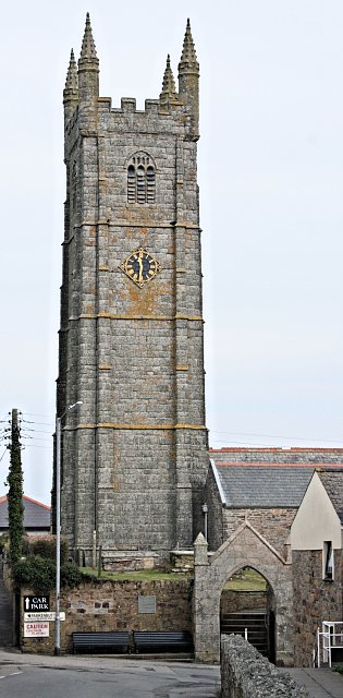
St Columb Minor Church is a late 15th-century Church of England parish church Diocese of Truro in St Columb Minor, Cornwall, United Kingdom

<span class="mw-page-title-main">Llangelynnin, Gwynedd</span> Human settlement in Wales

Llangelynnin is a small village and community near Tywyn, Gwynedd, Wales. Although the village is usually known as Llangelynnin in English, the community name used was Llangelynin though now its also "Llangelynnin".

<span class="mw-page-title-main">St Materiana's Church, Tintagel</span> Church

The Parish Church of Saint Materiana at Tintagel is a Church of England parish church in the Church of England Diocese of Truro in Cornwall, England, UK. It stands on the cliffs between Trevena and Tintagel Castle and is listed Grade I.

<span class="mw-page-title-main">St Peulan's Church, Llanbeulan</span> Church in Wales

St Peulan's Church, Llanbeulan is a redundant Anglican church in Llanbeulan, in Anglesey, north Wales. The nave, which is the oldest part of the building, dates from the 12th century, with a chancel and side chapel added in the 14th century. The church has a font of early date, possibly from the first half of the 11th century: one historian has said that it would initially have been used as an altar and that "as an altar of the pre-Norman period it is a unique survivor in Wales and, indeed, in Britain".

<span class="mw-page-title-main">St Baglan's Church, Llanfaglan</span> Church in Gwynedd, Wales

St Baglan's Church, Llanfaglan, is a redundant church in the parish of Llanfaglan, Gwynedd, Wales. It is designated by Cadw as a Grade I listed building, and is under the care of the Friends of Friendless Churches. It stands in an isolated position in a field some 150 metres (164 yd) from a minor road.

<span class="mw-page-title-main">Dwygyfylchi</span> Village in Wales

Dwygyfylchi is a village in Conwy County Borough, Wales. It is part of the community of Penmaenmawr which has a population of 4,353. The electoral ward of Capelulo which includes Dwygyfylchi had a population of 1,485 in 2011. It forms part of the historic county of Caernarfonshire.

<span class="mw-page-title-main">St Gallgo's Church, Llanallgo</span> Church in Wales

St Gallgo's Church, Llanallgo is a small church near the village of Llanallgo, on the east coast of Anglesey, north Wales. The chancel and transepts, which are the oldest features of the present building, date from the late 15th century, but there has been a church on the site since the 6th or early 7th century, making it one of the oldest Christian sites in Anglesey. Some restoration and enlargement took place during the 19th century.

<span class="mw-page-title-main">St Beuno's Church, Trefdraeth</span> Church in Wales, UK

St Beuno's Church, Trefdraeth is the medieval parish church of Trefdraeth, a hamlet in Anglesey, north Wales. Although one 19th-century historian recorded that the first church on this location was reportedly established in about 616, no part of any 7th-century structure survives; the oldest parts of the present building date are from the 13th century. Alterations were made in subsequent centuries, but few of them during the 19th century, a time when many other churches in Anglesey were rebuilt or were restored.

<span class="mw-page-title-main">St Edern's Church, Bodedern</span> Church in Wales

St Edern's Church, Bodedern is a medieval parish church in the village of Bodedern, in Anglesey, north Wales. Although St Edern established a church in the area in the 6th century, the oldest parts of the present building date from the 14th century. Subsequent alterations include the addition of some windows in the 15th century, and a chancel, transept and porch in the 19th century, when the nave walls were largely rebuilt. Stained glass was also inserted into the windows of the chancel and transept.

<span class="mw-page-title-main">St Mary's Church, Llanfair-yn-y-Cwmwd</span> Church in Wales

St Mary's Church, Llanfair-yn-y-Cwmwd is a small medieval parish church near the village of Dwyran, in Anglesey, north Wales. The building probably dates from the 15th century, with some alterations. It contains a 12th-century carved stone font and a 13th-century decorated coffin lid. The bell is inscribed with the year of its casting, 1582. The historian Henry Rowlands was vicar of St Mary's in the late 17th and early 18th centuries. Maurice Wilks, who invented the Land Rover, is buried in the churchyard.

<span class="mw-page-title-main">St Laurence's Church, Morland</span> Church in Cumbria, England

St Laurence's Church is in the village of Morland, Cumbria, England. It is an active Anglican parish church in the deanery of Appleby, the archdeaconry of Carlisle, and the diocese of Carlisle. Its benefice is united with those of St Mary, Thrimby, St Barnabas, Great Strickland, and St Cuthbert, Cliburn. The church is recorded in the National Heritage List for England as a designated Grade I listed building. It has the only Anglo-Saxon tower in Cumbria.

<span class="mw-page-title-main">St Peter's Church, Llanbedrgoch</span> Church in Wales

St Peter's Church, Llanbedrgoch, is a small medieval parish church near the village of Llanbedrgoch in Anglesey, north Wales. The oldest parts of the building date from the 15th century; it was extended in the 17th century and restored twice in the 19th century. The doorway is decorated with carvings of two human heads, one wearing a mitre. The church contains a reading desk made from 15th-century bench ends, one carved with a mermaid holding a mirror and comb.

<span class="mw-page-title-main">Saint Rhychwyn</span>

Rhychwyn was a 6th century saint of North Wales and the patron saint of Llanrhychwyn.

<span class="mw-page-title-main">North Wales Pilgrim's Way</span> Long-distance walking route in north Wales

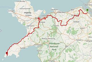
The North Wales Pilgrim's Way is a long-distance walking route in North Wales, running from near Holywell in the east to Bardsey Island in the west. The first half of the trail takes an inland route, with the second half following the north coast of the Llŷn Peninsula. It measures 133.9 miles (215 km) in length, and was officially launched at Porth y Swnt, Aberdaron on 10 July 2014.

References