Snowdonia is a mountainous region in northwestern Wales and a national park of 823 square miles (2,130 km2) in area. It was the first to be designated of the three national parks in Wales, in 1951. It contains the highest peaks in the United Kingdom outside Scotland.
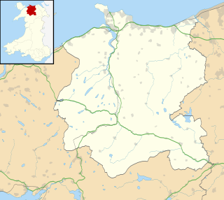
Conwy County Borough is a unitary authority area in North Wales.

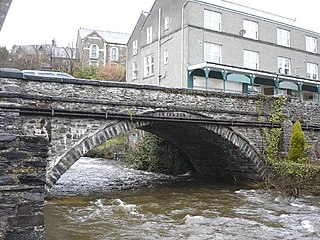
Llanrwst is a small market town and community on the A470 road and the River Conwy, in Conwy County Borough, Wales and in the historic county of Denbighshire. Llanrwst developed around the wool trade and became known also for the making of harps and clocks. Today, less than a mile from the edge of Snowdonia, its main industry is tourism. Notable buildings include almshouses, two 17th-century chapels, and the Parish Church of St Grwst, which holds a stone coffin of Llywelyn the Great. The 2011 census gave the town a population of 3,323.

Trefriw is a village and community in Conwy County Borough, Wales. It lies on the river Crafnant in North Wales, a few miles south of the site of the Roman fort of Canovium, sited at Caerhun. At the last three censuses the population of the community has been recorded as 842 in 1999, 915 in 2001, and 783 in 2011.

The River Conwy is a river in north Wales. From its source to its discharge in Conwy Bay it is 55 kilometres (34 mi) long and drains an area of 678 square km. "Conwy" was formerly Anglicised as "Conway."

The River Dwyryd is a river in Gwynedd, Wales which flows principally westwards; draining to the sea into Tremadog Bay, south of Porthmadog.

Llyn Cwellyn is a reservoir in North Wales which supplies drinking water to parts of Gwynedd and Anglesey. It lies on the Afon Gwyrfai in Nant y Betws between Moel Eilio and Mynydd Mawr in the northern part of Snowdonia National Park. It has an area of 215 acres (0.87 km2), and is over 120 ft (37 m) deep. At the southern end is the small village of Rhyd Ddu.
Gwydir Forest, also spelled Gwydyr, is located in Conwy county borough and the Snowdonia National Park in Wales. It takes its name from the ancient Gwydir Estate, established by the John Wynn family of Gwydir Castle, which owned this area.

Llanrhychwyn is a hamlet in Conwy county borough, Wales. It lies in the Conwy valley, less than a mile south of Trefriw, and a mile north-west of Llanrwst. Today neighbouring Trefriw is a village with a population of around 600, but in the time of Llywelyn Fawr, and up to the early 19th century, Llanrhychwyn was larger than Trefriw, which consisted simply of "a few houses here and there". Indeed, even today both Trefriw and Llanrhychwyn lie within the parish of Llanrhychwyn. The area around Llanrhychwyn had a population of only 178 in 2011.

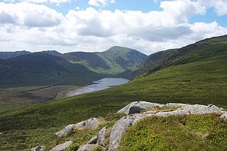
Llyn Cowlyd is the deepest lake in northern Wales. It lies in the Snowdonia National Park at the upper end of Cwm Cowlyd on the south-eastern edge of the Carneddau range of mountains, at a height of 1,164 feet (355 m) above sea level. The lake is long and narrow, measuring nearly 2 miles (3 km) long and about a third of a mile wide, and covers an area of 269 acres (1.1 km2). It has a mean depth of 109 feet (33 m) and at its deepest has given soundings of 229 feet (70 m), this being some 45 ft (14 m) greater than its natural depth, the water surface having been raised twice by the building of dams.
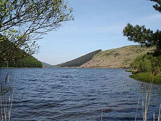
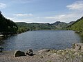
Llyn Geirionydd lies in a valley in North Wales where the northern edge of the Gwydyr Forest meets the lower slopes of the Carneddau mountains. The lake is almost a mile long and covers an area of 45 acres (180,000 m2), but is never any deeper than 50 ft (15 m) according to Jehu's survey. The lake can be reached by car from Trefriw or Llanrwst in the Conwy valley, the lane passing through the hamlet of Llanrhychwyn, or from the road through the Gwydir Forest. Access is not particularly easy by either route, but this has not stopped the lake being the only one designated in Snowdonia to permit power boats and water skiing. Many visitors also walk to the lake from the village of Trefriw or from the neighbouring lake of Llyn Crafnant, which runs parallel to it, but a mile distant, the two being separated by Mynydd Deulyn, “mountain of the two lakes”.

Llyn Ogwen is a ribbon lake in north-west Wales. It lies alongside the A5 road between two mountain ranges of Snowdonia, the Carneddau and the Glyderau. Somewhat unusually, the county boundary at this point is drawn so that the lake itself lies in the county of Gwynedd, but all the surrounding land lies in Conwy County Borough.

Dolgarrog is a village and community in Conwy County Borough, in Wales, situated between Llanrwst and Conwy, very close to the Conwy River. The village is well known for its industrial history since the 18th century and the Eigiau dam disaster, which occurred in 1925. The population was 414 at the 2001 Census, increasing to 446 at the 2011 Census. The community extends up to, and includes part of, Llyn Cowlyd in the Carneddau.
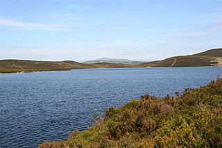
Llyn Eigiau is a lake on the edge of the Carneddau range of mountains in Snowdonia, Conwy, Wales. The name Eigiau is thought to refer to the shoals of fish which once lived here. Early maps refer to it as Llynyga. It is thought that a small number of Arctic char exist in the lake after they were transferred here from Llyn Peris, and certainly it is one of the few lakes in Wales to have its own natural brown trout. The lake is surrounded by mountains including Pen Llithrig y Wrach.
The Afon Crafnant is a tributary of the River Conwy, which is the main river of the Conwy valley in north-west Wales.

The River Geirionydd is a river in Snowdonia, North Wales. It is a tributary of the River Crafnant, which flows over the Fairy Falls waterfall in Trefriw, and thence on into the River Conwy, which is the main river of the Conwy valley.
Llyn Conwy (SH780462) is a lake in the county of Conwy in central north Wales. It is the source of the River Conwy which, on flowing south out of the lake, swings round to then generally flow in a northerly direction for a distance of some 27 miles (43 km) to its discharge in Conwy Bay. Llyn Conwy lies at a height of about 1,488 ft, with a maximum depth of 16 feet, and is by far the biggest lake of the Migneint moors, an extensive area of blanket mire with high rainfall - about 260 cm p.a. There is a view of Arenig Fawr.

Tal-y-Bont is a small village in Conwy County Borough, Wales and lies in the Conwy Valley, west of the River Conwy, on the B5106 road, six miles from the town of Conwy to the north, and six miles from Llanrwst to the south, and in the community of Caerhun. It lies adjacent to the village of Dolgarrog to the south, and below the small settlement of Llanbedr-y-Cennin to the west.

Cefn Cyfarwydd is a ridge in Conwy county borough, north Wales. It is located above the village of Trefriw on the western side of the Conwy valley, and dramatically separates Cwm Cowlyd and the rugged mountains of the Carneddau from the greener, lusher Conwy valley.

The Fairy Falls is a waterfall in the village of Trefriw, north Wales. The falls are on the river Crafnant which has its source at Llyn Crafnant, being joined upstream by a tributary, the river Geirionydd. Below the falls the river Crafnant flows on to itself become a tributary of the river Conwy.