
The Carneddau are a group of mountains in Snowdonia, Wales. They include the largest contiguous areas of high ground in Wales and England, as well as six or seven of the highest peaks in the country—the Fifteen Peaks. The range also encloses a number of lakes such as Llyn Cowlyd and Llyn Eigiau, and the Aber Falls waterfall. It is delimited by the Irish Sea to the north, the Conwy valley to the east, and by the A5 road from Betws-y-Coed to Bethesda to the south and west. The area covers nearly 200 square kilometres (80 sq mi), about 10% of the area of Snowdonia. The area is bordered by three main roads—the A55, the A5 to the south and the A470 to the east.

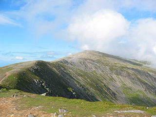
Carnedd Llewelyn, also spelled Carnedd Llywelyn, is a mountain massif in the Carneddau range in Snowdonia, north-west Wales. It is the highest point of the Carneddau and the second highest peak by relative height in Wales, 49th in the British Isles and lies on the border between Gwynedd and Conwy.

Moel Hebog is a mountain in Snowdonia, north Wales which dominates the view west from the village of Beddgelert. It gives name to a whole range of peaks in the north-western corner of Snowdonia, which include the Nantlle Ridge and Mynydd Mawr.
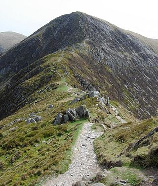
Carnedd Dafydd is a mountain peak in the Carneddau range in Snowdonia, Wales, and is the third highest peak in Wales, or the fourth if Crib y Ddysgl on the Snowdon ridge is counted. Situated south-west of Carnedd Llewelyn and north of Pen yr Ole Wen, Carnedd Dafydd is on the main ridge of the Carneddau, and on the border between Gwynedd and Conwy. The average annual temperature of the mountain is around 3–4 °C (37–39 °F).

Pen yr Ole Wen is the seventh highest mountain in Snowdonia and in Wales. It is the most southerly of the Carneddau range.
Pen yr Helgi Du is a mountain peak in the eastern part of the Carneddau in Snowdonia, North Wales.

Foel-fras is a mountain in the Carneddau range, about 10 km east of Bethesda in North Wales. It lies on the border between the counties of Gwynedd and Conwy. With a summit elevation of 944 metres, it is officially the eleventh-highest summit in Wales. Foel-fras is located at the northern end of the main ridge of the Carneddau, between Drum to the north and Foel Grach to the south with the subsidiary summit of Garnedd Uchaf between it and Foel Grach. Due south and 400 m below lies the reservoir of Llyn Dulyn, while the smaller reservoir of Llyn Anafon lies to the north.

Pen Llithrig y Wrach is a mountain peak in Snowdonia, North Wales. It is one of the four Marilyns that make up the Carneddau range. To the east is Creigiau Gleision, another Marilyn, while to the west are Pen yr Helgi Du and Carnedd Llewelyn. Craig Eigiau and Llyn Eigiau can be seen to the north, while Gallt yr Ogof, Glyder Fach and Tryfan can be viewed to the south.
Yr Elen is a mountain in the Carneddau range in Snowdonia, Wales. It is the ninth highest mountain in Snowdonia. The average annual temperature of the peak is around 4 °C (39 °F). It lies on a short ridge running north-northwest off the main northeast-to-southwest ridge of the Carneddau, just over one kilometre from Carnedd Llewelyn.

Carnedd Gwenllian, previously known as Carnedd Uchaf until 2009, is a minor summit of the Carneddau range in Snowdonia, Wales, and included in the Welsh 3000s. From the summit, distant views to the north can extend as far as Ireland and the Isle of Man, and to the South as far as the Berwyn Ranges.

Bwlch-y-Ddeufaen is a mountain pass in Conwy county borough, north Wales, traversable only on foot or horseback, following the former Roman road from Caerhun (Canovium) to Caernarfon (Segontium). The route may be followed by road to Rowen or to Llanbedr-y-Cennin and from either, the way, through a mountain gate, is a clearly marked green path to Abergwyngregyn. The route lies between the peaks of Tal y Fan and Drum, in the Carneddau range in north Snowdonia. The distance from Rowen to Abergwyngregyn is about nine miles of mostly high mountain footpath. Near the Abergwyngregyn end, the route forms part of the North Wales Path.
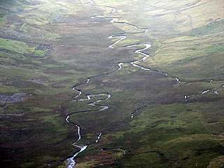
Afon Eigiau is a small river in the Carneddau mountains in Snowdonia, in north-west Wales, which flows down Cwm Eigiau and into Llyn Eigiau.

Pen y Castell is a summit in the Carneddau mountains in north Wales. It tops the east ridge of Drum (Wales). The summit consists of rocky outcrops amid a small boggy plateau. Views of the higher Carneddau ridge to the west, Craig Eigiau to the south, Tal y Fan to the north and the Conwy valley to the east can be seen.

Carnedd y Ddelw is a summit in the Carneddau mountains in north Wales, north-east of Foel-fras. It is the Nuttall top of Drum (Wales). Its eastern slopes are drained by the Afon Tafolog, a tributary of Afon Roe that flows through the village of Rowen before joining the River Conwy. It is also the final top on Carnedd Llewelyn's long northern spur. To the north-west is Tal y Fan, the most northerly 2000 foot tall mountain in the Carneddau and Wales. The summit has two large shelter cairns, hollowed out from a large Bronze Age burial cairn.

Y Drosgl is a summit of the Carneddau range in Snowdonia, Wales, and forms a part of the western Carneddau, also known as the Berau, meaning 'stacks' or 'ricks'. It lies on a ridge heading west from Carnedd Gwenllian and Bera Mawr towards Bethesda. A large ancient burial cairn, dating from the Bronze Age, adorns the summit, from where good views of Cwm Caseg and the Menai can be seen.

Carnedd y Filiast is a mountain in Snowdonia, Wales, forming part of the Glyderau. It, along with its top Y Fronllwyd, forms the most northerly summit in the Glyderau. The average annual temperature on Carnedd y Filiast is estimated to be around 4 Celsius.

Mynydd Perfedd is a mountain in Snowdonia, Wales, forming part of the Glyderau. The summit has a shelter cairn, offering good views of Foel-goch's north-eastern face, and the Carneddau.

Carnedd y Filiast is a mountain near Cerrigydrudion on the border of the Snowdonia National Park, North Wales and is 669 metres (2,195 ft) high.

Y Fronllwyd, also known as Carnedd y Filiast North Top, is a top of Carnedd y Filiast in Snowdonia, Wales forming part of the Glyderau. It is the northern end of the Glyder mountain range. The summit has good views of Bethesda, the Penrhyn Quarry, the Carneddau, Elidir Fawr and the Menai Strait. The summit was included on the original Nuttall's list, subsequently deleted and then re-included after detailed re-surveying.

Cadair Ifan Goch is a crag located above the Conwy Valley in North Wales in the community of Llanddoged and Maenan, and owned by the National Trust. The views extend across the whole of the valley to the Carneddau mountains, and even as far south as the Arenig mountains. The summit of the hill, a bit further up from the crag, reaches 207 metres (679 ft) above sea level.

