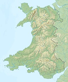
Penmaenmawr is a town and community in Conwy County Borough, Wales, which was formerly in the parish of Dwygyfylchi and the traditional county of Caernarfonshire. It is on the North Wales coast between Conwy and Llanfairfechan and was an important quarrying town, though quarrying is no longer a major employer. The population of the community was 4,353 in 2011, including Dwygyfylchi and Capelulo. The town itself having a population of 2,868 (2011).

The River Conwy is a river in north Wales. From its source to its discharge in Conwy Bay it is 55 kilometres (34 mi) long and drains an area of 678 square km. "Conwy" was formerly anglicised as "Conway."

The River Dwyryd, is a river in Gwynedd, Wales which flows principally westwards; draining to the sea into Tremadog Bay, south of Porthmadog.

Foel-fras is a mountain in the Carneddau range, about 10 km east of Bethesda in North Wales. It lies on the border between the counties of Gwynedd and Conwy. With a summit elevation of 944 metres, it is officially the eleventh-highest summit in Wales. Foel-fras is located at the northern end of the main ridge of the Carneddau, between Drum to the north and Foel Grach to the south with the subsidiary summit of Garnedd Uchaf between it and Foel Grach. Due south and 400 m below lies the reservoir of Llyn Dulyn, while the smaller reservoir of Llyn Anafon lies to the north.

The Afon Lledr is a river in north-west Wales and the second major tributary of the River Conwy. It is about 10 miles or 16 km long, and flows in a generally easterly direction.

Caerhun is a scattered rural community, and former civil parish, on the west bank of the River Conwy. It lies to the south of Henryd and the north of Dolgarrog, in Conwy County Borough, Wales, and includes several small villages and hamlets including Llanbedr-y-cennin, Rowen, Tal-y-bont and Ty'n-y-groes. It was formerly in the historic county of Caernarvonshire. At the 2001 census, it had a population of 1,200, increasing to 1,292 at the 2011 census. It includes a large part of the Carneddau range including the lakes of Llyn Eigiau, Llyn Dulyn and Llyn Melynllyn.

Bwlch-y-Ddeufaen is a mountain pass in Conwy county borough, north Wales, traversable only on foot or horseback, following the former Roman road from Caerhun (Canovium) to Caernarfon (Segontium). The route may be followed by road to Rowen or to Llanbedr-y-Cennin and from either, the way, through a mountain gate, is a clearly marked green path to Abergwyngregyn. The route lies between the peaks of Tal y Fan and Drum, in the Carneddau range in north Snowdonia. The distance from Rowen to Abergwyngregyn is about nine miles of mostly high mountain footpath. Near the Abergwyngregyn end, the route forms part of the North Wales Path.
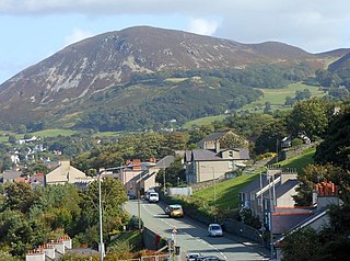
Llyn Eigiau is a lake on the edge of the Carneddau range of mountains in Snowdonia, Conwy, Wales. The name Eigiau is thought to refer to the shoals of fish which once lived here. Early maps refer to it as Llynyga. It is thought that a small number of Arctic char exist in the lake after they were transferred here from Llyn Peris, and certainly it is one of the few lakes in Wales to have its own natural brown trout. The lake is surrounded by mountains including Pen Llithrig y Wrach.
Afon Ddu is the name of several rivers in Snowdonia in north-west Wales:

Tal-y-Bont is a small village in Conwy County Borough, Wales and lies in the Conwy Valley, west of the River Conwy, on the B5106 road, 6 mi (9.7 km) from the town of Conwy to the north, and six miles from Llanrwst to the south, and in the community of Caerhun. It lies adjacent to the village of Dolgarrog to the south, and below the small settlement of Llanbedr-y-Cennin to the west. The population is around 400.

Rowen is a village on the western slopes of the Conwy valley in the parish of Caerhun and the former County of Caernarfonshire in Wales. It lies off the B5106 road, between Tal y Bont and the Groes Inn. Buildings of Gwynedd 2009 refers to the River Roe probably following the Roman route from Caerhun to Abergwyngregyn. Rowen has won tidiest village awards several times.

Drum is a summit in the Carneddau mountains in northern Wales, 2 km north-east of Foel-fras. It is 771 m (2,526 ft) high. It is also known as Carnedd Penyborth-Goch.
The Afon Tafolog is a small river in Snowdonia in north-west Wales. It is fed by a number of streams which drain the eastern slopes of Drum, a mountain in the Carneddau range.

Carnedd y Ddelw is a summit in the Carneddau mountains in north Wales, north-east of Foel-fras. It is the Nuttall top of Drum (Wales). Its eastern slopes are drained by the Afon Tafolog, a tributary of Afon Roe that flows through the village of Rowen before joining the River Conwy. It is also the final top on Carnedd Llewelyn's long northern spur. To the north-west is Tal y Fan, the most northerly 2000 foot tall mountain in the Carneddau and Wales. The summit has two large shelter cairns, hollowed out from a large Bronze Age burial cairn.

Fan Nedd is a mountain in the Fforest Fawr area of the Brecon Beacons National Park in Wales. In common with the rest of the Fforest Fawr uplands it is within the county of Powys.

The Afon Llynfi is a short river in the county of Powys, south Wales. A tributary of the River Wye, it runs approximately south to north just to the west of the Black Mountains and partly within the Brecon Beacons National Park.

Dwygyfylchi is a village in Conwy County Borough, Wales. It is part of the community of Penmaenmawr which has a population of 4,353. The electoral ward of Capelulo which includes Dwygyfylchi had a population of 1,485 in 2011. It forms part of the historic county of Caernarfonshire.

Afon Merddwr is a river in the south of the county of Conwy, Wales. It is a tributary of the River Conwy and joins it near Pentrefoelas. It is about 10 km long. "Merddwr" is Welsh for backwater or stagnant water, suggesting that it was named for its current or water quality.

Sindphana is a minor tributary of Godavari river that originates around the Chincholi hill in Patoda Taluka, Beed District, Maharashtra, in India. Crossing west to east its drainage basin covers nearly 80% of Beed District, making it the most important river within the district. The Majalgaon Dam, constructed across the river, irrigates 93885 hectares of land in Beed, Parbhani & Nanded districts.
Caer Bach is a Welsh hillfort of indeterminate age, on a rounded hillock situated near the village of Rowen; in Conwy County, North Wales. Its name in English translates as 'Small Fort'; or alternatively 'Little Fortress'. It is situated on the Eastern slopes of Tal-y-Fan, an outlying peak of the Carneddau mountain range in northeast Snowdonia; at an altitude of approximately 413 metres. Little information is known about the history of the fort, as to date, the site has undergone minimal investigation. The fort is classed as a scheduled ancient monument and is of national importance for its potential to enhance our knowledge of prehistoric settlement. It is said to retain significant archaeological potential, with a strong probability of the presence of associated archaeological features and deposits.