Gwydir Forest

Last updated

Gwydir Forest lies in an elevated position, affording views towards the Glyderau and Carneddau ranges View from Gwydir Forest.jpg
Gwydir Forest lies in an elevated position, affording views towards the Glyderau and Carneddau ranges
Aerial vieo of Gwydir Forest reservoirs, including: Llyn Cyfty, Llyn Sarnau, Llyn Goddionduon and Llyn Tynymynydd

Gwydir Forest, also spelled Gwydyr, is located in Conwy county borough and the Snowdonia National Park in Wales. It takes its name from the ancient Gwydir Estate, established by the John Wynn family of Gwydir Castle, which owned this area.

Contents

Natural Resources Wales uses the alternative spelling (i.e. Gwydyr Forest, Coedwig Gwydyr). [1] Certainly as early as 1536, Leland wrote: "Gwydir lieth two bowshots above the River Conwy. It is a pretty place."

Geography of the forest

Llyn Bodgynydd Bach, one of the many lakes in the forest Cors Bodgynydd Reservoir - geograph.org.uk - 221635.jpg
Llyn Bodgynydd Bach, one of the many lakes in the forest

The forest broadly encircles the village of Betws-y-Coed, and much of its midsection lies within the parish. It reaches northwards to the village of Trefriw, and southwards to the village of Penmachno. It covers an area of over 72.5 square kilometres (28.0 sq mi), including 49 square kilometres (19 sq mi) of productive woodland.

Certainly there would have been a certain amount of natural tree growth on these hills thousands of years ago. More recently, records from the 18th century refer to the rafting of timber down the River Conwy. In the 19th century use was made of the quay at Trefriw for the shipment of timber to the coast. In 1778, referring to Carreg-y-Gwalch, just above Gwydir Uchaf, Thomas Pennant was told that "the noblest oaks in all Wales grew on this rock within living memory."

The forest occupies an undulating plateau, reaching to between 700 and 1,000 feet (210 and 300 m) above sea level, which is divided by the valleys of the rivers Llugwy, Lledr, and Machno, all of which are tributaries of the River Conwy. Despite being a forest, much of it is not dark and enclosed, and it offers fine views over these valleys, with further views to the mountains of the Glyderau, the Carneddau and the Snowdon massif itself.

The forested areas occupy the steep slopes and poorer soils of the plateau, the best of the soil being in the agricultural valley bottoms. Rainfall in the forest varies from under 50 inches (1,300 mm) to over 80 inches (2,000 mm) p.a.

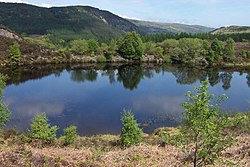
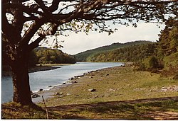
The forest is home to numerous lakes, all of which are reachable by footpaths, and nearly all of which were created to serve the mines of the Forest. In order of size, these include:

Llyn Parc, with the water at a lower level than normal Llyn Y Parc - geograph.org.uk - 74854.jpg
Llyn Parc, with the water at a lower level than normal

There are also a number of smaller, unnamed lakes.

Moel Siabod from Gwydir Forest Moel siabod from gwidir forest.jpg
Moel Siabod from Gwydir Forest

Forestry operations

Following the Forestry Act of 1919, Gwydir Forest was established by the Forestry Commission in 1921, after much of the land was acquired from Lord Ancaster, whose family had inherited the Wynn estate. The First World War had highlighted a shortage in wood production, and left the area with little natural woodland. Many of the early planters and forestry workers had no experience of forestry, being formerly employed in the forest's mines, and many anecdotes from this era can be found in the book Tales from the Gwydyr Woods. Millions of seedlings were grown in the Diosgydd nursery, and the first areas planted were those that previously had some coverage. Most of the original plantations have now been felled and replanted as part of the forestry cycle.

The majority of the forest is conifer (Sitka spruce, Douglas fir, Japanese larch, Norway spruce and Scots pine), relatively suited to the area's poor, shallow soils, but recent years have seen the increased planting of native broadleaf species such as Welsh Oak, beech and ash. This has largely been done for aesthetic reasons, i.e. to produce variety and to reduce the hard lines produced by conifers. However, commercial reasons will always dictate the need for faster-growing conifers. These have a plant-harvest cycle of between 20 and 40 years (depending on type), whereas oak requires the best part of a century.

The forest still gives direct employment to 75 people, and creates local work for many others. It is estimated that the forest is growing at a rate of 125 tons a day, and is naturally being harvested at much the same rate. At times rights of way in the forest may be closed or restricted where forestry work is being undertaken. Further information about the forest and its operations can be obtained by telephoning the Forest Office at Gwydir Uchaf (01492 640578). This property was built by Sir John Wynn in 1604.

Tourism

The land owned by Natural Resources Wales in Snowdonia National Park amounts to just over 12%, and of the four forest areas, the Gwydir Forest is probably the most popular based on visitor numbers. In 1937 Gwydir was designated a National Forest Park, and since 1993 the heartland of the forest has been accorded the special status of Forest Park. Promotion as an attraction has been an integral part of this designation.

The forest is very accessible by wide tracks, old miners' paths, and long-established forest walks, a number of which follow waymarked routes. This popularity has further increased in recent years after the construction of the Marin Trail (named after the mountain bike manufacturer), a competition-standard mountain bike route, which is approximately 28 kilometres (17 mi) long with 860 metres (2,820 ft) of climbing in all. [2] [3]

Whilst the forest has to be accessible to forest workers' vehicles (there are over 100 miles (160 km) of roads and tracks in the forest), it is not open to private vehicles except on designated Open Days. However, there are a number of forest car parks and most of these have picnic sites. The forest was used as a special stage in the 2013 Wales Rally GB.

The former mines

The remains of Hafna mine and mill Hafna Mine and Mill - geograph.org.uk - 121380.jpg
The remains of Hafna mine and mill
The chimney of the former Llanrwst mine Llanrwst Lead Mine Chimney - geograph.org.uk - 74883.jpg
The chimney of the former Llanrwst mine

Today the forest is dotted with the remains of former metal mines: old engine houses, waste tips, reservoirs, and the surface remains of the pits themselves. This, however, is nothing compared to the labyrinth of tunnels below the surface, which run to scores of miles in length. Predominantly lead and zinc were mined, and the heyday of metal mining in the forest was between 1850 and 1919, although mining on a small scale began in the early 17th century. Indeed, whilst evidence is difficult to find following centuries of subsequent mining work, it is more than likely that a certain amount of shallow mining was undertaken by the Romans—the Roman road of Sarn Helen passed through the forest.

The principal mines were those of:

These lie in the central part of the forest around the area known as Nant Bwlch-yr-haearn.

Parc Mine was the largest and most successful of these mines. It opened in 1855 as the Gwydyr Park Consols and was worked intermittently up to the 1940s. By World War II it was the only mine to be still working. It reopened in 1950, and it produced more lead and zinc ore between 1953 and 57 than the whole of the Llanrwst area in the century from 1848. Despite some subsequent modernisation it closed down in c.1960. [4]

The first four of the mines listed above have been linked by the "Miners Trail", a circular route marked with information boards. Their remains can also easily be seen from the unclassified road that runs from Gwydir Castle (on the B5106 road) via Nant Bwlch-yr-haearn to the Ugly House on the A5.

Mention has already been made of the numerous lakes in the forest, and indeed in this central area they were all, almost without exception, created or enlarged to provide reservoirs for the mine workings. In most cases water was run from these via leats, which turned water-wheels to power machinery on site.

On acquisition of the land by the then Forestry Commission, efforts were made to make former mine workings safe, and before increased public access further extensive works were carried out by the National Park Authority, with funding from the Welsh Development Agency and support from the Conservation Council (now the Countryside Council for Wales, the Welsh Mines Society, and Gwynedd Archaeological Trust. Given the opportunities that the wealth of tunnels below the mines offers, it is hoped that future identification of safe areas will allow the re-opening of some areas for limited access.

Much has been written about the mines, most notably a series of 7 books called Mines of the Gwydyr Forest.

Rare plants and animals

A capped former mine shaft. These are now often a home to bats. Mineshaft near Bwlch yr Haiarn - geograph.org.uk - 222337.jpg
A capped former mine shaft. These are now often a home to bats.

The piles of rock waste on the former mine sites have proved to be ideal breeding grounds for rare plants, and have resulted in the designation of part of the forest as a Site of Special Scientific Interest (SSSI). This very specialised group of plants are known as metallophytes, being found only around old metal workings. They are able to extract minerals from the rock that would kill other species. Principal species found on the Gwydir mine sites are pennycress and forked spleenwort.

The capping of the mine shafts for safety reasons has resulted in an ideal environment for bats, and the designation of a Special Area of Conservation (SAC). In February 2001 a lesser horseshoe bat (Rhinolophus hipposideros) was found hibernating in a disused mine in the forest, the furthest north in the UK that this species had been found. The bat had been ringed as a juvenile in 1999 in the Forest of Dean. [5]

Despite a lack of photographic evidence, there have been over 100 reported sightings of pine martens in north Wales in the last decade, and pine marten DNA was recovered from a dropping found in Gwydir Forest in 1996.

See also

Notes

  1. "Origin of name Gwydir". Archived from the original on 15 April 2008. Retrieved 7 February 2006.
  2. Review of Marin Trail
  3. Map of Marin Trail Archived 2006-07-21 at the Wayback Machine
  4. Parc Mine (Gwydyr Park Consols), Llanrwst, Gwydyr Forest area, Conwy (Gwynedd; Caernarvonshire), Wales, UK
  5. Joint Nature Conservation Committee site

Related Research Articles

<span class="mw-page-title-main">Snowdonia</span> Mountainous region and national park in north Wales

Snowdonia or Eryri is a mountainous region in northwestern Wales. The names are also used for the national park, which covers a larger area.

<span class="mw-page-title-main">Conwy County Borough</span> County borough in Wales

Conwy County Borough is a county borough in the north of Wales. It borders Gwynedd to the west and south and Denbighshire to the east. The largest settlement is Colwyn Bay, and Conwy is the administrative centre.

<span class="mw-page-title-main">Llanrwst</span> Welsh market town

Llanrwst is a market town and community on the A470 road and the River Conwy, in Conwy County Borough, Wales, and the historic county of Denbighshire. It developed round the wool trade and became known also for the making of harps and clocks. Today, less than one mile from the edge of Snowdonia, its main pursuit is tourism. Notable buildings include almshouses, two 17th-century chapels, and the Parish Church of St Grwst, which holds a stone coffin of Llywelyn the Great. The 2011 census gave it a population of 3,323.

<span class="mw-page-title-main">Trefriw</span> Human settlement in Wales

Trefriw is a village and community in Conwy County Borough, Wales. It lies on the river Crafnant a few miles south of the site of the Roman fort of Canovium, sited at Caerhun. At the last three censuses, the population of the community has been recorded as 842 in 1999, 915 in 2001, and 783 in 2011.

<span class="mw-page-title-main">River Conwy</span> River in north Wales

The River Conwy is a river in northern Wales. From its source to its discharge in Conwy Bay it is 55 kilometres (34 mi) long and drains an area of 678 square km. "Conwy" was formerly anglicised as "Conway."

<span class="mw-page-title-main">Caerdroia</span>

A caerdroia is a Welsh turf maze, usually in the sevenfold Cretan labyrinth design. They were created by shepherds on hilltops and were apparently the setting for ritual dances, the nature of which has been lost. At the centre of each caerdroia was a small hillock—in Welsh, twmpath. A gathering for folk dancing in Wales is still called a twmpath dawns. It is a typical labyrinth of Welsh but there is a specimen in Italy to Petrella Tifernina discovered by the historian Mario Ziccardi. This specimen is the only one in the Mediterranean area for now.

<span class="mw-page-title-main">Llanrhychwyn</span> Hamlet in Wales

Llanrhychwyn is a hamlet in Conwy county borough, Wales. It lies in the Conwy valley, less than a mile south of Trefriw, and a mile north-west of Llanrwst. Today neighbouring Trefriw is a village with a population of around 600, but in the time of Llywelyn Fawr, and up to the early 19th century, Llanrhychwyn was larger than Trefriw, which consisted simply of "a few houses here and there". Indeed, even today both Trefriw and Llanrhychwyn lie within the parish of Llanrhychwyn. The area around Llanrhychwyn had a population of only 178 in 2011.

<span class="mw-page-title-main">Llyn Crafnant</span> Natural lake in North Wales

Llyn Crafnant is a lake that lies in a valley in Wales where the northern edge of the Gwydir Forest meets the lower slopes of the Carneddau mountains and, more specifically, the ridge of Cefn Cyfarwydd. The head of the valley offers a profile of crags which are silhouetted at sunset. The Forest Park guide (2002) states that "the is one of the most breathtaking views in all Snowdonia". The summits include Crimpiau 475 metres, and Craig Wen 548 metres which provide views to Moel Siabod and the Ogwen Valley, and Snowdon. Further up is Creigiau Gleision. At 63 acres (250,000 m2) it is the best part of a mile long, although it was clearly once much longer - its southern end shows the evidence of centuries of silting. Jehu's survey (see references) recorded a maximum depth of 71 ft (22 m).

<span class="mw-page-title-main">Llyn Geirionydd</span> Lake in Snowdonia, Wales

Llyn Geirionydd lies in a valley in northern Wales where the northern edge of the Gwydyr Forest meets the lower slopes of the Carneddau mountains. The lake is almost a mile long and covers an area of 45 acres (180,000 m2), but is never any deeper than 50 ft (15 m) according to Jehu's survey. The lake can be reached by car from Trefriw or Llanrwst in the Conwy valley, the lane passing through the hamlet of Llanrhychwyn, or from the road through the Gwydir Forest. Access is not particularly easy by either route, but this has not stopped the lake being the only one designated in Snowdonia to permit power boats and water skiing. Many visitors also walk to the lake from the village of Trefriw or from the neighbouring lake of Llyn Crafnant, which runs parallel to it, but a mile distant, the two being separated by Mynydd Deulyn, “mountain of the two lakes”.

<span class="mw-page-title-main">Dolgarrog</span> Village and community in Conwy County Borough, Wales

Dolgarrog is a village and community in Conwy County Borough, in Wales, situated between Llanrwst and Conwy, very close to the Conwy River. The village is well known for its industrial history since the 18th century and the Eigiau dam disaster, which occurred in 1925. The population was 414 at the 2001 Census, increasing to 446 at the 2011 Census. The community extends up to, and includes part of, Llyn Cowlyd in the Carneddau.

<span class="mw-page-title-main">Afon Crafnant</span> Tributary of the River Conwy , which is the main river of the Conwy valley in north-west Wales

<span class="mw-page-title-main">River Geirionydd</span> River in Wales

<span class="mw-page-title-main">Llyn Bodgynydd</span>

Llyn Bodgynydd is a lake in the Gwydir Forest in North Wales. It covers an area of some 14 acres (57,000 m2), and lies at a height of 822 feet (251 m) a.s.l.

<span class="mw-page-title-main">Llyn Parc</span>

Llyn Park is a lake in the Gwydir Forest in North Wales.

<span class="mw-page-title-main">Cefn Cyfarwydd</span> Hill in Conwy County Borough, Wales

Cefn Cyfarwydd is a ridge in Conwy county borough, north Wales. It is located above the village of Trefriw on the western side of the Conwy valley, and dramatically separates Cwm Cowlyd and the rugged mountains of the Carneddau from the greener, lusher Conwy valley.

<span class="mw-page-title-main">Grey Mare's Tail, Conwy</span> Waterfall in Snowdonia National Park, Wales

The Grey Mare's Tail is a waterfall on the very edge of the Snowdonia National Park near Gwydir Castle in the county of Conwy, north Wales. It lies just off the B5106 road between the town of Llanrwst and the large village of Trefriw. The Welsh name, Rhaeadr y Parc Mawr, derives from the fact that the falls are fed by a large stream that has its source in the Gwydir Forest, and flows through the old Parc Mine, about a mile to the southeast. The name 'Grey Mare's Tail' was given to it by Lady Willoughby of Gwydir Castle, possibly "in compliment to Lord Byron and the Staubbach"

<span class="mw-page-title-main">St Grwst's Church, Llanrwst</span> Church in Conwy, Wales

St Grwst's Church, Llanrwst, is located in Church Street, Llanrwst, Conwy, Wales. It is an active Church in Wales parish church and is part of the Aberconwy Mission Area in the archdeaconry of St Asaph, and the diocese of St Asaph. Its benefice is united with those of Llanddoged with Capel Garmon, Llansanffraid Glan Conwy, and Eglwysbach. The church is designated by Cadw as a Grade I listed building.

<span class="mw-page-title-main">Klondyke mill</span> Former ore processing mill in Wales

<span class="mw-page-title-main">North Wales Pilgrim's Way</span> Long-distance walking route in north Wales

The North Wales Pilgrim's Way is a long-distance walking route in North Wales, running from near Holywell in the east to Bardsey Island in the west. The first half of the trail takes an inland route, with the second half following the north coast of the Llŷn Peninsula. It measures 133.9 miles (215 km) in length, and was officially launched at Porth y Swnt, Aberdaron on 10 July 2014.

References

53°07′34″N3°49′41″W / 53.126°N 3.828°W / 53.126; -3.828