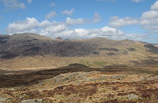
Glyderau

Last updated

Glyderau
Glyderau.jpg
The Glyderau from the north-east, dominating the Llugwy/Ogwen gap through which the A5 road passes. From left to right: Glyder Fach, Tryfan, Y Garn and Foel Goch. Llyn Ogwen is in the distance centre-right.
Highest point
PeakGlyder Fawr
Elevation 1,000.8 m (3,283 ft)
Coordinates 53°06′03″N4°01′47″W / 53.10083°N 4.02972°W / 53.10083; -4.02972
Naming
Etymology From the Welsh word "Cludair", meaning a heap of stones
Geography
CountryWales
RegionSnowdonia

The Glyderau (a Welsh plural form, also known in English as the Glyders) are a mountain group in Snowdonia, North Wales. The name derives from the highest peaks in the range, Glyder Fawr and Glyder Fach. According to Sir Ifor Williams, the word "Glyder" derives from the Welsh word "Cludair", meaning a heap of stones.

Contents

The Glyderau stretch from Mynydd Llandegai to Capel Curig, and include five of Wales' fourteen or fifteen summits over 3000 feet; these include Tryfan, considered one of the finest mountains in Wales and one of the few mountains on the British mainland requiring scrambling to reach the summit. The eastern half of the range in particular, including Glyder Fawr, Glyder Fach and Tryfan, is very popular with walkers and climbers.

Dinorwig Power Station, a hydroelectric pump-storage system, is located in a man-made cavern within Elidir Fawr. The slopes of the Glyderau also include the lake Llyn Idwal, and a number of classic climbing areas such as Rhiwiau Caws.

Geography

The Glyderau were formed in the Ordovician period about 500 million years ago as the result of two land masses moving together and causing the Snowdonia massif to rise up. Since then, erosion and the advance and retreat of glaciers during the Ice Ages has worn down the mountains to their present proportions. The underlying rock is a mixture of sedimentary and volcanic material. The last ice sheet retreated about 10,000 years ago and Cwm Idwal is a good example of a cirque formed by the ice. The main glacier flowed down the adjoining Nant Ffrancon Valley, a route now followed by the A5 road, and Cwm Idwal housed a side glacier. The ice scarred the surrounding cliffs, hollowed out the bed of Llyn Idwal and dumped rocks and other material that formed moraines at its foot. Massive boulders and shattered rocks crashed down from above to form the boulder fields and screes. [1]

The land was originally covered with native forest mostly consisting of birch and oak. This was cleared over the millennia by the Neolithic, Bronze Age and Iron Age farmers that settled here and now there is little tree cover. Groups of feral goats can still be found on the Glyderau, probably the remnants of the herds that were farmed here a thousand years ago. The large number of sheep that now graze the common land were introduced in the 18th century with the rise of the woollen industry. [1]

Access

The Glyderau present a much more rocky appearance than the smooth rounded humps of the Carneddau just to the north. The ridge between the summits of Glyder Fawr and Glyder Fach is covered with coarse grasses and heathers and strewn with boulders and slabs of rocks. The ascent to the summit of Tryfan requires scrambling rather than just walking. Tryfan, Glyder Fach and the cliffs around Cwm Idwal offer rock climbing with routes ranging from those suitable for beginners to those requiring great technical expertise. The mountains can be approached from Llyn Ogwen to the north, where there is a car park, or from Nant Peris in the Llanberis Pass where there is a park and ride service. Buses run hourly from Bangor to Llanberis and there is a less frequent service from Bethesda to Llyn Ogwen. [2]

Cwm Idwal

Llyn Idwal and the Devil's Kitchen Devil's Kitchen from Llyn Idwal - geograph.org.uk - 691764.jpg
Llyn Idwal and the Devil's Kitchen

The north-facing amphitheatre-shaped valley of Cwm Idwal with its dark cliffs has a unique flora, and some plants here are the most southerly remnants in Britain of the Arctic/Alpine flora. The Snowdon lily (Lloydia serotina) is found here, high on mountain ledges, the only place in Britain where it is found. Other Alpine species include the purple saxifrage (Saxifraga oppositifolia), tufted saxifrage (Saxifraga cespitosa), Alpine meadow rue (Thalictrum alpinum) and mountain sorrel (Oxyria digyna). Because of the scientific interest of this valley, sheep have been excluded from it to allow the native plants to flourish and it has been made into a national nature reserve. The lake itself is shallow and fringed with rushes, reeds and bottle sedge (Carex rostrata). Plants growing in the water or on the damp ground nearby include awlwort, pillwort, waterwort and spring quillwort (Isoetes echinospora). [3] Other plants growing on damp shady ledges include the Welsh poppy (Meconopsis cambrica), the wood-rush (Lazula sylvatica), water avens (Geum rivale), wood anemone (Anemone nemorosa) and goldenrod (Solidago virgaurea). Animals that live here include badgers, foxes and polecats as well as buzzards (Buteo buteo), peregrine falcons (Falco peregrinus), choughs (Pyrrhocorax pyrrhocorax), skylarks (Alauda arvensis), black grouse (Tetrao tetrix) and red grouse (Lagopus lagopus). [3]

In the cliffs above Llyn Idwal is a dark cleft in the rock known as Twll Du from which plumes of mist sometimes emanate. These were believed to be caused by ancient druids creating lightning bolts to keep the invading Romans at bay. Llyn Idwal itself was said to be named after a drowned boy, either the son of 8th century Prince Cadwalader, murdered by a rival, or the son of 12th century Prince Owain Gwynedd and killed by his uncle. The traveler Thomas Pennant, writing in the 1780s, stated that the local shepherds were in awe of the lake believing it to be "the haunt of Demons, and that no bird dare fly over its damned waters". [1]

Dinorwig Power Station

Llyn Peris Dinorwig Power Station.jpg
Llyn Peris

Deep inside the mountain of Elidir Fawr there is a power station and many miles of tunnels. Dinorwig Power Station, a pumped storage hydroelectric facility, was originally built to provide back up facilities and water storage to smooth out the peaks and troughs in demand associated with the inflexible output of nuclear power stations. When demand is low, water is pumped up the mountain and stored in Marchlyn Mawr reservoir, previously a slate quarry. The water is released to flow through turbines during times of high demand for electricity. The power is conveyed through underground cables to join the grid so as to have little visual impact on the Snowdonia National Park skyline. [4]

Management

The National Trust took over the management of the Glyderau and the Carneddau in 1951 in lieu of death duties on the Penrhyn Estate. The total area is about 7,000 hectares, half of which is common land with registered grazing rights for 45,000 sheep and 741 ponies. There are eight tenanted farms on the estate and the National Trust is responsible for the maintenance of footpaths and drystone walls, some of which date back many hundreds of years. The two mountain ranges form part of the Snowdonia National Park. [1]

Mountains in the Glyderau

This is a list of the main summits in the range, in order from west to east.

Related Research Articles

<span class="mw-page-title-main">Rhinogydd</span> Mountain range near Harlech, Wales

The Rhinogydd are a range of mountains located east of Harlech in North Wales. The name Rhinogydd derives from the names of two of the more famous peaks, Rhinog Fawr and Rhinog Fach, although the greatest elevation in the range is reached by Y Llethr, 756 m.
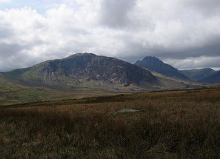
<span class="mw-page-title-main">Tryfan</span> Mountain in Wales

TryfanWelsh pronunciation: [ˈtrəvan]) is a mountain in the Ogwen Valley, Snowdonia, Wales. It forms part of the Glyderau group, and is one of the most recognisable peaks in Britain, having a classic pointed shape with rugged crags. At 917.5 metres above sea level, it is the fifteenth-highest mountain in Wales. Tryfan was voted Britain's favourite mountain by Trail magazine.

<span class="mw-page-title-main">Carneddau</span> Mountain group in Wales

The Carneddau are a group of mountains in Snowdonia, Wales. They include the largest contiguous areas of high ground in Wales and England, as well as six or seven of the highest peaks in the country—the Fifteen Peaks. The range also encloses a number of lakes such as Llyn Cowlyd and Llyn Eigiau, and the Aber Falls waterfall. It is delimited by the Irish Sea to the north, the Conwy valley to the east, and by the A5 road from Betws-y-Coed to Bethesda to the south and west. The area covers nearly 200 square kilometres (77 sq mi), about 10% of the area of Snowdonia. The area is bordered by three main roads—the A55, the A5 to the south and the A470 to the east.

<span class="mw-page-title-main">Glyder Fawr</span> Mountain in Snowdonia, Wales

Glyder Fawr is a mountain in Snowdonia, Wales, the highest peak in the Glyderau range at just over 1,000 metres, having had its height recalculated in 2010 using GPS. It is the fifth-highest mountain in Wales and has several walking and scrambling routes leading to its summit. According to Sir Ifor Williams, the word "Glyder" derives from the Welsh word "Gludair", meaning a heap of stones.

<span class="mw-page-title-main">Elidir Fawr</span> Mountain in Wales

Elidir Fawr is a mountain in Snowdonia, north Wales, the northernmost peak in the Glyderau. Its name means 'Big Elidir', named after a legendary warrior king of the 6th century also known as Eliffer Gosgorddfawr.

<span class="mw-page-title-main">Glyder Fach</span> Mountain in Wales

Glyder Fach is a mountain in Snowdonia, north-west Wales, and is the second highest of the Glyderau and the sixth highest in Wales. Routes to the summit lead from Tryfan and Bristly Ridge to the north, via Glyder Fawr from Pen-y-Pass to the south, and along the Glyder ridge to the east, towards Capel Curig. It is a popular spot for climbers.

<span class="mw-page-title-main">Ogwen Cottage</span> Mountaineering centre in Wales

Ogwen Cottage Outdoor Pursuits Centre is situated beside Llyn Ogwen, in Gwynedd, Wales. It is owned by the National Trust, who bought the property at auction in October 2014 for £450,000. It was formerly for many years part of Birmingham City Council's Outdoor Learning Service, providing outdoor education, and with links to the climbing community.

<span class="mw-page-title-main">Y Garn (Glyderau)</span> Mountain in Wales

Y Garn is a mountain in Snowdonia, North Wales, part of the Glyderau.

<span class="mw-page-title-main">Llanberis Pass</span> Mountain road in Wales

The Llanberis Pass in Snowdonia carries the main road (A4086) from the south-east to Llanberis, over Pen-y-Pass, between the mountain ranges of the Glyderau and the Snowdon massif. At the bottom of the pass is the small village of Nant Peris.

<span class="mw-page-title-main">Llyn Peris</span> Moraine dammed lake in Snowdonia, Wales

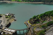
Llyn Peris is a lake in Snowdonia, Wales, approximately 1.8 km long and situated close to the villages of Llanberis and Nant Peris, and the smaller twin of Llyn Padarn. The lake was formed glacially and is an example of a moraine-dammed lake. Llyn Peris is named after Saint Peris, an early Christian saint of whom little is known. The lake is flanked on one side by the mountain Elidir Fawr and the former slate quarry of Dinorwig. Above the opposite bank are the hills of Derlwyn and Clogwyn Mawr and a rock formation known as the Lady of Snowdon, due to its resemblance to a human face. The ruins of Dolbadarn Castle are also located on a mound above the lake.

<span class="mw-page-title-main">Cwm Idwal</span> Glacial valley in Snowdonia, Wales

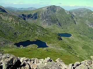
Cwm Idwal is a cirque in the Glyderau range of mountains in northern Snowdonia, the national park in the mountainous region of North Wales. Its main interest is to hill walkers and rock climbers, but it is also of interest to geologists and naturalists, given its combination of altitude, aspect (north-facing) and terrain. In a 2005 poll conducted by Radio Times, Cwm Idwal was ranked the 7th greatest natural wonder in Britain.

<span class="mw-page-title-main">Llyn Idwal</span>

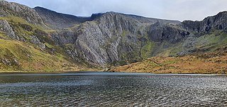
Llyn Idwal is a small lake that lies within Cwm Idwal in the Glyderau mountains of Snowdonia.

<span class="mw-page-title-main">Y Foel Goch</span>

Y Foel Goch is a mountain in Snowdonia, north-west Wales, and is a sister peak along with Gallt yr Ogof to Glyder Fach. Between Glyder Fach and its summit lies Llyn Caseg-fraith, a popular lake for photographing Tryfan and its reflection.

<span class="mw-page-title-main">Gallt yr Ogof</span> Mountain in Snowdonia, North Wales

Gallt yr Ogof is a mountain in Snowdonia, North Wales. It is a subsidiary top of Glyder Fawr, and is the most easterly point in the Glyderau mountain range, not including the hill Cefn y Capel. Gallt yr Ogof is 763 metres high.

<span class="mw-page-title-main">Foel-goch</span>

Foel-goch is a mountain in Snowdonia, north-west Wales, and forms part of the Glyderau range, in Gwynedd. It lies in between Y Garn and Mynydd Perfedd.

<span class="mw-page-title-main">Carnedd y Filiast (Glyderau)</span>

Carnedd y Filiast is a mountain in Snowdonia, Wales, forming part of the Glyderau. It, along with its top Y Fronllwyd, forms the most northerly summit in the Glyderau. The average annual temperature on Carnedd y Filiast is estimated to be around 4 Celsius.

<span class="mw-page-title-main">Mynydd Perfedd</span>

Mynydd Perfedd is a mountain in Snowdonia, Wales, forming part of the Glyderau. The summit has a shelter cairn, offering good views of Foel-goch's north-eastern face, and the Carneddau.

<span class="mw-page-title-main">Y Fronllwyd</span> Peak in Snowdonia, Wales

Y Fronllwyd, also known as Carnedd y Filiast North Top, is a top of Carnedd y Filiast in Snowdonia, Wales forming part of the Glyderau. It is the northern end of the Glyder mountain range. The summit has good views of Bethesda, the Penrhyn Quarry, the Carneddau, Elidir Fawr and the Menai Strait. The summit was included on the original Nuttall's list, subsequently deleted and then re-included after detailed re-surveying.

<span class="mw-page-title-main">Picws Du</span> Mountain (749.1m) in Carmarthenshire, Wales

Picws Du is the second highest peak of the Carmarthen Fans in the Carmarthenshire section of the Black Mountain in the west of the Brecon Beacons National Park in south Wales. The highest peak is Fan Foel immediately next along the ridge and it is a subsidiary summit of Fan Brycheiniog. Picws Du falls within Fforest Fawr Geopark and its prominent summit is marked by a large Bronze Age round barrow at a height of 2457 feet above sea level. Waun Lefrith is the other, lower summit of the Bannau Sir Gâr / Carmarthen Fans situated to the west. The peak overlooks the glacial lake of Llyn y Fan Fach in the cwm below. As the peak sits on the edge of the escarpment on a ridge which juts out into the valley below, the views from the summit are panoramic and extensive. The views to the north are especially impressive when the weather is clear, looking towards the Cambrian Mountains, Mynydd Epynt and Brecon. Swansea and the Bristol Channel can just be seen on the horizon to the south, across the gently falling dip slope. Pen y Fan and Corn Du are distinctive landmarks seen directly to the east across Fforest Fawr.

<span class="mw-page-title-main">Geology of Snowdonia National Park</span> Overview of geology in Snowdonia, Wales

The geology of Snowdonia National Park in North Wales is dominated by sedimentary and volcanic rocks from the Cambrian and Ordovician periods with intrusions of Ordovician and Silurian age. There are Silurian and Cenozoic sedimentary rocks on the park's margins. The succession was intensely faulted and folded during the Caledonian Orogeny. The region was uplifted as the North Atlantic Ocean opened during the Cenozoic. The current mountainous landscape arises from repeated glaciations during the Quaternary period.

References

  1. 1 2 3 4 Firbank, Johanna (1999). The Carneddau and Glyderau. The National Trust. ISBN   0-7078-0300-4.
  2. "Walks in the Glyderau". Walking in Snowdonia. Retrieved 2 March 2013.
  3. 1 2 "Cwm Idwal National Nature Reserve". First Nature. Retrieved 2 March 2013.
  4. Williams, Elaine (1991). Dinorwig: The Electric Mountain. National Grid.