Snowdon, or Yr Wyddfa, is a mountain in the Snowdonia region of North Wales. It has an elevation of 1,085 metres (3,560 ft) above sea level, which makes it both the highest mountain in Wales and the highest in the British Isles south of the Scottish Highlands. Snowdon is designated a national nature reserve for its rare flora and fauna, and is located within Snowdonia National Park.
The Llanberis Lake Railway is a 1 ft 11+1⁄2 in narrow gauge heritage railway that runs for 2.5 miles (4 km) along the northern shore of Llyn Padarn in north Wales in the Snowdonia National Park. The starting point is the village of Llanberis at the eastern end of the lake, with the western terminus at Pen Llyn in the Padarn Country Park. The return journey takes around 60 minutes.

The Glyderau are a mountain group in Snowdonia, North Wales. The name derives from the highest peaks in the range, Glyder Fawr and Glyder Fach. According to Sir Ifor Williams, the word "Glyder" derives from the Welsh word "Cludair", meaning a heap of stones.

Glyder Fawr is a mountain in Snowdonia, Wales, the highest peak in the Glyderau range at just over 1,000 metres. It is the fifth-highest mountain in Wales and has several walking and scrambling routes leading to its summit. According to Sir Ifor Williams, the word "Glyder" derives from the Welsh word "Gludair", meaning a heap of stones.

Pen-y-Pass is a mountain pass in Snowdonia, Gwynedd, north-west Wales. It is a popular location from which to walk up Snowdon, as three of the popular routes can be started here. Glyder Fawr, to the north, is also accessible from here.
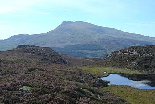
Moel Siabod is a mountain in Snowdonia, Wales, which sits isolated above the village of Dolwyddelan. At 872 metres (2,861 ft), it is the highest peak in the Moelwynion mountain range. The UK National Mountain Centre, Plas-y-Brenin, is located at the foot of Moel Siabod. From the top of the mountain, it is reputedly possible to see 13 of the 14 highest peaks in Wales on a clear day without turning one's head.
Y Garn is a mountain in Snowdonia, North Wales, part of the Glyderau.

Foel-fras is a mountain in the Carneddau range, about 10 km east of Bethesda in North Wales. It lies on the border between the counties of Gwynedd and Conwy. With a summit elevation of 944 metres, it is officially the eleventh-highest summit in Wales. Foel-fras is located at the northern end of the main ridge of the Carneddau, between Drum to the north and Foel Grach to the south with the subsidiary summit of Garnedd Uchaf between it and Foel Grach. Due south and 400 m below lies the reservoir of Llyn Dulyn, while the smaller reservoir of Llyn Anafon lies to the north.

Moel Eilio is a mountain in Snowdonia, North Wales, that is situated approximately 3 miles north-west of Snowdon itself. It has two subsidiary tops, Foel Gron and Foel Goch (Eilio). The average annual temperature of the mountain is around 6 °C (43 °F). During the winter season, some significant accumulations of snowfall is known to take place on Moel Eilio, due to its relatively flat, grassy slopes.

The Llanberis Pass in Snowdonia carries the main road (A4086) from the south-east to Llanberis, over Pen-y-Pass, between the mountain ranges of the Glyderau and the Snowdon massif. At the bottom of the pass is the small village of Nant Peris.
Dinorwig, historically spelled as Dinorwic in English, is a village located high above Llyn Padarn, near Llanberis, in Wales. The name is shared with the fort of Dinas Dinorwig, also within the community of Llanddeiniolen, on a foothill 6 kilometres (3.7 mi) from Dinorwig village and 3 kilometres (1.9 mi) from the Menai Strait and also with Port Dinorwic, the anglicised name of Y Felinheli. It lies around a mile from the larger settlement of Deiniolen.

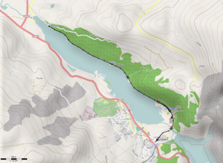
Llyn Peris is a lake in Snowdonia, Wales, approximately 1.8 km long and situated close to the villages of Llanberis and Nant Peris, and the smaller twin of Llyn Padarn. The lake was formed glacially and is an example of a moraine-dammed lake. Llyn Peris is named after Saint Peris, an early Christian saint of whom little is known. The lake is flanked on one side by the mountain Elidir Fawr and the former slate quarry of Dinorwig. Above the opposite bank are the hills of Derlwyn and Clogwyn Mawr and a rock formation known as the Lady of Snowdon, due to its resemblance to a human face. The ruins of Dolbadarn Castle are also located on a mound above the lake.

Dinorwic quarry is a large former slate quarry, now home to the Welsh National Slate Museum, located between the villages of Llanberis and Dinorwig in Wales. At its height at the start of the 20th century, it was the second largest slate quarry in Wales, after the neighbouring Penrhyn quarry near Bethesda. Dinorwic covered 700 acres (283 ha) consisting of two main quarry sections with 20 galleries in each. Extensive internal tramway systems connected the quarries using inclines to transport slate between galleries. Since its closure in 1969, the quarry has become the site of the National Slate Museum, a regular film location, and an extreme rock climbing destination.

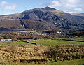
Deiniolen is a village in Gwynedd, Wales, at the foot of Elidir Fawr, in Llanddeiniolen Community. Deiniolen has views over Caernarfon and on a clear day, Holyhead Mountain and occasionally the Wicklow Mountains in Ireland, can be seen. The population of the electoral ward was 1,909 as of 2011, including nearby Dinorwig, with 81.2% of the population speaking Welsh. The community, Llanddeiniolen, has a population of 5,072 as of the 2011 census, the third-largest in Gwynedd.

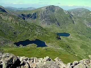
Llechog is a top of Garnedd Ugain on the Snowdon massif in Wales. It is the top of a long crest of cliffs that start in Llanberis and finishes on Garnedd Ugain. The nearby Clogwyn Station is a stop of the Snowdon mountain railway. The summit is a rocky peak sitting out from cliffs which fall steeply down to the Nant Peris valley. The viewpoint is commanding, where the full prominence of Glyder Fawr, Y Garn, Elidir Fawr and Crib Goch can be admired.

Pen Ty-Nant is a hill within the Snowdonia National Park in Gwynedd, North Wales.

Saint Padarn's Church, Llanberis is a parish church of the Church in Wales in Llanberis.
The Peris Horseshoe is an annual fell running race in Snowdonia, Wales. The race starts and finishes in Llanberis and has a distance of approximately 28 km and 2590 m of ascent. It is usually run in September. The event is organised by Eryri Harriers. It was first held in 1987, when it was organised by Arthur Clarke.

The geology of Snowdonia National Park in North Wales is dominated by sedimentary and volcanic rocks from the Cambrian and Ordovician periods with intrusions of Ordovician and Silurian age. There are Silurian and Cenozoic sedimentary rocks on the park's margins. The succession was intensely faulted and folded during the Caledonian Orogeny. The region was uplifted as the North Atlantic Ocean opened during the Cenozoic. The current mountainous landscape arises from repeated glaciations during the Quaternary period.