Glyder Fawr

Last updated

Glyder Fawr
Glyder Fawr rocks.JPG
Rocky outcrop near the summit of Glyder Fawr
Highest point
Elevation 1,001 m (3,284 ft)
Prominence 642 m (2,106 ft)
Parent peak Snowdon
Listing Marilyn, Hewitt, Welsh 3000s, Nuttall, Furth
Coordinates 53°06′03″N4°01′47″W / 53.10097°N 4.02978°W / 53.10097; -4.02978
Naming
English translationBig Lump
Language of name Welsh
PronunciationWelsh: [ˈɡlɪdɛrˈvau̯r]
Geography
Location Gwynedd / Conwy, Wales
Parent range Snowdonia
OS grid SH642579
Topo map OS Landranger 115 / Explorer OL17
Glyder Fawr viewed from the southwest, with the Nant Peris Valley Slopes of Glyder Fawr, Afon Nant Peris far below - geograph.org.uk - 585751.jpg
Glyder Fawr viewed from the southwest, with the Nant Peris Valley

Glyder Fawr is a mountain in Snowdonia, Wales, the highest peak in the Glyderau range at just over 1,000 metres. It is the fifth-highest mountain in Wales and has several walking and scrambling routes leading to its summit. According to Sir Ifor Williams, the word "Glyder" derives from the Welsh word "Gludair", meaning a heap of stones. [1]

Contents

Geography

Glyder Fawr is part of the Glyderau mountain range which lies to the northeast of the Snowdon massif, separated from that mountain by the Llanberis Pass and the Nant Peris Valley. Going from west to east, the Glyderau range consists of Elidir Fawr (924 m or 3,031 ft), Y Garn (947 m or 3,107 ft), Glyder Fawr (1,001 m or 3,284 ft), Glyder Fach (994 m or 3,261 ft) and Tryfan (918 m or 3,012 ft). To the north of the range lie the Carneddau, separated from the Glyderau by the Ogwen Valley and the Nant Ffrancon Valley. The Glyderau are separated from the surrounding mountain ranges making them stand out clearly from afar and giving them commanding views of the surrounding peaks and valleys. [2] Until late 2010, most maps showed the height of Glyder Fawr to be 999 metres (3,278 ft); however, the mountain was resurveyed with accurate GPS equipment and its height was found to be 1,000.8 m (3,283 ft 6 in). A spokesman from the Snowdonia National Park Authority was pleased by the new height, and suggested that now the mountain exceeded 1,000 m, it was sure to attract more walkers to the area. [3]

The Glyderau range was formed about five hundred million years ago, when two land masses collided, causing the Snowdonia massif to rise up. Since then, wind, water and frost, and the advance and retreat of glaciers during the ice ages have gradually worn down the mountains to their present proportions. The underlying rock is a mixture of volcanic and sedimentary material. The ice sheet of the most recent ice age retreated about ten thousand years ago leaving Cwm Idwal as an example of a cirque. The ice scarred the surrounding cliffs, hollowed out the bed of Llyn Idwal and dumped rocks and other material that formed moraines at its foot. Massive boulders and shattered rocks crashed down from above to form the boulder fields and screes visible today. [4]

Routes to the summit

The summit can be accessed from several directions: one route starts at Ogwen Cottage on the shores of Llyn Idwal and approaches the mountain from the north; another starts at Pen-y-Pass and approaches it from the south; [5] another possibility is to approach it from the east along the ridge from Glyder Fach. Although there is much shattered stone near the summit of Glyder Fach, the ridge between the two summits is fairly level and easy going. A scrambling, circuit route encompasses the three summits of Tryfan, Glyder Fach and Glyder Fawr and takes six or seven hours. [6] One of the most popular routes from Ogwen Cottage follows the shore of Llyn Idwal to the base of the famous Rhiwiau Caws (Idwal Slabs) rock climbing crag, it then makes its way out of the cwm via the steep Twll Du path, arriving at a small lake called Llyn Y Cŵn. From here a steep scree path ascends the western shoulder to the summit of Glyder Fawr. [7]

Management

The National Trust took over the management of the Glyderau and the Carneddau in 1951 in lieu of death duties on the Penrhyn Estate. The total area is about 7,000 hectares, half of which is common land with registered grazing rights for 45,000 sheep and 741 ponies. There are eight tenanted farms on the estate, and the National Trust is responsible for the maintenance of footpaths and drystone walls, some of which date back many hundreds of years. The two mountain ranges form part of the Snowdonia National Park. [4]

Related Research Articles

<span class="mw-page-title-main">Snowdonia</span> Mountainous region and national park in north Wales

Snowdonia, or Eryri, is a mountainous region and national park in North Wales. It contains all 15 mountains in Wales over 3000 feet high, including the country's highest, Snowdon, which is 1,085 metres (3,560 ft) tall. These peaks are all part of the Snowdon, Glyderau, and Carneddau ranges in the north of the region. The shorter Moelwynion and Moel Hebog ranges lie immediately to the south.

<span class="mw-page-title-main">Rhinogydd</span> Mountain range near Harlech, Wales

The Rhinogydd are a range of mountains located east of Harlech in North Wales. The name Rhinogydd derives from the names of two of the more famous peaks, Rhinog Fawr and Rhinog Fach, although the greatest elevation in the range is reached by Y Llethr, 756 m.

<span class="mw-page-title-main">Cambrian Mountains</span> Series of mountain ranges in Wales

The Cambrian Mountains are a series of mountain ranges in Wales. The term Cambrian Mountains used to apply to most of the upland of Wales, and comes from the country's Latin name Cambria. Since the 1950s, its application has become increasingly localised to the geographically homogeneous Mid Wales uplands, known in Welsh as Elenydd, which extend from Plynlimon (Pumlumon) to Radnor Forest in the east and Mynydd Mallaen to the south. This barren and sparsely populated 'wilderness' has been referred to as the Desert of Wales. The area includes the sources of the River Severn and River Wye and was unsuccessfully proposed as a national park in the 1960s and 1970s. The highest point of the range is Plynlimon, at 2,467 feet (752 m).

<span class="mw-page-title-main">Tryfan</span> Mountain in northwest Wales

Tryfan is a mountain in the Ogwen Valley, Snowdonia, Wales. It forms part of the Glyderau group, and is one of the most recognisable peaks in Britain, having a classic pointed shape with rugged crags. At 917.5 metres above sea level, it is the fifteenth-highest mountain in Wales. Tryfan was voted Britain's favourite mountain by Trail magazine.

<span class="mw-page-title-main">Glyderau</span> Mountain group in Wales

The Glyderau are a mountain group in Snowdonia, North Wales. The name derives from the highest peaks in the range, Glyder Fawr and Glyder Fach. According to Sir Ifor Williams, the word "Glyder" derives from the Welsh word "Cludair", meaning a heap of stones.

<span class="mw-page-title-main">Carneddau</span> Mountain group in Wales

The Carneddau are a group of mountains in Snowdonia, Wales. They include the largest contiguous areas of high ground in Wales and England, as well as six or seven of the highest peaks in the country—the Fifteen Peaks. The range also encloses a number of lakes such as Llyn Cowlyd and Llyn Eigiau, and the Aber Falls waterfall. It is delimited by the Irish Sea to the north, the Conwy valley to the east, and by the A5 road from Betws-y-Coed to Bethesda to the south and west. The area covers nearly 200 square kilometres (80 sq mi), about 10% of the area of Snowdonia. The area is bordered by three main roads—the A55, the A5 to the south and the A470 to the east.

<span class="mw-page-title-main">Elidir Fawr</span> Mountain in Wales

Elidir Fawr is a mountain in Snowdonia, north Wales, the northernmost peak in the Glyderau. Its name means 'Big Elidir', named after a legendary warrior king of the 6th century also known as Eliffer Gosgorddfawr.

<span class="mw-page-title-main">Glyder Fach</span> Mountain in Wales

Glyder Fach is a mountain in Snowdonia, north-west Wales, and is the second highest of the Glyderau and the sixth highest in Wales. Routes to the summit lead from Tryfan and Bristly Ridge to the north, via Glyder Fawr from Pen-y-Pass to the south, and along the Glyder ridge to the east, towards Capel Curig. It is a popular spot for climbers.

<span class="mw-page-title-main">Ogwen Cottage</span> Mountaineering centre in Wales

Ogwen Cottage Outdoor Pursuits Centre is situated beside Llyn Ogwen, in Gwynedd, Wales. It is owned by the National Trust, who bought the property at auction in October 2014 for £450,000. It was formerly for many years part of Birmingham City Council's Outdoor Learning Service, providing outdoor education, and with links to the climbing community.

<span class="mw-page-title-main">Y Garn (Glyderau)</span> Mountain in Wales

Y Garn is a mountain in Snowdonia, North Wales, part of the Glyderau.

<span class="mw-page-title-main">Pen Llithrig y Wrach</span> Mountain in Conwy County Borough, Wales

Pen Llithrig y Wrach is a mountain peak in Snowdonia, North Wales. It is one of the four Marilyns that make up the Carneddau range. To the east is Creigiau Gleision, another Marilyn, while to the west are Pen yr Helgi Du and Carnedd Llewelyn. Craig Eigiau and Llyn Eigiau can be seen to the north, while Gallt yr Ogof, Glyder Fach and Tryfan can be viewed to the south.

<span class="mw-page-title-main">Dyffryn Ogwen</span> Valley in northwest Wales

Dyffryn Ogwen, or Ogwen Valley, is a valley mostly located in the Welsh county of Gwynedd. The upper section of the valley, east of Llyn Ogwen, lies in the county of Conwy.

<span class="mw-page-title-main">Llanberis Pass</span> Mountain road in Wales

The Llanberis Pass in Snowdonia carries the main road (A4086) from the south-east to Llanberis, over Pen-y-Pass, between the mountain ranges of the Glyderau and the Snowdon massif. At the bottom of the pass is the small village of Nant Peris.

<span class="mw-page-title-main">Llyn Ogwen</span> Lake in northwestern Wales

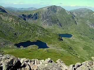
Llyn Ogwen is a ribbon lake in north-west Wales. It lies alongside the A5 road between two mountain ranges of Snowdonia, the Carneddau and the Glyderau. Somewhat unusually, the county boundary at this point is drawn so that the lake itself lies in the county of Gwynedd, but all the surrounding land lies in Conwy County Borough.

<span class="mw-page-title-main">Nant Ffrancon Pass</span> Mountain pass in Wales

The Nant Ffrancon Pass in Snowdonia, North Wales is at 312 metres (1,024 ft) at Pont Wern-gof, about one-third of a mile beyond the eastern end of Llyn Ogwen. The A5 road crosses it between Llyn Ogwen and Bethesda, Gwynedd.

<span class="mw-page-title-main">Cwm Idwal</span> Glacial valley in Snowdonia, Wales

Cwm Idwal is a cirque in the Glyderau range of mountains in northern Snowdonia, the national park in the mountainous region of North Wales. Its main interest is to hill walkers and rock climbers, but it is also of interest to geologists and naturalists, given its combination of altitude, aspect (north-facing) and terrain. In a 2005 poll conducted by Radio Times, Cwm Idwal was ranked the 7th greatest natural wonder in Britain.

<span class="mw-page-title-main">Llyn Idwal</span>

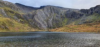
Llyn Idwal is a small lake that lies within Cwm Idwal in the Glyderau mountains of Snowdonia.

<span class="mw-page-title-main">Foel-goch</span>

Foel-goch is a mountain in Snowdonia, north-west Wales, and forms part of the Glyderau range, in Gwynedd. It lies in between Y Garn and Mynydd Perfedd.

<span class="mw-page-title-main">Carnedd y Filiast (Cerrigydrudion)</span> Mountain in Gwynedd, Wales

Carnedd y Filiast is a mountain near Cerrigydrudion on the border of the Snowdonia National Park, North Wales and is 669 metres (2,195 ft) high.

<span class="mw-page-title-main">Geology of Snowdonia National Park</span> Overview of geology in Snowdonia, Wales

The geology of Snowdonia National Park in North Wales is dominated by sedimentary and volcanic rocks from the Cambrian and Ordovician periods with intrusions of Ordovician and Silurian age. There are Silurian and Cenozoic sedimentary rocks on the park's margins. The succession was intensely faulted and folded during the Caledonian Orogeny. The region was uplifted as the North Atlantic Ocean opened during the Cenozoic. The current mountainous landscape arises from repeated glaciations during the Quaternary period.

References

  1. Nuttall, John; Nuttall, Anne (1999). The Mountains of England & Wales - Volume 1: Wales (2nd edition ed.). Milnthorpe, Cumbria: Cicerone. ISBN   1-85284-304-7.
  2. "A look at the Glyderau". Snowdon: Wales highest mountain. Gwychder y Wyddfa. 21 September 2010. Archived from the original on 25 March 2016. Retrieved 24 April 2016.
  3. "New height makes Snowdonia peak 'super mountain'". BBC News. 21 September 2010. Retrieved 24 April 2016.
  4. 1 2 Firbank, Johanna (1999). The Carneddau and Glyderau. The National Trust. ISBN   0-7078-0300-4.
  5. Williams, Alwyn. "Walk 1454 - Glyder Fawr and Glyder Fach from Pen-y-Pass". Walking Britain. Retrieved 24 April 2016.
  6. Walking Englishman. "Tryfan, Glyder Fach and Glyder Fawr" . Retrieved 24 April 2016.
  7. "The Glyderau from Llyn Idwal". Walking in Snowdonia. Retrieved 24 April 2016.