Cross Fell

Last updated

Cross Fell
Crossfell.jpg
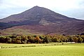
Cross Fell seen from the Eden Valley
Highest point
Elevation 893 m (2,930 ft)
Prominence 651 m (2,136 ft)
Listing Hewitt, Marilyn, Nuttall, Hardy
Coordinates 54°42′10″N2°29′14″W / 54.70278°N 2.48722°W / 54.70278; -2.48722
Geography
Location relief map United Kingdom Eden.svg
Red triangle with thick white border.svg
Cross Fell
Location in Eden, Cumbria
Cumbria UK relief location map.jpg
Red triangle with thick white border.svg
Cross Fell
Location in Cumbria, England
Location North Pennines, England
OS grid NY687343
Topo map OS Landranger 91

Cross Fell is the highest mountain in the Pennines of Northern England and the highest point in England outside the Lake District. It is located in the North Pennines Area of Outstanding Natural Beauty. It lies within the county of Cumbria and the historic county boundaries of Cumberland.

Contents

The summit, at 893 metres (2,930 ft), is a stony plateau, part of a 7+34-mile-long (12.5-kilometre) ridge running north-west to south-east, which also incorporates Little Dun Fell at 842 metres (2,762 ft) and Great Dun Fell at 848 metres (2,782 ft). The three adjoining fells form an escarpment that rises steeply above the Eden Valley on its south-western side and drops off more gently on its north-eastern side towards the South Tyne and Tees Valleys.

Cross Fell summit is crowned by a cross-shaped dry-stone shelter. [1] On a clear day there are excellent views from the summit across the Eden Valley to the mountains of the Lake District. On the northern side of Cross Fell there are also fine views across the Solway Firth to the Southern Uplands of Scotland.

The fell is prone to dense hill fog and fierce winds. A shrieking noise induced by the Helm Wind is a characteristic of the locality. [note 1] It can be an inhospitable place for much of the year. In ancient times it was known as "Fiends Fell" and believed to be the haunt of evil spirits. [3] St Augustine of Canterbury is said to have blessed the hill when he arrived here on his travels so it became known as Cross Fell in the Christian tradition, although it has been speculated[ by whom? ] that the fell became known as Cross Fell ("cross" meaning "angry") because of the evil spirits.

Local geography

The summit of Cross Fell with Great Dun Fell and its radar station in the background. The object in the centre foreground is a triangulation point Cross Fell summit.jpg
The summit of Cross Fell with Great Dun Fell and its radar station in the background. The object in the centre foreground is a triangulation point

The upper parts of Cross Fell and the adjoining fells are formed mainly from beds of mudstone, sandstone and siltstone of the Yoredale Group whilst lower ground is formed by multiple layers of the Carboniferous Limestone. [4] Where erosion-resistant beds surface, there are steep rock faces. There are also strata of shale and gritstone that surface on the fell. On the south and west facing slopes of Cross Fell the rock faces have been broken up by frost action to give a scree slope made up of large boulders. The local terrain shows obvious evidence of recent glaciation and is covered by thin soil and acidic peat.

Cross Fell, Great Dun Fell and Little Dun Fell form a block of high terrain which is all over 800 metres (2,625 ft) in elevation. This is the largest block of high ground in England and tends to retain snow-cover longer than neighbouring areas. Snow can be found in gullies on the north side of Cross Fell as late as May in most years. In some years, lying snow has been known to persist until July and fresh snowfall in June (mid-summer in the Northern Hemisphere) is common.

Precipitation on Cross Fell averages around 2,800 millimetres (110 in) per year. Local flora includes a number of rare alpine plants such as the Starry Saxifrage and a mountain Forget-me-not. [5] Cross Fell is covered by what is known as "siliceous alpine and boreal grassland". It is the southernmost outlier of this vegetation type, which is common to highlands in Scotland and Scandinavia. It is a designated Special Area of Conservation (SAC). Local farmers are required to keep free-roaming sheep off the tops of the fells in order to avoid damaging the natural flora. [6]

Cross Fell is a conspicuous feature in the landscape. It dominates the skyline on almost the entire 20-mile (32-kilometre) length of the A66 trunk road between Penrith and Stainmore. It can also be seen from many points in the Lake District, including the Helvellyn summit, and from high ground throughout Dumfriesshire and Northumberland. Most remarkably, it is claimed that it is visible in exceptional circumstances from the summit of Carnedd Llewelyn in Snowdonia (Wales) at a distance of 123 miles (198 kilometres). [7]

Notes

  1. The Helm Wind can be very strong where it is channelled down gullies in the side of the escarpment. It is experienced particularly in the villages of Milburn and Kirkland. [2]

Related Research Articles

<span class="mw-page-title-main">Pennine Way</span> Long distance footpath in England

The Pennine Way is a National Trail in England, with a small section in Scotland. The trail stretches for 268 miles (431 km) from Edale, in the northern Derbyshire Peak District, north through the Yorkshire Dales and Northumberland National Park and ends at Kirk Yetholm, just inside the Scottish border. The path runs along the Pennine hills, sometimes described as the "backbone of England". Although not the United Kingdom's longest National Trail, it is according to The Ramblers, "one of Britain's best known and toughest".

<span class="mw-page-title-main">Kinder Scout</span> Mountain in northern England, UK

Kinder Scout is a moorland plateau and National Nature Reserve in the Dark Peak of the Derbyshire Peak District in England. Part of the moor, at 636 metres (2,087 ft) above sea level, is the highest point in the Peak District, in Derbyshire and the East Midlands.

<span class="mw-page-title-main">Helvellyn</span> Mountain in the English Lake District

Helvellyn is a mountain in the English Lake District, the highest point of the Helvellyn range, a north–south line of mountains to the north of Ambleside, between the lakes of Thirlmere and Ullswater.

<span class="mw-page-title-main">North Pennines</span> Range of hills in northern England

The North Pennines is the northernmost section of the Pennine range of hills which runs north–south through northern England. It lies between Carlisle to the west and Darlington to the east. It is bounded to the north by the Tyne Valley and to the south by the Stainmore Gap.

<span class="mw-page-title-main">Carneddau</span> Mountain group in Wales

The Carneddau are a group of mountains in Snowdonia, Wales. They include the largest contiguous areas of high ground in Wales and England, as well as six or seven of the highest peaks in the country—the Fifteen Peaks. The range also encloses a number of lakes such as Llyn Cowlyd and Llyn Eigiau, and the Aber Falls waterfall. It is delimited by the Irish Sea to the north, the Conwy valley to the east, and by the A5 road from Betws-y-Coed to Bethesda to the south and west. The area covers nearly 200 square kilometres (80 sq mi), about 10% of the area of Snowdonia. The area is bordered by three main roads—the A55, the A5 to the south and the A470 to the east.

<span class="mw-page-title-main">Carnedd Llewelyn</span> Mountain in Wales

Carnedd Llewelyn, also spelled Carnedd Llywelyn, is a mountain massif in the Carneddau range in Snowdonia, north-west Wales. It is the highest point of the Carneddau and the second highest peak by relative height in Wales, 49th in the British Isles and lies on the border between Gwynedd and Conwy.

<span class="mw-page-title-main">The Cheviot</span> Highest summit in the Cheviot Hills, England

The Cheviot is an extinct volcano and the highest summit in the Cheviot Hills and in the county of Northumberland. Located in the extreme north of England, it is a 1+14-mile (2-kilometre) walk from the Scottish border and, with a height of 2,674 feet above sea-level, is located on the northernmost few miles of the Pennine Way, before the descent into Kirk Yetholm.

<span class="mw-page-title-main">Dom (mountain)</span> Mountain in the Pennine Alps, Switzerland

The Dom is a mountain of the Pennine Alps, located between Randa and Saas-Fee in the canton of Valais in Switzerland. With a height of 4,545 m (14,911 ft), it is the seventh highest summit in the Alps, overall. Based on prominence, it can be regarded as the third highest mountain in the Alps, and the second highest in Switzerland, after Monte Rosa. The Dom is the main summit of the Mischabel group, which is the highest massif lying entirely in Switzerland.

<span class="mw-page-title-main">Mickle Fell</span> Mountain in northern England

Mickle Fell is a mountain in the Pennines, the range of hills and moors running down the middle of Northern England. It has a maximum elevation of 788 m (2,585 ft). It lies slightly off the main watershed of the Pennines, about 10 miles south of Cross Fell. After Cross Fell, Mickle Fell is the highest Marilyn within the North Pennines designated Area of Outstanding Natural Beauty (AONB).

<span class="mw-page-title-main">Great Dun Fell</span> Mountain in the United Kingdom

At a height of 848 metres (2,782 ft), Great Dun Fell is the second-highest mountain in England's Pennines, lying two miles (3.2 km) south along the watershed from Cross Fell, its higher neighbour. Together with its smaller twin, Little Dun Fell, which reaches 842 m (2,762 ft), it forms a stepping-stone for the Pennine Way on its long climb up from Dufton. It lies within the historic county boundaries of Westmorland, the ceremonial county of Cumbria, and the modern unitary authority area of Westmorland & Furness.

<span class="mw-page-title-main">Pennine Bridleway</span>

The Pennine Bridleway is a National Trail in Northern England.

<span class="mw-page-title-main">Mount Feathertop</span> Mountain in Victoria, Australia

Mount Feathertop is the second-highest mountain in the Australian state of Victoria and is part of the Australian Alps and is located within the Alpine National Park. It rises to 1,922 metres (6,306 ft) and is usually covered in snow from June to September. Unlike most mountains in the Australian Alps, Mount Feathertop has steep summit slopes instead of a rounded summit dome. Snow remaining in the summit gullies until late spring gives the appearance of feathers, hence the name.

<span class="mw-page-title-main">Grisedale Pike</span> Mountain in the English Lake District, Cumbria, England

Grisedale Pike is a fell in the Lake District, Cumbria, England, situated 4+12 miles west of the town of Keswick in the north-western sector of the national park. At a height of 791 metres it is the 40th-highest Wainwright in the Lake District; it also qualifies as a Hewitt, Marilyn and Nuttall. Grisedale Pike presents a striking appearance when viewed from the east, particularly from the vicinity of Keswick. It possesses two subsidiary summits: one unnamed ; the other Hobcarton End.

<span class="mw-page-title-main">Nine Standards Rigg</span>

Nine Standards Rigg is the summit of Hartley Fell in the Pennine Hills of England. It lies near the boundary between Cumbria and North Yorkshire, a few miles south-east of Kirkby Stephen and approximately 770 yards (700 m) outside the Yorkshire Dales National Park. Nine Standards Rigg lies within the North Pennines Area of Outstanding Natural Beauty (AONB). The name is derived from a group of cairns, the Nine Standards, located near the summit. The fell is listed as Nine Standards Rigg, rather than Hartley Fell, in Alan Dawson's book The Hewitts and Marilyns of England.

<span class="mw-page-title-main">Green Hill (Lancashire)</span> Mountain in Cowan Bridge, Lancashire, United Kingdom

Green Hill is a mountain or fell in north west England. Its summit is 628 metres (2,060 ft) above sea level. It is located above Cowan Bridge, Lancashire, near Kirkby Lonsdale, Cumbria, and Ingleton, North Yorkshire. Its summit is about 4 kilometres almost due west of the summit of Whernside. It forms the watershed between the River Dee and the Leck Beck: both are tributaries of the River Lune.

<span class="mw-page-title-main">Whin Rigg</span>

Whin Rigg is a fell in the English Lake District, situated in the western segment of the national park, 22 kilometres south east of the town of Whitehaven. It reaches only a modest altitude of 535 m (1,755 ft) but is part of one of the Lake District’s most dramatic landscapes in that the rugged and impressive Wastwater Screes fall from the fells summit to Wast Water over 450 m (1,500 ft) below. The fell's name means “gorse covered ridge” and originates from the Old Norse words “Hvin” meaning gorse and “Hryggr” meaning Ridge.

<span class="mw-page-title-main">Dufton</span> Human settlement in England

Dufton is a village and civil parish in Cumbria, England. Historically part of Westmorland, it lies in the Eden Valley and below Great Dun Fell. It is mostly around 180m above sea level. At the 2011 census the parish had a population of 201, increasing to 204 at the 2011 Census

<span class="mw-page-title-main">Carnedd y Filiast (Cerrigydrudion)</span> Mountain in Gwynedd, Wales

Carnedd y Filiast is a mountain near Cerrigydrudion on the border of the Snowdonia National Park, North Wales and is 669 metres (2,195 ft) high.

<span class="mw-page-title-main">Moorhouse and Cross Fell</span>

Moorhouse and Cross Fell is a Site of Special Scientific Interest covering an extensive area of moorland in the Wear Valley district of west County Durham and the Eden district of Cumbria, England. It is contiguous with Upper Teesdale SSSI to the east and Appleby Fells SSSI to the south. The area covered extends roughly from an arc through the villages of Gamblesby, Leadgate and Garrigill southward as far as Milburn in the west and Cow Green Reservoir in the east. It includes the whole of Cross Fell, the summit of which, at 893 metres asl, is the highest point in the Pennines and in England outside the Lake District.

<span class="mw-page-title-main">High Cup Gill</span>

High Cup Gill, almost a geometrically perfect U-shaped chasm, is a valley deeply incised into the Pennine scarp to the northeast of Appleby-in-Westmorland in Cumbria and within the North Pennines AONB in northern England. It is considered to be glacial in origin, ice having over-ridden the area during successive ice ages. To its southeast is Murton Fell and Dufton Fell is to the north.

References

  1. Historic shelter restored to celebrate iconic trail’s anniversary
  2. "The Helm Wind Dufton Village Cumbria". www.dufton.org.uk. Archived from the original on 27 September 2007.
  3. North Pennines AONB Partnership article on Cross Fell Archived February 21, 2006, at the Wayback Machine
  4. "GeoIndex Onshore". British Geological Survey. Retrieved 20 October 2022.
  5. Cumbrian Wildlife: plants Archived April 30, 2006, at the Wayback Machine
  6. "SAC selection - 6150 Siliceous alpine and boreal grasslands". www.jncc.gov.uk. Joint Nature Conservation Committee. Moor House – Upper Teesdale. Archived from the original on 16 March 2006. Retrieved 10 July 2006.
  7. "Viewfinder panoramas (Carnedd Llewelyn)". viewfinderpanoramas.org. de Ferranti, Jonathan. Retrieved 14 June 2020.
Panoramas