River Tyne

Last updated • 7 min readFrom Wikipedia, The Free Encyclopedia

River Tyne
Newcastle Quayside with bridges.jpg
River Tyne Gateshead Quayside
River Tyne
Location
Country United Kingdom
Constituent country England
Physical characteristics
Source South Tyne
  location Alston Moor, Cumbria, England
2nd source North Tyne
  locationDeadwater Fell, Kielder, Northumberland, England
Mouth Tynemouth
  location
Tynemouth, North Tyneside, England
  coordinates
55°0′37″N1°25′8″W / 55.01028°N 1.41889°W / 55.01028; -1.41889
Length118 km (73 miles) [1]
Basin size2,933 km2 (1,132 square miles) [2]
Discharge 
  location Bywell [2]
  average44.6 m3/s (1,580 cu ft/s) [2]
Basin features
Tributaries 
  left River Derwent
The Gateshead Millennium Bridge for pedestrians and cyclists and the Tyne Bridge for vehicles in the background in Newcastle upon Tyne Newcastle Upon Tyne bridges.jpg
The Gateshead Millennium Bridge for pedestrians and cyclists and the Tyne Bridge for vehicles in the background in Newcastle upon Tyne
Confluence of North (right) and South Tyne (left) near Warden Watersmeet - geograph.org.uk - 1254483.jpg
Confluence of North (right) and South Tyne (left) near Warden

The River Tyne /ˈtn/ is a river in North East England. Its length (excluding tributaries) is 73 miles (118 km). [1] It is formed by the North Tyne and the South Tyne, which converge at Warden near Hexham in Northumberland at a place dubbed 'The Meeting of the Waters'.

Contents

The Tyne Rivers Trust measure the whole Tyne catchment as 2,936 km2 (1,134 square miles), containing 4,399 km (2,733 miles) of waterways. [3]

Course

North Tyne

The Ordnance Survey records 'the source of the North Tyne river' at grid reference NY 605974 [4] at Deadwater, a few tens of metres short of the Scottish border. It flows southeast through the village of Kielder before entering first Bakethin Reservoir and then Kielder Water, both set within Kielder Forest. It then passes by the village of Bellingham before the River Rede enters as a left-bank tributary at Redesmouth. It passes Hadrian's Wall near Chollerford before joining the South Tyne near Warden to the northwest of Hexham.

A stone marker shows the source of the River North Tyne Source of the River North Tyne.jpg
A stone marker shows the source of the River North Tyne

South Tyne

The South Tyne rises at Tyne Head on Alston Moor, Cumbria close to the sources of the Tees and the Wear. Initially it flows north through the North Pennines Area of Outstanding Natural Beauty (AONB), enters Northumberland downstream of Alston and turns to the east as it approaches the town of Haltwhistle. Paralleling Hadrian's Wall which lies to the north, the river continues past Redburn and Haydon Bridge to join the North Tyne at Warden. This low level east-west corridor through the Pennines is referred to as the Tyne Gap. [5]

Tyne

From the confluence of the North and South Tyne at Warden, the river flows east through Northumberland by Hexham, Corbridge and Prudhoe and enters the county of Tyne and Wear to the east of Wylam. The river subsequently forms the boundary between Newcastle upon Tyne on the north bank and the Borough of Gateshead on the south bank for 13 miles (21 km), in the course of which it flows under ten bridges. To the east of Gateshead and Newcastle, the Tyne divides Hebburn and Jarrow on the south bank from Walker and Wallsend on the north bank. The Tyne Tunnel runs under the river to link Jarrow and Wallsend. Finally the river flows between South Shields and Tynemouth into the North Sea. [2]

Geography

Thomas John Taylor (1810–1861) [6] theorised that the main course of the river anciently flowed through what is now Team Valley, its outlet into the tidal river being by a waterfall at Bill Point (in the area of Bill Quay). [7] His theory was not far from the truth, as there is evidence that prior to the last ice age, the River Wear once followed the current route of the lower River Team and merged with the Tyne at Dunston. Ice diverted the course of the Wear to its current location, flowing east the course of the Tyne) and joining the North Sea at Sunderland. [8]

The River Tyne is estimated to be around 30 million years old. [9]

Conservation

The conservation of the Tyne has been handled by various bodies over the past 500 years. Conservation bodies have included: Newcastle Trinity House, [10] and the Tyne Improvement Commission. [10] The Tyne Improvement Commission conservation lasted from 1850 until 1968. [10] The 1850–1950 era was the worst period for pollution of the river. [10] The Tyne Improvement Commission laid the foundations for what has become the modern day Port of Tyne. [11] Under the management of the Tyne Improvement Commissioners, over a period of the first 70 years the Tyne was deepened from 1.83 to 9.14 m (6 feet 0 inches to 30 feet 0 inches) and had 150 million tonnes dredged from it. [11] Inside these 70 years, the two Tyne piers were built; [11] Northumbrian, Tyne and Albert Docks were built, [11] as well as the staithes at Whitehill and Dunston. [11] This infrastructure enabled millions of tonnes of cargo to be handled by the Port by 1910. [11] The tidal river has been managed by the Port of Tyne Authority since 1968. [10] [11]

The River Tyne has a charity dedicated to protecting and enhancing its waters and surrounding areas. The Tyne Rivers Trust, established in 2004, is a community-based organisation that works to improve habitat, promote better understanding of the Tyne catchment area and build the reputation of the Tyne catchment as a place of environmental excellence. [12]

Port of Tyne

The River Tyne at Bill Quay Quiet River Tyne - geograph.org.uk - 205421.jpg
The River Tyne at Bill Quay

With its proximity to surrounding coalfields, the Tyne was a major route for the export of coal from the 13th century until the decline of the coal mining industry in North East England in the second half of the 20th century. The largest coal staithes (a structure for loading coal onto ships) were located at Dunston in Gateshead, Hebburn and Tyne Dock, South Shields. The wooden staithes at Dunston, built in 1890, have been preserved, although they were partially destroyed by fire in 2006 and then a further fire in May 2020 means that the Staithes is becoming more vulnerable to vandalism and would need extensive financing to preserve it and make it secure. [13] In 2016, Tyne Dock, South Shields was still involved with coal, importing 2 million tonnes of shipments a year. The lower reaches of the Tyne were, in the late 19th and early 20th centuries, one of the world's most important centres of shipbuilding, and there are still shipyards in South Shields and Hebburn to the south of the river. To support the shipbuilding and export industries of Tyneside, the lower reaches of the river were extensively remodelled during the second half of the 19th century, with islands (including Kings Meadow, the largest) removed and meanders in the river straightened.

Name and etymology

Nothing definite is known of the origin of the designation Tyne, nor is the river known by that name until the Saxon period: Tynemouth is recorded in Anglo-Saxon as Tinanmuðe (probably dative case). The Vedra on the Roman map of Britain may be the Tyne, or may be the River Wear. Ptolemy's Tína could be a "misplaced reference" to either this river or the Tyne in East Lothian. [14] There is a theory that *tīn was a word that meant "river" in the local Celtic language or in a language spoken in England before the Celts came: compare Tardebigge.

A supposed pre-Celtic root *tei, meaning 'to melt, to flow' has also been proposed as an etymological explanation of the Tyne and similarly named rivers, [15] as has a Brittonic derivative of Indo-European *teihx, meaning 'to be dirty' (Welsh tail, 'manure'). [15]

River crossings

LJ Ross' thriller Seven Bridges from the DCI Ryan series evolves around the Tyne bridges. [16]

Artworks and sculpture

Newcastle-upon-Tyne

River God Tyne by David Wynne at Newcastle Civic Centre Civic Centre, Newcastle upon Tyne, 7 August 2010.jpg
River God Tyne by David Wynne at Newcastle Civic Centre

The river is represented, and personified, in a sculpture unveiled in 1968 as part of the new Civic Centre (seat of Newcastle City Council). Sculpted by David Wynne, the massive bronze figure River God Tyne incorporates flowing water into its design. [17]

Salmon Trail

The Environment Agency is currently working with architects and cultural consultancy xsite, in collaboration with Commissions North, to create a travelling sculpture trail along the River Tyne.

The Tyne Salmon Trail will serve as a celebration of the river, [18] its heritage and its increasingly diverse ecosystem. Historically a major symbol in the regional identity of the North East of England, the river plays host to a plethora of different species, the number of which is growing year on year in line with the rivers improving health. The trail looks to capture the imagination of residents and tourists visiting the area – providing them with the ultimate 'fact finding' design experience, which celebrates the salmon's migratory journey in the Northeast of England.

FINS, REFLECTION and JOURNEY were the first three cubes to be launched in December 2007 from a family of ten. Each cube is inspired by the textures, changing colours, movement and journey of the salmon. With each offering a 'modern day keepsake' to take away, in the form of a designed Bluetooth message.

The other cubes will be moving along the River Tyne over one year visiting different locations from Kielder to the Mouth of the Tyne in the summer 2008 before starting their long journey back to their birthplace.

Conversation Piece

Conservation piece Little Haven beach, weebles.jpg
Created by acclaimed Spanish sculptor, Juan Muñoz in 1999. Celebrating the Tyne Salmon; [18] here with the 2008 River Tyne Bluetooth Salmon Trail Cubes, [19] are the 22 bronze life size figures that command and celebrate a superb view of South Shields Harbour and the Tyne Piers.

Bamboo Bridge

For three days, from 18 to 20 July 2008, a temporary bamboo artwork was installed over the Tyne close to the Gateshead Millennium Bridge. The Bambuco Bridge was created as part of that year's 'SummerTyne' festival.

See also

Related Research Articles

<span class="mw-page-title-main">Tyne and Wear</span> County of England

Tyne and Wear is a ceremonial county in North East England. It borders Northumberland to the north and County Durham to the south, and the largest settlement is the city of Newcastle upon Tyne.

<span class="mw-page-title-main">Gateshead</span> Town in Tyne and Wear, England

Gateshead is a town in the Gateshead Metropolitan Borough of Tyne and Wear, England. It is on the River Tyne's southern bank. The town's attractions include the twenty metre tall Angel of the North sculpture on the town's southern outskirts, The Glasshouse International Centre for Music and the Baltic Centre for Contemporary Art. The town shares the Millennium Bridge, Tyne Bridge and multiple other bridges with Newcastle upon Tyne.

<span class="mw-page-title-main">South Tyneside</span> Metropolitan borough in England

South Tyneside is a metropolitan borough in the metropolitan county of Tyne and Wear, England. It is bordered by all four other boroughs in Tyne and Wear: Gateshead to the west, Sunderland in the south, North Tyneside to the north and Newcastle upon Tyne to the north-west. The border county of Northumberland lies further north. The borough was formed on 1 April 1974 by the merger of the County Borough of South Shields with the municipal borough of Jarrow and the urban districts of Boldon and Hebburn from County Durham.

<span class="mw-page-title-main">Bill Quay</span> Human settlement in England

Bill Quay is a residential area in Gateshead, located around 4 miles (6.4 km) from Newcastle upon Tyne, 12 miles (19 km) from Sunderland, and 17 miles (27 km) from Durham. In 2011, Census data for the Gateshead Metropolitan Borough Council ward of Heworth and Pelaw recorded a total population of 9,100.

<span class="mw-page-title-main">Wylam</span> Village in Northumberland, England

Wylam is a village and civil parish in the county of Northumberland, England. It is located about 10 miles (16 km) west of Newcastle upon Tyne.

The ceremonial county of Tyne and Wear is divided into 13 parliamentary constituencies, including 2 cross-county boundary seats with Northumberland and one with Durham, of which 9 are borough constituencies and 4 county constituencies. As of the 2024 general election, all 13 are represented by the Labour Party.

<span class="mw-page-title-main">Dunston railway station</span> Railway station in Tyne and Wear, England

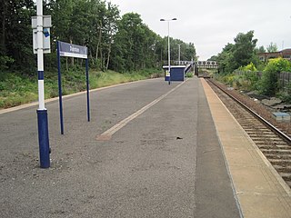
Dunston is a railway station on the Tyne Valley Line, which runs between Newcastle and Carlisle via Hexham. The station, situated 2 miles 23 chains west of Newcastle, serves the suburb of Dunston, Gateshead in Tyne and Wear, England. It is owned by Network Rail and managed by Northern Trains.

<span class="mw-page-title-main">Gateshead TMD</span> Locomotive maintenance yard in the North of England

Gateshead TMD was a railway traction maintenance depot situated in Gateshead, England. The depot code was 52A during the steam era and GD later on.

<span class="mw-page-title-main">River Tyne Police</span>

The River Tyne Police was a police force established under the Newcastle upon Tyne Port Act 1845 which patrolled the River Tyne in England between 1845 and 1968.

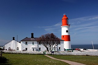
The first settlers of the South Shields area were the Brigantes, although there is no evidence they built a settlement at South Shields. The Romans built a fort there to help supply Hadrian's Wall. Many ruins still exist today. The fort was abandoned as the empire declined.

<span class="mw-page-title-main">Heworth, Tyne and Wear</span> Human settlement in England

Heworth is a residential area in Gateshead, in the county of Tyne and Wear, England. It is located around 3 miles (4.8 km) from Newcastle upon Tyne, 11 miles (18 km) from Sunderland, and 17 miles (27 km) from Durham. In 2011, Census data for the Gateshead Metropolitan Borough Council ward of Heworth and Pelaw recorded a total population of 9,100. Until 1974 it was in County Durham.

<span class="mw-page-title-main">Transport in Tyne and Wear</span> Overview of transport in Tyne and Wear

Tyne and Wear is a metropolitan area covering the cities of Newcastle upon Tyne and Sunderland, as well as North and South Tyneside, Gateshead and Washington.

<span class="mw-page-title-main">Tyne Valley line</span> Railway line in north of England

The Tyne Valley Line is a 58-mile (93 km) route, linking Newcastle upon Tyne with Hexham and Carlisle, England. The line follows the course of the River Tyne through Tyne and Wear and Northumberland. Five stations and two viaducts on the route are listed structures.

The Port of Tyne comprises the commercial docks on and around the River Tyne in Tyne and Wear in the northeast of England.

<span class="mw-page-title-main">Brandling Junction Railway</span> Former railway in England

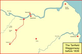
The Brandling Junction Railway was an early railway in County Durham, England. It took over the Tanfield Waggonway of 1725 that was built to bring coal from Tanfield to staiths on the River Tyne at Dunston. The Brandling Junction Railway itself opened in stages from 1839, running from Gateshead to Wearmouth and South Shields. Wearmouth was regarded at the time as the "Sunderland" terminal.

The geology of Tyne and Wear in northeast England largely consists of a suite of sedimentary rocks dating from the Carboniferous and Permian periods into which were intruded igneous dykes during the later Palaeogene Period.

<span class="mw-page-title-main">Newcastle & Carlisle Railway</span> United Kingdom legislation

The Newcastle & Carlisle Railway (N&CR) was an English railway company formed in 1825 that built a line from Newcastle upon Tyne on Britain's east coast, to Carlisle, on the west coast. The railway began operating mineral trains in 1834 between Blaydon and Hexham, and passengers were carried for the first time the following year. The rest of the line opened in stages, completing a through route between Carlisle and Gateshead, south of the River Tyne in 1837. The directors repeatedly changed their intentions for the route at the eastern end of the line, but finally a line was opened from Scotswood to a Newcastle terminal in 1839. That line was extended twice, reaching the new Newcastle Central Station in 1851.

<span class="mw-page-title-main">1973 Tyne and Wear County Council election</span> Election

The 1973 Tyne and Wear County Council election was held on 12 April 1973 as part of the first elections to the new local authorities established by the Local Government Act 1972 in England and Wales. 104 councillors were elected from 95 electoral divisions across the region's five boroughs. Each division returned either one or two county councillors each by First-past-the-post voting for a four-year term of office. The election took place ahead of the elections to the area's metropolitan borough councils, which followed on 10 May 1973.

The ceremonial county of Tyne and Wear was created under the Local Government Act 1972, which came into effect on 1 April 1974, comprising the urban areas around the mouths of the Rivers Tyne and Wear, previously parts of the historic counties of Northumberland and Durham. It returned 12 MPs to the UK Parliament from 2010 to 2024. Under the 2023 review of Westminster constituencies, coming into effect for the 2024 general election, the boundary commission proposed two cross-county boundary seats with Northumberland and one with Durham, in addition to 10 constituencies wholly within the county boundaries,.

References

  1. 1 2 Owen, Susan; et al. (2005). Rivers and the British Landscape. Carnegie. ISBN   978-1-85936-120-7.
  2. 1 2 3 4 "Environment Agency – River Tyne Salmon Action Plan Review" (PDF). Environment Agency – APEM REF EA 410230. July 2008. Archived from the original (PDF) on 28 March 2014. Retrieved 17 May 2013.
  3. "The River: Fascinating Facts about the River Tyne". Tyne Rivers Trust. Retrieved 19 August 2021.
  4. "Wheresthepath" . Retrieved 22 November 2024.
  5. "Tyne Gap and Hadrian's Wall". National Character Area profiles. Natural England. Retrieved 22 November 2024.
  6. "Thomas John Taylor". Grace's Guide to British Industrial History. Retrieved 15 May 2020.
  7. James Guthrie (1880). The river Tyne: its history and resources. Andrew Reid and Company Limited. p.  2.
  8. Land Use Consultants (2003). "Urban Landscape Study of the Tyne Gorge" (PDF). Gateshead Council. Retrieved 15 May 2020.
  9. Tyne river trust staff. "The Tyne's origins". Archived from the original on 26 March 2017. Retrieved 30 July 2017.
  10. 1 2 3 4 5 Henderson, Tony (16 January 2015), "River Tyne's story revealed in study by environmental historian", The Journal, North East England, archived from the original on 20 January 2015, retrieved 30 July 2017
  11. 1 2 3 4 5 6 7 Port of Tyne staff (30 July 2017). "Tyne Improvement Commission". portoftyne.co.uk. Port of Tyne. Archived from the original on 30 June 2017. Retrieved 30 July 2017.
  12. "Tyne Rivers Trust". Charity. Tynerivertrust.org. 2008. Retrieved 25 August 2008. The Tyne Rivers Trust is an independent charity established to assist in management and improvement of the environment in the Tyne Catchment. The Trust aims to achieve this through Actions to: Improve Habitat; Get Better Information and Promote Better Understanding; Grow the Reputation of the Tyne Catchment and the Tyne Rivers Trust nationally and internationally
  13. "Coal heritage goes up in flames". BBC. 20 November 2003. Retrieved 25 August 2008. "The staithes is a lot more than just a lump of wood in the Tyne, it is a magnificent structure and very important to the area's industrial heritage.
  14. Watson, W J (1926). The History of the Celtic Placenames of Scotland. Chippenham: Irish Academic Press. p. 51.
  15. 1 2 "The Brittonic Language in the Old North" (PDF). Scottish Place Name Society. Archived from the original (PDF) on 13 August 2017. Retrieved 20 September 2018.
  16. See the author's website, retrieved 21 January 2023.
  17. Usherwood, Beach & Morris (2000). Public Sculpture of North-East England. Liverpool University Press.
  18. 1 2 "Tyne Salmon Trail". 2008. Archived from the original on 7 August 2008. Retrieved 22 August 2008. Ten cubes inspired by the textures, changing colours, movement and journey of the salmon will migrate along the River Tyne, following the amazing journey of the salmon.
  19. Strug, Leah (21 July 2008). "Attraction's sending art lovers fishy messages". South Shields Gazette.

Sources