
North East England is one of nine official regions of England at the first level of ITL for statistical purposes. The region has three current administrative levels below the region level in the region: combined authority, unitary authority or metropolitan borough, and civil parishes. They are also multiple divisions without administrative functions; ceremonial county, emergency services, built-up areas and historic county. The largest settlements in the region are Newcastle upon Tyne, Middlesbrough, Sunderland, Gateshead, Darlington, Hartlepool and Durham.

Northumberland is a ceremonial county in North East England, bordering Scotland. It is bordered by the Scottish Borders to the north, the North Sea to the east, Tyne and Wear and County Durham to the south, and Cumbria to the west. The town of Blyth is the largest settlement.
Tyne and Wear is a ceremonial county in North East England. It borders Northumberland to the north and County Durham to the south, and the largest settlement is the city of Newcastle upon Tyne.

The River Tyne is a river in North East England. Its length is 73 miles (118 km). It is formed by the North Tyne and the South Tyne, which converge at Warden Rock near Hexham in Northumberland at a place dubbed 'The Meeting of the Waters'.

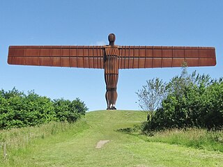
Gateshead is a town in the Gateshead Metropolitan Borough of Tyne and Wear, England. It is on the River Tyne's southern bank. The town's attractions include the twenty metre tall Angel of the North sculpture on the town's southern outskirts, The Glasshouse International Centre for Music and the Baltic Centre for Contemporary Art. The town shares the Millennium Bridge, Tyne Bridge and multiple other bridges with Newcastle upon Tyne.

Hexham is a market town and civil parish in Northumberland, England, on the south bank of the River Tyne, formed by the confluence of the North Tyne and the South Tyne at Warden nearby, and close to Hadrian's Wall. Hexham was the administrative centre for the Tynedale district from 1974 to 2009. In 2011, it had a population of 13,097.
The Metropolitan Borough of Gateshead is a metropolitan borough in the metropolitan county of Tyne and Wear, England. It includes Gateshead, Rowlands Gill, Whickham, Blaydon, Ryton, Felling, Birtley, Pelaw, Dunston and Low Fell. The borough forms part of the Tyneside conurbation, centred on Newcastle upon Tyne. At the 2021 census, the borough had a population of 196,154.

Newcastle station is a railway station in Newcastle, Tyne and Wear, England, United Kingdom. It is located on the East Coast Main Line, around 268 miles (432 km) north of London King's Cross. It is the primary national rail station serving Newcastle upon Tyne and is an interchange for local services provided by the Tyne and Wear Metro network whose Central Station is situated beneath the national rail station. It is the busiest station in Tyne & Wear, as well as the busiest in North East England.

Tyne Bridge was a parliamentary constituency in the north east of England, represented in the House of Commons of the Parliament of the United Kingdom, from 1983 until 2010. It elected one Member of Parliament (MP) by the first past the post system of election.

Dunston is a western area of the town of Gateshead on the south bank of the River Tyne, in the Metropolitan Borough of Gateshead, North East England. Dunston had a population of 18,326 at the 2011 Census.

Whickham is a village in Tyne and Wear, North East England, within the Metropolitan Borough of Gateshead. The village is on high ground overlooking the River Tyne and 5 miles (8 km) south-west of Newcastle upon Tyne.
Kingsmeadow Community Comprehensive School is a coeducational secondary school and sixth form based in Dunston, Metropolitan Borough of Gateshead. It was opened in 1990 on the site of Dunston Comprehensive School, combining the existing Saltwell Senior High, Dunston Comprehensive and Hillhead Junior High schools. The school's name came from Kings Meadow Island in the Tyne, which was dredged away in the nineteenth century to allow large ships up the river. The school has been awarded specialist Business and Enterprise College status.
Philip Turnbull is an English semi-professional footballer who plays as a midfielder for Northern Premier League Division One East club Dunston UTS.

Dunston Power Station refers to a pair of adjacent coal-fired power stations in the North East of England, now demolished. They were built on the south bank of the River Tyne, in the western outskirts of Dunston in Gateshead. The two stations were built on a site which is now occupied by the MetroCentre. The first power station built on the site was known as Dunston A Power Station, and the second, which gradually replaced it between 1933 and 1950, was known as Dunston B Power Station. The A Station was, in its time, one of the largest in the country, and as well as burning coal had early open cycle gas turbine units. The B Station was the first of a new power station design, and stood as a landmark on the Tyne for over 50 years. From the A Station's opening in 1910 until the B Station's demolition in 1986, they collectively operated from the early days of electricity generation in the United Kingdom, through the industry's nationalisation, and until a decade before its privatisation.

The Tyne Valley Line is a 58-mile (93 km) route, linking Newcastle upon Tyne with Hexham and Carlisle, England. The line follows the course of the River Tyne through Tyne and Wear and Northumberland. Five stations and two viaducts on the route are listed structures.
The Port of Tyne comprises the commercial docks on and around the River Tyne in Tyne and Wear in the northeast of England.
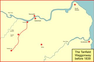
The Brandling Junction Railway was an early railway in County Durham, England. It took over the Tanfield Waggonway of 1725 that was built to bring coal from Tanfield to staiths on the River Tyne at Dunston. The Brandling Junction Railway itself opened in stages from 1839, running from Gateshead to Wearmouth and South Shields. Wearmouth was regarded at the time as the "Sunderland" terminal.

Northumbria, in modern contexts, usually refers to the region of England between the Tees and Tweed, including the historic counties of Northumberland and Durham, but it may also be taken to be synonymous with North East England. The area corresponds to the rump lands of the historical Kingdom of Northumbria, which later developed into the late medieval county of Northumberland or Comitatus Northumbriae, whose original southern boundary was the River Tees. A provincial flag of Northumbria has been registered.
King's Meadow, Kings Meadow, or Kingsmeadow, may refer to:


