
Northumberland is a ceremonial county in North East England, bordering Scotland. It is bordered by the Scottish Borders to the north, the North Sea to the east, Tyne and Wear and County Durham to the south, and Cumbria to the west. The town of Blyth is the largest settlement. Northumberland is the northernmost county in England.

The River Tyne is a river in North East England. Its length is 73 miles (118 km). It is formed by the North Tyne and the South Tyne, which converge at Warden near Hexham in Northumberland at a place dubbed 'The Meeting of the Waters'.

Sunderland is a port city in Tyne and Wear, England. It is a port at the mouth of the River Wear on the North Sea, approximately 10 miles (16 km) south-east of Newcastle upon Tyne. The built-up area had a population of 168,277 at the 2021 census, making it the second largest settlement in North East England after Newcastle. It is the administrative centre of the metropolitan borough of the same name.
North Tyneside is a metropolitan borough in the metropolitan county of Tyne and Wear, England. It forms part of the greater Tyneside conurbation. North Tyneside Council is headquartered at Cobalt Park, Wallsend.

South Shields is a coastal town in South Tyneside, Tyne and Wear, England; it is on the south bank of the mouth of the River Tyne. The town was once known in Roman times as Arbeia and as Caer Urfa by the Early Middle Ages. In 2021 it had a population of 75,337. It is the fourth largest settlement in Tyne and Wear, after Newcastle upon Tyne, Sunderland and Gateshead.

North Shields is a town in the borough of North Tyneside in Tyne and Wear, England. It is 8 miles (13 km) north-east of Newcastle upon Tyne and borders nearby Wallsend and Tynemouth.

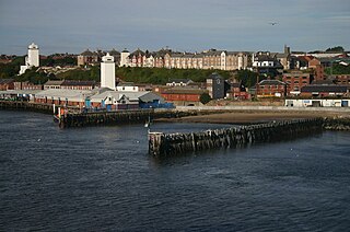
North Shields Fish Quay is a fishing port located close to the mouth of the River Tyne, in North Shields, Tyne and Wear, North East England, 8 miles (13 km) east of the city of Newcastle upon Tyne.

The Port of Liverpool is the enclosed 7.5-mile (12.1 km) dock system that runs from Brunswick Dock in Liverpool to Seaforth Dock, Seaforth, on the east side of the River Mersey and the Birkenhead Docks between Birkenhead and Wallasey on the west side of the river.

Wylam is a village and civil parish in the county of Northumberland, England. It is located about 10 miles (16 km) west of Newcastle upon Tyne.

The history of Newcastle upon Tyne dates back almost 2,000 years, during which it has been controlled by the Romans, the Angles and the Norsemen amongst others. Newcastle upon Tyne was originally known by its Roman name Pons Aelius. The name "Newcastle" has been used since the Norman Conquest of England. Due to its prime location on the River Tyne, the town developed greatly during the Middle Ages and it was to play a major role in the Industrial Revolution, being granted city status in 1882. Today, the city is a major retail, commercial and cultural centre.

Tyne Dock is a neighbourhood within the town of South Shields, Tyne and Wear, on the south bank of the River Tyne. It takes its name from the large dock on the river which was opened in 1859 by the North Eastern Railway to handle Tyneside's coal exports. At its height the trade amounted to seven million tons of coal transported via the four staiths which had been built to facilitate the process. This trade declined in the second half of the twentieth century and the bridges that carried the coal trains into the dock, the famous Tyne Dock Arches, were demolished from 1977 on. The dock itself has been progressively infilled since closure, allowing for the building of modern storage warehouses. This process concluded with the final 13 acres that were filled in as part of the project to build the second Tyne Tunnel. The Tyne Dock basin was filled with 400,000 cubic metres of sediment dredged from the Tyne.

Lemington is an area and electoral ward of Newcastle upon Tyne in North East England.

The Port of Hull is a port at the confluence of the River Hull and the Humber Estuary in Kingston upon Hull, in the East Riding of Yorkshire, England.

The Incorporated Company of Hostmen of Newcastle upon Tyne, often called the Hostmen's Company of Newcastle, is a company incorporated by royal charter of 22 March 1599/1600. Analogous to a livery company of the City of London, it still exists. It is best known to economic historians as a cartel of businessmen who formed a monopoly to control the export of coal from the River Tyne in North East England. They were so known from the medieval practice of "hosting", whereby local businessmen provided visiting merchants with accommodation and introduced them to local traders. The Hostmen acted as middlemen with whom the coal producers and those who shipped the coal to London and elsewhere were forced to deal.

The River Tyne Police was a police force established under the Newcastle upon Tyne Port Act 1845 which patrolled the River Tyne in England between 1845 and 1968.
The Keelmen of Tyne and Wear were a group of men who worked on the keels, large boats that carried the coal from the banks of both rivers to the waiting collier ships. Because of the shallowness of both rivers, it was difficult for ships of any significant draught to move up river and load with coal from the place where the coal reached the riverside. Thus the need for shallow-draught keels to transport the coal to the waiting ships. The keelmen formed a close-knit and colourful community on both rivers until their eventual demise late in the nineteenth century.

The Port of Grimsby is located on the south bank of the Humber Estuary at Grimsby in North East Lincolnshire. Sea trade out of Grimsby dates to at least the medieval period. The Grimsby Haven Company began dock development in the late 1700s, and the port was further developed from the 1840s onwards by the Manchester, Sheffield and Lincolnshire Railway (MSLR) and its successors. The port has had three main dock systems:

In 685, King Ecgfrith granted Benedict Biscop a "sunder-land". Also in 685 The Venerable Bede moved to the newly founded Jarrow monastery. He had started his monastic career at Monkwearmouth monastery and later wrote that he was "ácenned on sundorlande þæs ylcan mynstres". This can be taken as "sundorlande" or the settlement of Sunderland. Alternatively, it is possible that Sunderland was later named in honour of Bede's connections to the area by people familiar with this statement of his.

The Newcastle & Carlisle Railway (N&CR) was an English railway company formed in 1825 that built a line from Newcastle upon Tyne on Britain's east coast, to Carlisle, on the west coast. The railway began operating mineral trains in 1834 between Blaydon and Hexham, and passengers were carried for the first time the following year. The rest of the line opened in stages, completing a through route between Carlisle and Gateshead, south of the River Tyne in 1837. The directors repeatedly changed their intentions for the route at the eastern end of the line, but finally a line was opened from Scotswood to a Newcastle terminal in 1839. That line was extended twice, reaching the new Newcastle Central Station in 1851.
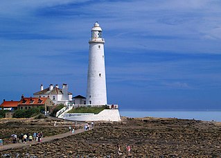
The High and Low Lights of North Shields are decommissioned leading lights in North Shields, Tyne and Wear in the United Kingdom. Two pairs of lights survive: the older pair date from 1727 and were operational until 1810; the newer pair then took over, remaining in use until 1999. All four are listed buildings. They were sometimes known as the Fish Quay High and Low Lights, or as 'Fish Quay ' and 'Dockwray Square '.
