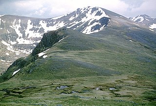
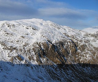
Carn Eighe is a mountain in the Northwest Highlands of Scotland. Rising to 1,183 metres (3,881 ft) above sea level, it is the highest mountain in Scotland north of the Great Glen, the twelfth-highest in the British Isles, and, in terms of relative height, it is the second-tallest mountain in the British Isles after Ben Nevis. Carn Eighe lies between Glen Affric and Loch Mullardoch, and is at the heart of a massif along with its twin peak, the 1,181-metre (3,875 ft) Mam Sodhail.
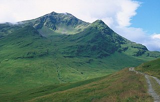
Ben Lui is a mountain in the southern Highlands of Scotland. It is a Munro with a height of 1,130 metres (3,710 ft). Ben Lui is in northeast Argyll and is the highest peak of a mountain chain that includes three other Munros. It has five well-defined ridges radiating out from the summit. Four corries lie between the ridges, including Coirre Gaothaich on the northeast side of the mountain.

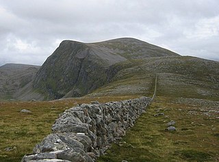
Bidean nam Bian is the highest peak in a group of mountains south of Glen Coe and north of Glen Etive in the Scottish Highlands. With a height of 1,150 metres (3,770 ft), it is a Munro and the highest point in Argyll. It is a complex mountain with many ridges and subsidiary peaks, one of which, Stob Coire Sgreamhach, is classified as a separate Munro.

Stob Coire Sgreamhach is a mountain in Lorn, south of Glen Coe in the Scottish Highlands. Its height is 1,072 metres (3,517 ft). It is part of the Bidean nam Bian massif and is often considered a subsidiary peak of Bidean, though since the 1997 revision of Munros Tables it has been classified as a separate Munro. To the northeast is the ridge of Beinn Fhada.
Beinn Dearg is a mountain in the Inverlael area of the Highlands of Scotland. It is most frequently climbed by following the River Lael up Gleann na Sguaib. Starting from near the head of Loch Broom, a path follows the glen to a bealach, which is about one kilometre north of the summit. From this bealach, the neighbouring peaks of Cona' Mheall and Meall na Ceapraichean may also be climbed. Eididh nan Clach Geala, which lies about three kilometres north of Beinn Dearg, is also added in to complete a round of four Munros.

Slioch is a mountain in the Scottish Highlands situated in Wester Ross, eight kilometres north of the village of Kinlochewe. Slioch reaches an elevation of 981 metres and towers above the southeastern end of Loch Maree to give one of the best known and most photographed sights in the Highlands. VisitScotland, the Scottish national tourist agency, has used video footage of Slioch in its television advertisements.

Mam Sodhail, or Màm Sabhail in Gaelic, sometimes anglicised "Mam Soul", is a mountain with a height of 1,181 metres (3,875 ft) in the Northwest Highlands of Scotland. Classed as a Munro, it is beside Carn Eige in the secluded country on the northern side of Glen Affric, some 30 kilometres east of Kyle of Lochalsh.

Sàileag is Scottish mountain located on the northern side of Glen Shiel, 27 kilometres south east of Kyle of Lochalsh.

Sgùrr Fhuaran is a Scottish mountain that is situated on the northern side of Glen Shiel, 23 kilometres (14 mi) east south east of Kyle of Lochalsh.
Stùc a' Chroin is a mountain in the Breadalbane region of the southern Scottish Highlands. It is a Munro, with a height of 975 metres (3,199 ft). It lies a short distance south of Ben Vorlich and east of Strathyre. The boundary between the council areas of Perth and Kinross and Stirling passes through the summit of the peak, and the town of Callander lies to the south.

Kintail is a mountainous area sitting at the head of Loch Duich in the Northwest Highlands of Scotland, located in the Highland Council area.

Beinn Achaladair is a Scottish mountain situated six kilometres north east of the hamlet of Bridge of Orchy. The mountain stands on the border of the Perth and Kinross and Argyll and Bute council areas.

Beinn a' Chroin is a mountain in the Breadalbane region of the Scottish Highlands, six kilometres south of Crianlarich. With a height of 941 metres (3,087 ft) it qualifies as a Munro.
Creag Mhòr is a mountain in the Breadalbane region of the Scottish Highlands. It is in the Forest of Mamlorn, ten kilometres northeast of Tyndrum, and is one of the remotest of the southern Highlands Creag Mhòr reaches a height of 1047 metres (3435 ft) and qualifies as a Munro and a Marilyn. It is often climbed with the neighbouring Munro of Beinn Heasgarnich; the two mountains form the high ground between Glen Lochay and Loch Lyon.

Beinn Sgritheall or Beinn an Sgrithill, also anglicized Ben Sgriol, is the highest mountain on the Glenelg peninsula in the Northwest Highlands of Scotland. It is a Munro with a height of 974 metres (3,196 ft). The main approach is via Arnisdale on the shores of Loch Hourn or via Gleann Beag to the north, with its well-known brochs. The view from the summit was described by Sir Hugh Munro, a founder member of the Scottish Mountaineering Club, as "perhaps the most beautiful I have seen in Scotland".

Meall Glas is a mountain situated in the southern highlands of Scotland. It stands on the northern border of the Loch Lomond and the Trossachs National Park, 8.5 kilometres north east of Crianlarich.

Càrn a' Gheòidh or Càrn Gheòidh is a mountain in the Mounth region of the Scottish Highlands. It lies 15 km south of the town of Braemar. Its summit stands on the border between the council areas of Perth and Kinross and Aberdeenshire.
Sgòr Gaoith is a mountain peak in the far western massif of the Cairngorms in the Scottish Highlands. It is 1,118 metres (3,668 ft) high, and is the highest point on a long north-south ridge. The ridge is separated from the Braeriach massif to the east by Gleann Eanaich and Loch Eanaich.
Glas Tulaichean is a large, complex mountain in the Mounth, Scotland. It is about 18 kilometres (11 mi) south of Braemar in Perth and Kinross. It is the highest of a group of domed hills which lie in remote land between the head of Glen Tilt and Glen Shee to the east. It is most commonly climbed from the Spittal of Glenshee via Glen Lochsie to the south.

Beinn Mhanach, also anglicized Ben Vannoch, is a mountain in the Breadalbane region of the Scottish Highlands. It is east from Bridge of Orchy, overlooking Loch Lyon to the south and Gleann Cailliche to the north. It is a Munro with a height of 953 metres (3,127 ft). The mountain has two rounded summits; the western one is called Beinn a 'Chuirn and rises to 923 metres (3,028 ft). From the West Highland Line and the A82 road, the mountain can be seen clearly 8 km north-east up the Auch Gleann. On the southern side the slopes are grassy but the more remote northern side is craggier.


