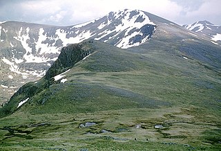
Carn Eige is a mountain in the Northwest Highlands of Scotland. Rising to 1,183 metres (3,881 ft) above sea level, it is the highest mountain in Scotland north of the Great Glen, the twelfth-highest in the British Isles, and, in terms of relative height, it is the second-tallest mountain in the British Isles after Ben Nevis. Carn Eige lies between Glen Affric and Loch Mullardoch, and is at the heart of a massif along with its twin peak, the 1,181-metre (3,875 ft) Mam Sodhail.

Drumnadrochit is a village in the Highland local government council area of Scotland, lying near the west shore of Loch Ness at the foot of Glen Urquhart. The village is close to several neighbouring settlements: the villages of Milton to the west, Kilmore to the east and Lewiston to the south. The villages act as a centre for regional tourism beside Loch Ness, as well as being a local economic hub for the nearby communities.

The Falls of Glomach, in Ross-shire, Scotland, is one of the tallest waterfalls in Britain, with a drop of 113 m (370 ft). The falls border Kintail, donated to the National Trust for Scotland in 1944 and subsequently incorporating West Affric in 1993. It is not easily reached on foot, requiring a 20 kilometre trek through remote and wild countryside.

Sgùrr nan Ceathreamhnan is a mountain in the Northwest Highlands of Scotland. It lies between Glen Affric and Glen Elchaig, some 30 kilometres east of Kyle of Lochalsh. With a height of 1,151 metres (3,776 ft) it is classed as a Munro and ranked as the third highest mountain north of the Great Glen.

Mam Sodhail or Màm Sabhail (Gaelic), sometimes anglicised "Mam Soul", is a mountain with a height of 1,181 metres (3,875 ft) in the Northwest Highlands of Scotland. Classed as a Munro, it is beside Carn Eige in the secluded country on the northern side of Glen Affric, some 30 kilometres east of Kyle of Lochalsh.

A' Chralaig is a mountain in the Northwest Highlands of Scotland, north of Loch Cluanie and south of Glen Affric. It is a Munro with a height of 1,120 metres (3,670 ft). It is the highest peak along Glen Shiel and can be easily climbed from the Cluanie Inn on the A87. The eastern slopes of the mountain, are owned by the Forestry Commission and are part of the Kintail National Scenic Area.

Ciste Dhubh is a mountain in the Scottish Highlands, between Glen Shiel and Glen Affric. With a height of 979 metres (3,212 ft), it is classed as a Munro. It is almost surrounded by glens: Fionngleann (north), An Caorann Mòr (east) and Allt Cam-bàn (west), with the Bealach a' Chòinich pass (south) linking it to the mountain of Sgùrr an Fhuarail. Its name comes from Scottish Gaelic A' Chiste Dhubh, "the black chest", possibly referring to the dark rocky summit.

Aonach Meadhoin is a Munro mountain situated in the Kintail region of Scotland. It stands on the northern side of Glen Shiel some 31 kilometres south east of Kyle of Lochalsh.

Sgùrr a' Bhealaich Dheirg is a mountain in Kintail on the northern side of Glen Shiel in the Scottish Highlands. With a height of 1,036 metres (3,399 ft), it is classed as a Munro. It is the highest of three Munros known as the "Brothers of Kintail" in contrast to the Five Sisters of Kintail which lie just to the west.
Sgairneach Mhòr is a Scottish mountain which lies in a group of seven Munros near the summit of the Pass of Drumochter and are known as the Drumochter mountains or informerly as the “A9 Munros”. The mountain is situated 13 km SSW of Dalwhinnie and four km east of the large Loch Ericht.

Long-lying snow patches in Scotland have been noted from at least the 18th century, with snow patches on Ben Nevis being observed well into summer and autumn. Indeed, the summit observatory, which operated from 1883 to 1904, reported that snow survived on the north-east cliffs through more years than it vanished.

Sgùrr nan Conbhairean is a mountain in the Northwest Highlands of Scotland, lying north of Loch Cluanie and south of Glen Affric. A dome-shaped mountain with a height of 1,109 metres (3,638 ft), it is part of a group of three Munros, the other two being A' Chràlaig and Mullach Fraoch-choire.

Doune Hill is a peak in the foothills of the Grampian Mountains of Scotland. It is located near the village of Luss in Argyll and Bute, west of Loch Lomond.

Beinn na Lap is a mountain in the Grampian Mountains of Scotland. It lies at the northern end of Rannoch Moor, near to Corrour railway station.
Beinn Eunaich is a mountain in the Grampian Mountains of Scotland, located north of the village of Dalmally in Argyll and Bute.

Ben Tirran is a mountain in the Grampian Mountains of Scotland. It lies in the vast Mounth area of the eastern Highlands in Angus, on the northern side of Glen Clova.

Ruadh Stac Mor or Ruadh-Stac Mòr (Gaelic) is a mountain with a height of 919 metres (3,015 ft) in the Northwest Highlands of Scotland. It is located in the Dundonnell and Fisherfield Forest in Wester Ross.

Carn Bhac is a mountain in the Grampian Mountains of Scotland. It lies north of the village of Inverey in Aberdeenshire, in the southern Mounth area.

Aonach Shasuinn is a mountain in the Northwest Highlands of Scotland. It lies in Inverness-shire, on the southern side of Glen Affric.

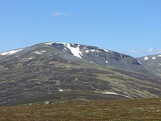
Tom a' Chòinich is a mountain in the Northwest Highlands of Scotland. It is a Munro with a height of 1,112 metres (3,648 ft). Glen Affric is to the south and Loch Mullardoch to the north. Less than 1 kilometre to the west is the 1,032-metre (3,386 ft) Munro Top called Tom a' Chòinich Beag. Its prominence is 149 metres (489 ft) with its parent peak, Càrn Eige, about 4 kilometres (2.5 mi) to the west. This mountain should not be confused with the 955-metre (3,133 ft) Munro Top also called Tom a' Chòinnich near Ben Wyvis.
