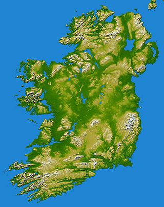
In these lists of mountains in Ireland, those within Northern Ireland, or on the Republic of Ireland – United Kingdom border, are marked with an asterisk, while the rest are within the Republic of Ireland. Where mountains are ranked by height, the definition of the topographical prominence used to classify the mountain, is noted. In British definitions, a height of 600 metres (1,969 ft) is required for a mountain, whereas in Ireland, a lower threshold of 500 metres (1,640 ft) is sometimes advocated.

The mountains and hills of the British Isles are categorised into various lists based on different combinations of elevation, prominence, and other criteria such as isolation. These lists are used for peak bagging, whereby hillwalkers attempt to reach all the summits on a given list, the oldest being the 282 Munros in Scotland, created in 1891.

Knockmealdown is the highest peak of the Knockmealdown Range of mountains, located on the border between counties Tipperary and Waterford.
Knockboy is a 706-metre-high mountain on the border between counties Cork and Kerry in Ireland.
Barrclashcame is a mountain with a height of 772 metres (2,533 ft) in the Sheeffry Hills of County Mayo, Ireland.

Baurtregaum at 851 metres (2,792 ft), is the 13th–highest peak in Ireland on the Arderin scale, and the 18th–highest peak on the Vandeleur-Lynam scale. Baurtregaum is situated at the centre of the massif of the Slieve Mish Mountains on the Dingle Peninsula in County Kerry, Ireland. It is the tallest mountain of the Slieve Mish range, with a number of major subsidiary summits.

Maumtrasna, historically Formnamore, is the highest of the Partry Mountains in south County Mayo, Ireland, rising to 682 metres (2,238 ft) above sea level. The summit is broad and flat with several ridges running off it, including Skeltia, Benwee, Buckaun and Binnaw. The peak of Knocklaur stands on the ridge between Maumtrasna and Devilsmother mountains.

The Comeragh Mountains are a glaciated mountain range situated in southeast Ireland in County Waterford. They are located between the town of Dungarvan and stretch inland to the town of Clonmel on the County Tipperary border and the villages of Kilrossanty and Kilmacthomas in County Waterford.

Cupidstown Hill, at 379 metres (1,243 ft), is the highest point in County Kildare, Ireland, and lies on the fringes of the Wicklow Mountains, 11.6 kilometres (7.2 mi) east of Naas.

Arderin is a mountain on the border between counties Laois and Offaly in Ireland. With a height of 527 metres (1,729 ft) it is the highest point in the Slieve Bloom Mountains, and is the highest point in both counties.

Lyracappul is a mountain in County Limerick in Ireland. At a height of 825 metres (2,707 ft) it is the second highest of the Galtee Mountains and the 29th highest peak in Ireland. Lyracappul is the second highest point in County Limerick.

Trostan is a mountain in County Antrim, Northern Ireland and at 551 metres is the highest point in the county.

Caher or Caher East Top at 1,000 metres (3,300 ft), is the third-highest peak in Ireland, on the Irish Arderin and Vandeleur-Lynam classifications. It is part of the MacGillycuddy's Reeks in County Kerry.

Maolán Buí, also known by the name Bearna Rua, at 973 metres (3,192 ft) high, is the fifth-highest peak in Ireland on the Arderin list, or the sixth-highest peak in Ireland according to the Vandeleur-Lynam list. Maolán Buí is also known for its narrow north-west spur, called The Bone. It is part of the MacGillycuddy's Reeks in County Kerry.

The Bones, at 957 metres (3,140 ft) high, is the seventh-highest peak in Ireland on the Arderin list, or the eighth-highest according to the Vandeleur-Lynam list. It is part of the MacGillycuddy's Reeks in County Kerry, and is a small sharp peak on the dramatic Beenkeragh Ridge, and is sometimes mistaken with The Bone, the north-east spur of Maolán Buí, which descends into the Hag's Glen.
Knockanaffrin is a mountain in County Waterford, Ireland. It is part of the Comeragh Mountains.
Knocknafallia is a 668 m (2,192 ft) high mountain in County Waterford, Ireland.


