Broaghnabinnia

Last updated

Broaghnabinnia
Bruach na Binne
View over the Bridia Valley - geograph.org.uk - 451316.jpg
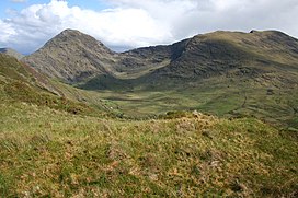
Bridia Valley, with Broaghnabinnia on the left
Highest point
Elevation 745 m (2,444 ft) [1]
Prominence 290 m (950 ft) [1]
Listing Marilyn, Hewitt
Coordinates 51°58′19.2″N9°44′38.4″W / 51.972000°N 9.744000°W / 51.972000; -9.744000 Coordinates: 51°58′19.2″N9°44′38.4″W / 51.972000°N 9.744000°W / 51.972000; -9.744000
Naming
English translationVerge of the peak
Language of name Irish
Geography
Ireland relief location map.png
Red triangle with thick white border.svg
Broaghnabinnia
Parent range Dunkerron Mountains (Mountains of the Iveragh Peninsula)
OSI/OSNI grid V801814
Climbing
Easiest route scrambling

Broaghnabinnia (Irish : Bruach na Binne, meaning "verge of the peak" [2] ) is a summit of the Dunkerron Mountains, part of the Mountains of the Iveragh Peninsula [3] in County Kerry, Ireland.

Contents

Geography

The mountain lies northeast of Stumpa Dúloigh, the highest mountain of the Dunkerron range. With an elevation of 745 metres it is the 80th highest summit in Ireland.[ citation needed ]

Viewed from Stumpa Duloigh Broaghnabinnia.jpg
Viewed from Stumpa Dúloigh

Access to the summit

Broaghnabinnia summit can be accessed scrambling, and is steep on all sides. [1]

Related Research Articles

Iveragh Peninsula Peninsula in County Kerry, Ireland

The Iveragh Peninsula is located in County Kerry in Ireland. It is the largest peninsula in southwestern Ireland. A mountain range, the MacGillycuddy's Reeks, lies in the centre of the peninsula. Carrauntoohil, its highest mountain, is also the highest peak in Ireland.

Carrauntoohil Highest mountain in Ireland

Carrauntoohil or Carrauntoohill is the highest mountain on the island of Ireland at 1,038.6 metres. It is on the Iveragh Peninsula in the Reeks District in County Kerry, close to the centre of Ireland's highest mountain range, MacGillycuddy's Reeks. Carrauntoohil is composed mainly of sandstone, whose glaciation produced distinctive features on the mountain such as the Eagle's Nest corrie and some deep gullies and sharp arêtes in its east and northeastern faces that are popular with rock and winter climbers.

Lists of mountains in Ireland Highest mountains in Ireland

In these lists of mountains in Ireland, those within Northern Ireland, or on the Republic of Ireland – United Kingdom border, are marked with an asterisk, while the rest are within the Republic of Ireland. Where mountains are ranked by height, the definition of the topographical prominence used to classify the mountain, is noted. In British definitions, a height of 600 metres (1,969 ft) is required for a mountain, whereas in Ireland, a lower threshold of 500 metres (1,640 ft) is sometimes advocated.

Mount Brandon Mountain in Kerry, Ireland

Mount Brandon or Brandon, at 952 metres (3,123 ft), is one of the ten highest peaks in Ireland, being the 8th–highest peak in Ireland on the Arderin list, and the 9th–highest on the Vandeleur-Lynam list. Brandon is the highest Irish mountain outside the MacGillycuddy's Reeks range and has the greatest prominence of any Irish peak except Carrauntoohil, Ireland's highest mountain.

Hungry Hill

Hungry Hill is a mountain on the Beara Peninsula, County Cork, in the Republic of Ireland.

Mountains of the Iveragh Peninsula

The Mountains of the Iveragh Peninsula are not found in a single mountain range, but instead consist of a number of unnamed mountain ranges found on the Iveragh Peninsula of County Kerry, in Ireland. The mountains dealt with here include all those found west of Killarney National Park and the MacGillycuddy's Reeks.

Binn idir an dá Log Mountain in Galway, Ireland

Binn idir an dá Log at 702 metres (2,303 ft), is the 87th–highest peak in Ireland on the Arderin scale, and the 108th–highest peak on the Vandeleur-Lynam scale. Binn idir an dá Log is situated at the centre of the long north-west to south-east cental spine of the Maumturks mountain range in the Connemara National Park in Galway, Ireland. Binn idir an dá Log is the tallest mountain in the range.

Geokaun

Geokaun Mountain is the highest mountain on Valentia Island, County Kerry.

Knocknadobar Mountain in Kerry, Ireland

Knocknadobar at 690 metres (2,260 ft), is the 102nd–highest peak in Ireland on the Arderin scale, and the 123rd–highest peak in Ireland according to the Vandeleur-Lynam scale. Knocknadobar is one of the main mountains of the Iveragh Peninsula in County Kerry, Ireland, and has been one of the most important sites of pilgrimage in Ireland since medieval times.

Binn Mhór Mountain in Galway, Ireland

Binn Mhór at 661 metres (2,169 ft), is the 140th–highest peak in Ireland on the Arderin scale, and the 171st–highest peak on the Vandeleur-Lynam scale. Binn Mhór is situated on the southern side of the pass of Máméan, on a small massif that includes Mullach Glas, and Corcogemore ; this massif is at the far southeastern sector of the long north-west to south-east cental spine of the Maumturks mountain range in the Connemara National Park in Galway, Ireland. Binn Mhór is the 3rd-highest mountain in the Maumturks range.

Caher Mountain (Cork)

Caher Mountain is a hill, 338 metres high, with views of the Sheep's Head peninsula, roughly west of and above the village of Kilcrohane in County Cork, Ireland.

Cruach Mhór Mountain in Kerry, Ireland

Cruach Mhór, at 932 metres (3,058 ft) high, is the tenth-highest peak in Ireland on the Arderin list, and the eleventh-highest peak in Ireland according to the Vandeleur-Lynam list. A distinctive square grotto marks the summit. It is part of the MacGillycuddy's Reeks in County Kerry.

Carhoo Hill

Carhoo Hill or Ballymacadoyle Hill is a large hill south-west of Dingle in County Kerry, Ireland.

Scariff Island

Scariff Island is an island of the Atlantic Ocean belonging to County Kerry, Ireland.

Deenish Island

Deenish Island is an island of the Atlantic Ocean belonging to County Kerry, Ireland.

Stumpa Dúloigh Mountain in Kerry, Ireland

Stumpa Dúloigh is the highest summit of the Dunkerron Mountains, part of the Mountains of the Iveragh Peninsula in County Kerry, Ireland.

Mullaghanattin

Mullaghanattin is a summit of the Dunkerron Mountains, part of the Mountains of the Iveragh Peninsula in County Kerry, Ireland.

Mullach Glas Mountain in Galway, Ireland

Mullach Glas at 622 metres (2,041 ft), is the 197th–highest peak in Ireland on the Arderin scale, and the 238th–highest peak on the Vandeleur-Lynam scale. Mullach Glas is located on a small massif that includes Binn Mhór, and Corcogemore ; this massif is at the far southeastern sector of the long north-west to south-east cental spine of the Maumturks mountain range in the Connemara National Park in Galway, Ireland. Mullach Glas is the 5th-highest mountain in the Maumturks range.

Leenaun Hill Mountain in Galway, Ireland

Leenaun Hill at 618 metres (2,028 ft), is the 201st–highest peak in Ireland on the Arderin scale, and the 243rd–highest peak on the Vandeleur-Lynam scale. Leenaun Hill lies on a massif that overlooks Leenaun village and Killary Harbour, and which is at the far northeastern sector of the Maumturks mountain range in the Connemara National Park in Galway, Ireland; this massif is connected to the main range via the "Col of Despondency". Leenaun Hill is the 6th-highest mountain in the Maumturks, and its grassy massif, constructed from sandstone and siltstone, contrasts with the rocky ridges and summits constructed from quartzites, grits, and graphitic, of the middle and southern sectors of the range.

References

  1. 1 2 3 "Dunkerron Mountains Area / Broaghnabinnia". MountainViews.ie . Ordnance Survey Ireland . Retrieved 9 June 2015.
  2. Paul Tempan. "Irish Hill and Mountain Names" (PDF). Mountaineering.ie . Mountaineering Ireland . Retrieved 9 June 2015.
  3. "Hills and Mountains of Britain and Ireland - Ireland : Iveragh Peninsula". www.walkingclub.org.uk. Saturday Walkers Club. Archived from the original on 11 October 2013. Retrieved 9 June 2015.